| Home | City Bus | Maps | Villages | Cities | Rail | Tourist Places | School | College | Pin Codes | Corona Cases Count |
| Distance Calculator Bus Services IFSC Codes Trace Mobile Number Weather Search Place Trace IP Available Cash ATM/Banks Locate Polling Booth Report an Error contact People |
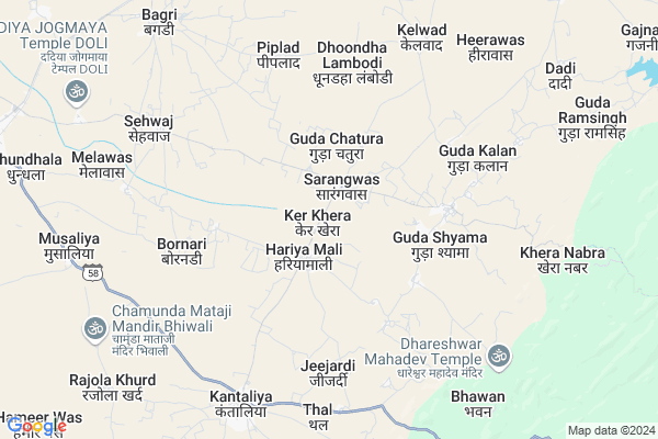
Ker Khera Map
EDIT Map
Add Your House
 ..
..
Current Corona Virus Infected Patients Count in Pali District
| City Name | District Name | Total Covid cases |
|---|---|---|
| Pali District | Pali | 4 |
Locality Name :
Ker Khera
( केर खेरा )
Tehsil Name : Sojat
District : Pali
State : Rajasthan
Division : Jodhpur
Language : Hindi and Rajasthani
Current Time 11:53 AM
Date: Wednesday , Apr 30,2025 (IST)
Time zone: IST (UTC+5:30)
Elevation / Altitude: 295 meters. Above Seal level
Telephone Code / Std Code: 02960
Assembly constituency : Sojat assembly constituency
Assembly MLA : Shobha Chauhan
Lok Sabha constituency : Pali parliamentary constituency
Parliament MP : P. P. CHAUDHARY
Serpanch Name :
Main Village Name : Ker Khera
Commodities Prices : Sojat Road Market / Mandi
Ker Khera Live Weather
Temperature: 37.8 °C
clear sky
Humidity: 16%
Wind : 3.39 mt/sec towards W
StationName : "Rajasthan"
observed on Now
Temperature: 37.8 °C
clear sky
Humidity: 16%
Wind : 3.39 mt/sec towards W
StationName : "Rajasthan"
observed on Now
Ker Khera Weather Forecast for Next 5 days
01-05-2025
30.1°C to 41.3°C
clear sky
30.1°C to 41.3°C
clear sky
02-05-2025
28.2°C to 41.9°C
clear sky, scattered clouds, overcast clouds
28.2°C to 41.9°C
clear sky, scattered clouds, overcast clouds
03-05-2025
27.5°C to 41.3°C
broken clouds, overcast clouds, scattered clouds
27.5°C to 41.3°C
broken clouds, overcast clouds, scattered clouds
04-05-2025
26.3°C to 40.6°C
overcast clouds, broken clouds, scattered clouds, clear sky
26.3°C to 40.6°C
overcast clouds, broken clouds, scattered clouds, clear sky
05-05-2025
24.8°C to 38.3°C
broken clouds, clear sky, few clouds, scattered clouds, moderate rain
24.8°C to 38.3°C
broken clouds, clear sky, few clouds, scattered clouds, moderate rain
National Highways Reachable To Ker Khera
Nationa High Way :NH58
Nationa High Way :NH62
Nationa High Way :NH58
Nationa High Way :NH62
Rivers Near Ker Khera
Nekhadi
Khari
Nekhadi
Khari
About Ker Khera
Correct below Info and add more info about Ker KheraKer Khera is a small Village/hamlet in Sojat Tehsil in Pali District of Rajasthan State, India. It comes under Ker Khera Panchayath. It belongs to Jodhpur Division . It is located 62 KM towards East from District head quarters Pali. 26 KM from Sojat Road. 268 KM from State capital Jaipur
Guda Kallan ( 5 KM ) , Kantaliya ( 7 KM ) , Kelwad ( 7 KM ) , Guda Ram Singh ( 9 KM ) , Musaliya ( 9 KM ) are the nearby Villages to Ker Khera. Ker Khera is surrounded by Sojat Tehsil towards west , Bhim Tehsil towards East , Raipur Tehsil towards North , Deogarh Tehsil towards South .
Sojat , Bilara , Jaitaran , Beawar are the near by Cities to Ker Khera.
Ker Khera 2011 Census Details
Ker Khera Local Language is Hindi. Ker Khera Village Total population is 328 and number of houses are 72. Female Population is 54.9%. Village literacy rate is 62.8% and the Female Literacy rate is 29.6%.
Population
| Census Parameter | Census Data |
| Total Population | 328 |
| Total No of Houses | 72 |
| Female Population % | 54.9 % ( 180) |
| Total Literacy rate % | 62.8 % ( 206) |
| Female Literacy rate | 29.6 % ( 97) |
| Scheduled Tribes Population % | 2.4 % ( 8) |
| Scheduled Caste Population % | 9.5 % ( 31) |
| Working Population % | 25.6 % |
| Child(0 -6) Population by 2011 | 47 |
| Girl Child(0 -6) Population % by 2011 | 48.9 % ( 23) |
Ker Khera Census More Deatils.
Politics in Ker Khera
Bharatiya Janata Party , BJP , INC are the major political parties in this area.Polling Stations /Booths near Ker Khera
1)Government Primary School (l.s.) Chandawal2)Goverment Upper Primary School Saksherta Bhawan Khusalpura
3)Government Upper Primary School Sardarpura
4)Government Primary School Sandmagra
5)Government Upper Primary School Gajnai
HOW TO REACH Ker Khera
By Rail
Bagri Sajjanpur Rail Way Station , Bagri Nagar Rail Way Station are the very nearby railway stations to Ker Khera.Pincodes near Ker Khera
306103 ( Sojat Road ) , 306114 ( Bagri Nagar ) , 305924 ( Todgarh )Colleges near Ker Khera
Bhartiya Vidya Mandir Bed Collage Callage Chimanpura Pali
Address :
Bangur College, Pali
Address :
Govt College Rohat Pali
Address : Jalor Road Rohat
Rajkiya Uach Parthmik School.dantiwara
Address :
Aishwarya College
Address :
Schools near Ker Khera
Goverment Secondry School Mev Pali
Address : main bus stand mev post mev th. sojat
उडान एकेडमी गुड़ा
Address : धरेश्वर रोड गुड़ा कला
Saraswati Public School
Address :
Govt.sen.sec.school Atabara Pali
Address : nayarura mohala
Govt Health Centers near Ker Khera
1) HARIYAMALI , GOVT.PRIMARY HEALTH CENTER HARIYAMALI , MAIN ROAD , MAIN ROAD2) Bornaadi , SC Bornaadi , Bornaadi , Bornaadi
3) Jinjardi , , ,
Sub Villages in Ker Khera
Petrol Bunks in Ker Khera,Sojat
HP PETROL PUMP - HAMARA PUMP SARANGWAS
Tehsil Sojat; District Pali; Sarangwas; Rajasthan 306103; India
1.6 KM distance Detail
more ..
Electronic Shops in Ker Khera,Sojat
Bhavani Repairing Cars Tractors and JCB Contractor
Kantaliya; Rajasthan 306103; India
6.9 KM distance Detail
Police Stations near Ker Khera,Sojat
Police Station Sojat Road
Pali; Pali Road; Sojat Road; Sojat Road; Rajasthan 306103; India
13.2 KM distance Detail
About Ker Khera &
History
How to reach Ker Khera
Tourist Places Near By Ker Khera
Schools in Ker Khera
Colleges in Ker Khera
Temperature & weather of Ker Khera
places in Ker Khera
Ker Khera photos
More Information
How to reach Ker Khera
Tourist Places Near By Ker Khera
Schools in Ker Khera
Colleges in Ker Khera
Temperature & weather of Ker Khera
places in Ker Khera
Ker Khera photos
More Information
Village Talk
Post News or Events about this Village
Near Cities
Sojat 24 KM near
Bilara 43 KM near
Jaitaran 46 KM near
Beawar 60 KM near
Sojat 24 KM near
Bilara 43 KM near
Jaitaran 46 KM near
Beawar 60 KM near
Near By Taluks
Kharchi(Mar.Jun) 22 KM near
Sojat 25 KM near
Bhim 27 KM near
Raipur 39 KM near
Kharchi(Mar.Jun) 22 KM near
Sojat 25 KM near
Bhim 27 KM near
Raipur 39 KM near
Near By Air Ports
Jodhpur Airport 104 KM near
Dabok Airport 152 KM near
Sanganeer Airport 248 KM near
Jaisalmer Airport 356 KM near
Jodhpur Airport 104 KM near
Dabok Airport 152 KM near
Sanganeer Airport 248 KM near
Jaisalmer Airport 356 KM near
Near By Tourist Places
Ranakpur 99 KM near
Bhilwara 106 KM near
Jodhpur 109 KM near
Pushkar 112 KM near
Nathdwara 112 KM near
Ranakpur 99 KM near
Bhilwara 106 KM near
Jodhpur 109 KM near
Pushkar 112 KM near
Nathdwara 112 KM near
Near By Districts
Pali 60 KM near
Rajsamand 96 KM near
Bhilwara 106 KM near
Jodhpur 107 KM near
Pali 60 KM near
Rajsamand 96 KM near
Bhilwara 106 KM near
Jodhpur 107 KM near
Near By RailWay Station
Sojat Road Rail Way Station 12 KM near
Marwar Junction Rail Way Station 31 KM near
Sojat Road Rail Way Station 12 KM near
Marwar Junction Rail Way Station 31 KM near