| Home | City Bus | Maps | Villages | Cities | Rail | Tourist Places | School | College | Pin Codes | Corona Cases Count |
| Distance Calculator Bus Services IFSC Codes Trace Mobile Number Weather Search Place Trace IP Available Cash ATM/Banks Locate Polling Booth Report an Error contact People |
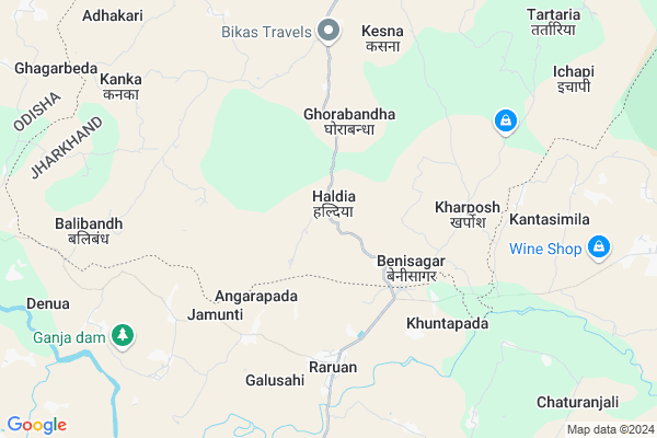
Haldia
Haldia Map
EDIT Map
Add Your House
 ..
..
Current Corona Virus Infected Patients Count in West Singhbhum District
| City Name | District Name | Total Covid cases |
|---|
Locality Name :
Haldia
( हल्दीए )
Block Name : Manjhgaon
District : West Singhbhum
State : Jharkhand
Language : Hindi and Santali
Current Time 08:57 AM
Date: Thursday , Apr 24,2025 (IST)
Time zone: IST (UTC+5:30)
Elevation / Altitude: 438 meters. Above Seal level
Telephone Code / Std Code: 06588
Assembly constituency : Majhgaon assembly constituency
Assembly MLA : NIRAL PURTY
Lok Sabha constituency : Singhbhum parliamentary constituency
Parliament MP : GEETA KORA
Serpanch Name :
Pin Code : 833214
Post Office Name : Hatgamaria
Main Village Name : Haldia
Commodities Prices : Karanjia Market / Mandi
Haldia Live Weather
Temperature: 28.1 °C
clear sky
Humidity: 46%
Wind : 2.2 mt/sec towards S
StationName : "ChÄ\u0081mpua"
observed on 2 Hours Back
Temperature: 28.1 °C
clear sky
Humidity: 46%
Wind : 2.2 mt/sec towards S
StationName : "ChÄ\u0081mpua"
observed on 2 Hours Back
Haldia Weather Forecast for Next 5 days
25-04-2025
25.8°C to 42.4°C
clear sky
25.8°C to 42.4°C
clear sky
26-04-2025
24.3°C to 42.2°C
clear sky
24.3°C to 42.2°C
clear sky
27-04-2025
24.0°C to 39.0°C
clear sky, light rain, scattered clouds, few clouds
24.0°C to 39.0°C
clear sky, light rain, scattered clouds, few clouds
28-04-2025
24.0°C to 40.5°C
scattered clouds, broken clouds, light rain, overcast clouds
24.0°C to 40.5°C
scattered clouds, broken clouds, light rain, overcast clouds
29-04-2025
23.1°C to 36.5°C
overcast clouds, few clouds, clear sky, light rain, scattered clouds
23.1°C to 36.5°C
overcast clouds, few clouds, clear sky, light rain, scattered clouds
National Highways Reachable To Haldia
Nationa High Way :NH320G
Nationa High Way :NH320G
Rivers Near Haldia
Koina River
Meghahatu Nallah
Koina River
Meghahatu Nallah
About Haldia
Correct below Info and add more info about HaldiaHaldia is a small Village/hamlet in Manjhgaon Block in West Singhbhum District of Jharkhand State, India. It comes under Haldia Panchayath. It is located 71 KM towards South from District head quarters Chaibasa. 7 KM from Majhgaon. 186 KM from State capital Ranchi
Haldia Pin code is 833214 and postal head office is Hatgamaria .
Angarpada ( 8 KM ) , Tartaria ( 10 KM ) , Sonaposi ( 11 KM ) , Majhgaon ( 11 KM ) are the nearby Villages to Haldia. Haldia is surrounded by Manjhgaon Block towards North , Sukruli Block towards South , Champua Block towards west , Kumardungi Block towards North .
Karanjia , Joda , Rairangpur , Kendujhar are the near by Cities to Haldia.
This Place is in the border of the West Singhbhum District and Mayurbhanj District. Mayurbhanj District Raruan is South towards this place . It is near to the Odisha State Border.
Haldia 2011 Census Details
Haldia Local Language is Hindi. Haldia Village Total population is 1778 and number of houses are 322. Female Population is 50.2%. Village literacy rate is 28.6% and the Female Literacy rate is 9.4%.
Population
| Census Parameter | Census Data |
| Total Population | 1778 |
| Total No of Houses | 322 |
| Female Population % | 50.2 % ( 893) |
| Total Literacy rate % | 28.6 % ( 508) |
| Female Literacy rate | 9.4 % ( 168) |
| Scheduled Tribes Population % | 89.7 % ( 1594) |
| Scheduled Caste Population % | 0.0 % ( 0) |
| Working Population % | 54.2 % |
| Child(0 -6) Population by 2011 | 397 |
| Girl Child(0 -6) Population % by 2011 | 51.4 % ( 204) |
Haldia Census More Deatils.
Politics in Haldia
Indian National Congress , JBSP , BJP , JMM , are the major political parties in this area.Polling Stations /Booths near Haldia
1)Primary School Dadima2)M/s Majhgaon (west Part)
3)High School Kumardungi (w. Part )
4)Primary School Purniya
5)Primary School Bunumlata
HOW TO REACH Haldia
By Rail
There is no railway station near to Haldia in less than 10 km.Colleges near Haldia
Inter College Manjhgaon
Address :
Schools near Haldia
Madh Vidhyalay Nayagaon
Address : at/p.o Nayagaon Ashram dist.west singhbhum ,jharkhand
Govt Health Centers near Haldia
1) HSC Heperburu , heperburu , heperburu , heperburu2) HSC Ghorabandha , ghorabandha , ghorabandha , ghorabandha
3) HSC Benisagar , Anganwari center , Benisagar majhgaon ,
Sub Villages in Haldia
Petrol Bunks in Haldia,Manjhgaon
Indian Oil Petrol Pump
B.; Ukhunda Champua Rd; Karanjia; Odisha 758044; India
22.1 KM distance Detail
more ..
About Haldia &
History
How to reach Haldia
Tourist Places Near By Haldia
Schools in Haldia
Colleges in Haldia
Temperature & weather of Haldia
places in Haldia
Haldia photos
More Information
How to reach Haldia
Tourist Places Near By Haldia
Schools in Haldia
Colleges in Haldia
Temperature & weather of Haldia
places in Haldia
Haldia photos
More Information
Village Talk
Post News or Events about this Village
Near Cities
Karanjia 31 KM near
Joda 49 KM near
Rairangpur 49 KM near
Kendujhar 54 KM near
Karanjia 31 KM near
Joda 49 KM near
Rairangpur 49 KM near
Kendujhar 54 KM near
Near By Taluks
Raruan 1 KM near
Manjhgaon 7 KM near
Sukruli 13 KM near
Champua 21 KM near
Raruan 1 KM near
Manjhgaon 7 KM near
Sukruli 13 KM near
Champua 21 KM near
Near By Air Ports
Ranchi Airport 175 KM near
Bhubaneswar Airport 217 KM near
Netaji Subhas Chandra Bose Airport 307 KM near
Gaya Airport 357 KM near
Ranchi Airport 175 KM near
Bhubaneswar Airport 217 KM near
Netaji Subhas Chandra Bose Airport 307 KM near
Gaya Airport 357 KM near
Near By Tourist Places
Barehipani & Joranda Barehipani & Joranda Falls 62 KM near
Seraikela 87 KM near
Baripada 101 KM near
Jamshedpur 107 KM near
Rourkela 116 KM near
Barehipani & Joranda Barehipani & Joranda Falls 62 KM near
Seraikela 87 KM near
Baripada 101 KM near
Jamshedpur 107 KM near
Rourkela 116 KM near
Near By Districts
Kendujhar 52 KM near
West Singhbhum 68 KM near
Saraikela Kharsawan 87 KM near
Mayurbhanj 101 KM near
Kendujhar 52 KM near
West Singhbhum 68 KM near
Saraikela Kharsawan 87 KM near
Mayurbhanj 101 KM near
Near By RailWay Station
Dangoaposi Rail Way Station 37 KM near
Goilkera Rail Way Station 83 KM near
Dangoaposi Rail Way Station 37 KM near
Goilkera Rail Way Station 83 KM near