| Home | City Bus | Maps | Villages | Cities | Rail | Tourist Places | School | College | Pin Codes | Corona Cases Count |
| Distance Calculator Bus Services IFSC Codes Trace Mobile Number Weather Search Place Trace IP Available Cash ATM/Banks Locate Polling Booth Report an Error contact People |
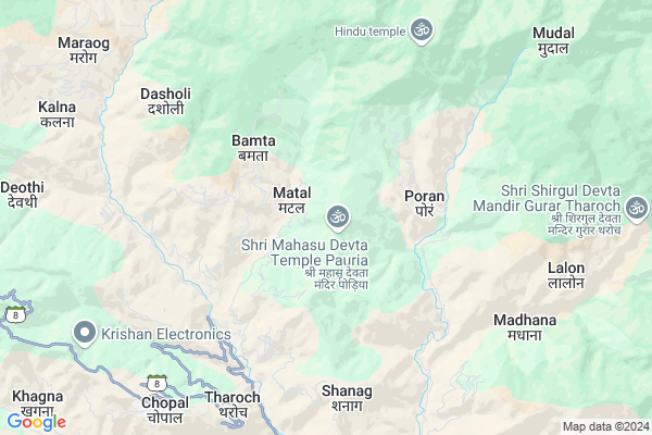
Bagah
Bagah Map
EDIT Map
Add Your House
 ..
..
Current Corona Virus Infected Patients Count in Shimla District
| City Name | District Name | Total Covid cases |
|---|
Locality Name :
Bagah
( बगाह )
Tehsil Name : Chaupal
District : Shimla
State : Himachal Pradesh
Language : Pahari and Hindi, Punjabi
Current Time 12:50 PM
Date: Sunday , Apr 27,2025 (IST)
Time zone: IST (UTC+5:30)
Elevation / Altitude: 1520 meters. Above Seal level
Telephone Code / Std Code: 01783
Assembly constituency : Chopal assembly constituency
Assembly MLA : Sh. Balbir Singh Verma
Lok Sabha constituency : Shimla parliamentary constituency
Parliament MP : SURESH KUMAR KASHYAP
Serpanch Name :
Pin Code : 171210
Post Office Name : Nerwa
Main Village Name : Bagah
Commodities Prices : Rohroo Market / Mandi
National Highways Reachable To Bagah
Nationa High Way :NH707A
Nationa High Way :NH707A
Rivers Near Bagah
Nait ka Khala
Tons
Nait ka Khala
Tons
About Bagah
Correct below Info and add more info about BagahBagah is a small Village/hamlet in Chaupal Tehsil in Shimla District of Himachal Pradesh State, India. It comes under Bagah Panchayath. It is located 53 KM towards East from District head quarters Shimla. 11 KM from Chaupal. 53 KM from State capital Shimla
Bagah Pin code is 171210 and postal head office is Nerwa .
Throach ( 6 KM ) , Bharanu ( 7 KM ) , Madhana ( 8 KM ) , Chaupal ( 8 KM ) , Nerwa ( 11 KM ) are the nearby Villages to Bagah. Bagah is surrounded by Jubbal Kotkhai Tehsil towards North , Rohru Tehsil towards North , Theog Tehsil towards west , Rajgarh Tehsil towards west .
Shimla , Solan , Nahan , Kalka are the near by Cities to Bagah.
Bagah 2011 Census Details
Bagah Local Language is Pahari. Bagah Village Total population is 91 and number of houses are 18. Female Population is 48.4%. Village literacy rate is 63.7% and the Female Literacy rate is 25.3%.
Population
| Census Parameter | Census Data |
| Total Population | 91 |
| Total No of Houses | 18 |
| Female Population % | 48.4 % ( 44) |
| Total Literacy rate % | 63.7 % ( 58) |
| Female Literacy rate | 25.3 % ( 23) |
| Scheduled Tribes Population % | 0.0 % ( 0) |
| Scheduled Caste Population % | 0.0 % ( 0) |
| Working Population % | 70.3 % |
| Child(0 -6) Population by 2011 | 11 |
| Girl Child(0 -6) Population % by 2011 | 45.5 % ( 5) |
Bagah Census More Deatils.
Politics in Bagah
HVC , BJP , INC are the major political parties in this area.Polling Stations /Booths near Bagah
1)Gps Khokhah2)Gps Ghogh
3)Gsss Bagain
4)Gps Padotha (chakhna)
5)Gsss Pabahan
HOW TO REACH Bagah
By Rail
There is no railway station near to Bagah in less than 10 km.Colleges near Bagah
Government Degree College, Nerwa.
Address :
Schools near Bagah
Gsss Pulbahal
Address : pulbahal , chopal , shimla , Himachal Pradesh . PIN- 171226 , Post - Balag
Gsss Halau
Address : halau , nerwa , shimla , Himachal Pradesh . PIN- 171210 , Post - Nerwa
Gsss Maneoti
Address : maneoti , nerwa , shimla , Himachal Pradesh . PIN- 171210 , Post - Nerwa
Gsss Paban
Address : paban , nerwa , shimla , Himachal Pradesh . PIN- 171210 , Post - Nerwa
Govt Health Centers near Bagah
1) Damyana SC , Damyana , Damyana ,2) Khalini SC , Khalini , Khalini , New Temple
3) Deen Dayal Upadhyaya Zonal Hospital , Ram Bazaar, Shimla , Shimla ,
Sub Villages in Bagah
Hospitals in Bagah,Chaupal
राजकीय आयुर्वेदिक औषधालय
천잘; Road; Kharapathar; Himachal Pradesh 171205; India
16.0 KM distance Detail
more ..
Petrol Bunks in Bagah,Chaupal
Kulisht Filling Station Indian Oil Petrol Pump
Majhotli; Shimla; SH-8; Sainj Chopal Nerwa Road; Nerwa; Nerwa; Himachal Pradesh 171211; India
9.2 KM distance Detail
more ..
Colleges in Bagah,Chaupal
Lal Bahadur Shastri Govt. Degree College
Sarswati Nagar; Sawra; Himachal Pradesh 171206; India
20.3 KM distance Detail
more ..
Schools in Bagah,Chaupal
Govt Sen Sec School Dewat
p.o. dewat tehsil chopal distt; Himachal Pradesh; India
5.2 KM distance Detail
Local Parks in Bagah,Chaupal
Kalta Homestay (Advance Booking)
Village-Brall; Teh-Rohru; Shimla; Himachal Pradesh 171206; India
21.2 KM distance Detail
Governement Offices near Bagah,Chaupal
Animals Department Office
Chopal; Shimla; SH-8; Sainj Chopal Nerwa Road; Nerwa; Nerwa; Himachal Pradesh 171211; India
8.4 KM distance Detail
HPSC Branch Manager office
Chopal; Shimla; SH-8; Sainj Chopal Nerwa Road; Nerwa; Nerwa; Himachal Pradesh 171211; India
8.5 KM distance Detail
About Bagah &
History
How to reach Bagah
Tourist Places Near By Bagah
Schools in Bagah
Colleges in Bagah
Temperature & weather of Bagah
places in Bagah
Bagah photos
More Information
How to reach Bagah
Tourist Places Near By Bagah
Schools in Bagah
Colleges in Bagah
Temperature & weather of Bagah
places in Bagah
Bagah photos
More Information
Village Talk
Post News or Events about this Village
Near Cities
Shimla 51 KM near
Solan 60 KM near
Nahan 66 KM near
Kalka 78 KM near
Shimla 51 KM near
Solan 60 KM near
Nahan 66 KM near
Kalka 78 KM near
Near By Taluks
Chaupal 10 KM near
Jubbal Kotkhai 13 KM near
Rohru 25 KM near
Theog 27 KM near
Chaupal 10 KM near
Jubbal Kotkhai 13 KM near
Rohru 25 KM near
Theog 27 KM near
Near By Air Ports
Simla Airport 54 KM near
Dehra Dun Airport 94 KM near
Chandigarh Airport 98 KM near
Bhuntar Airport 135 KM near
Simla Airport 54 KM near
Dehra Dun Airport 94 KM near
Chandigarh Airport 98 KM near
Bhuntar Airport 135 KM near
Near By Tourist Places
Hatkoti 19 KM near
Narkanda 37 KM near
Kufri 41 KM near
Mori 43 KM near
Chakrata 44 KM near
Hatkoti 19 KM near
Narkanda 37 KM near
Kufri 41 KM near
Mori 43 KM near
Chakrata 44 KM near
Near By Districts
Shimla 51 KM near
Solan 57 KM near
Sirmaur 66 KM near
Panchkula 91 KM near
Shimla 51 KM near
Solan 57 KM near
Sirmaur 66 KM near
Panchkula 91 KM near
Near By RailWay Station
Kalka Rail Way Station 78 KM near
Chandi Mandir Rail Way Station 87 KM near
Kalka Rail Way Station 78 KM near
Chandi Mandir Rail Way Station 87 KM near