| Home | City Bus | Maps | Villages | Cities | Rail | Tourist Places | School | College | Pin Codes | Corona Cases Count |
| Distance Calculator Bus Services IFSC Codes Trace Mobile Number Weather Search Place Trace IP Available Cash ATM/Banks Locate Polling Booth Report an Error contact People |
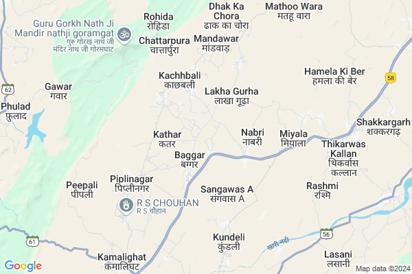
Udpura Map
EDIT Map
Add Your House
 ..
..
Current Corona Virus Infected Patients Count in Rajsamand District
| City Name | District Name | Total Covid cases |
|---|---|---|
| Rajsamand District | Rajsamand | 1 |
Locality Name :
Udpura
( उदपुरा )
Tehsil Name : Bhim
District : Rajsamand
State : Rajasthan
Division : Udaipur
Language : Hindi and Rajasthani
Current Time 11:10 AM
Date: Friday , Mar 14,2025 (IST)
Time zone: IST (UTC+5:30)
Elevation / Altitude: 894 meters. Above Seal level
Telephone Code / Std Code: 02951
Assembly constituency : Bhim assembly constituency
Assembly MLA : Harisingh Rawat S/o Panna Singh
Lok Sabha constituency : Rajsamand parliamentary constituency
Parliament MP : Diya Kumari
Serpanch Name :
Pin Code : 313331
Post Office Name : Deogarh (Rajsamand)
Main Village Name : Udpura
Commodities Prices : Sojat Road Market / Mandi
National Highways Reachable To Udpura
Nationa High Way :NH48
Nationa High Way :NH48
Rivers Near Udpura
Nekhadi
Khari
Nekhadi
Khari
About Udpura
Correct below Info and add more info about UdpuraUdpura is a small Village/hamlet in Bhim Tehsil in Rajsamand District of Rajasthan State, India. It comes under Udpura Panchayath. It belongs to Udaipur Division . It is located 70 KM towards North from District head quarters Rajsamand. 22 KM from Bhim. 280 KM from State capital Jaipur
Udpura Pin code is 313331 and postal head office is Deogarh (Rajsamand).
Lakha Gurha ( 3 KM ) , Kachhbali ( 4 KM ) , Miyala ( 4 KM ) , Vijaypura ( 8 KM ) , Lasani ( 9 KM ) are the nearby Villages to Udpura. Udpura is surrounded by Bhim Tehsil towards East , Kharchi(Mar.Jun) Tehsil towards west , Raipur Tehsil towards South , Amet Tehsil towards South .
Sojat , Rajsamand , Pali , Bilara are the near by Cities to Udpura.
Udpura 2011 Census Details
Udpura Local Language is Hindi. Udpura Village Total population is 145 and number of houses are 26. Female Population is 51.0%. Village literacy rate is 66.2% and the Female Literacy rate is 29.0%.
Population
| Census Parameter | Census Data |
| Total Population | 145 |
| Total No of Houses | 26 |
| Female Population % | 51.0 % ( 74) |
| Total Literacy rate % | 66.2 % ( 96) |
| Female Literacy rate | 29.0 % ( 42) |
| Scheduled Tribes Population % | 0.0 % ( 0) |
| Scheduled Caste Population % | 9.7 % ( 14) |
| Working Population % | 46.2 % |
| Child(0 -6) Population by 2011 | 23 |
| Girl Child(0 -6) Population % by 2011 | 47.8 % ( 11) |
Udpura Census More Deatils.
Politics in Udpura
Bharatiya Janata Party , BJP , INC are the major political parties in this area.Polling Stations /Booths near Udpura
1)Govt.secondary School Lakhaguda (left Part)2)Govt.adarsh Upper Primary School Mediya (right Part)
3)Govt. Primary School Gangaji Ka Khera
4)Nagar Palika Bhawan Deogarh North Part
5)Govt. Adarsh Sr.sec.school Thikarwas Kalan (left Part)
HOW TO REACH Udpura
By Rail
Goram Ghat Rail Way Station , Khamil Ghat Rail Way Station are the very nearby railway stations to Udpura.Colleges near Udpura
Govt. College, Bhim
Address :
Schools in Udpura
G.p.s. Udpura
Address : udpura , bhim , rajsamand , Rajasthan . PIN- 313341 , Post - Barar
Govt Health Centers near Udpura
1) Phulad , SC Phulad , Phulad , Phulad2) Guda Sur Singh , sc Guda Sur Singh , Guda Sur Singh , Guda Sur Singh
3) Chokdiya , SC Chokdiya , Chokdiya , Chokdiya
Sub Villages in Udpura
Hospitals in Udpura,Bhim
Stuti Hospital
Bhim; Rajsamand; NH-8; Rajsamand Road; Devgarh; Deogarh; Rajasthan 305922; India
4.6 KM distance Detail
पशुधन इकाई मण्डावर Animal Hospital Mandawar
Mandawar; Rajasthan 313341; India
5.2 KM distance Detail
more ..
Petrol Bunks in Udpura,Bhim
Reliance Petroleum
KHASRA NO.785/357;NH-8;VILLAGE-KITON KA BADIA;PATWAR KAMLI; KAMLI GHAT CHOURAHA; Deogarh; Rajasthan 313332; India
6.1 KM distance Detail
more ..
Schools in Udpura,Bhim
Government primary school Solikhera
Solikhera; Mediya; Rajasthan 313341; India
2.4 KM distance Detail
Super Markets in Udpura,Bhim
Shree Ram Mobile&Emitra Kachhbali
kachhbali Road; Payari; Rajasthan 313331; India
3.0 KM distance Detail
Governement Offices near Udpura,Bhim
Karyalaya Nagar Palika Mandal
Devgrah; Rajsamand; SH-56; Raajsmand Road; Devgarh; Deogarh; Rajasthan 313331; India
10.6 KM distance Detail
Atal Seva Center
Devgrah; Rajsamand; SH-56; Raajsmand Road; Devgarh; Deogarh; Rajasthan 313331; India
10.7 KM distance Detail
Karyalaya Panchyat Samiti
Devgrah; Rajsamand; SH-56; Raajsmand Road; Devgarh; Deogarh; Rajasthan 313331; India
10.8 KM distance Detail
About Udpura &
History
How to reach Udpura
Tourist Places Near By Udpura
Schools in Udpura
Colleges in Udpura
Temperature & weather of Udpura
places in Udpura
Udpura photos
More Information
How to reach Udpura
Tourist Places Near By Udpura
Schools in Udpura
Colleges in Udpura
Temperature & weather of Udpura
places in Udpura
Udpura photos
More Information
Village Talk
Post News or Events about this Village
Near Cities
Sojat 48 KM near
Rajsamand 65 KM near
Pali 70 KM near
Bilara 72 KM near
Sojat 48 KM near
Rajsamand 65 KM near
Pali 70 KM near
Bilara 72 KM near
Near By Taluks
Deogarh 15 KM near
Bhim 21 KM near
Kharchi(Mar.Jun) 23 KM near
Raipur 39 KM near
Deogarh 15 KM near
Bhim 21 KM near
Kharchi(Mar.Jun) 23 KM near
Raipur 39 KM near
Near By Air Ports
Dabok Airport 123 KM near
Jodhpur Airport 126 KM near
Sanganeer Airport 259 KM near
Ahmedabad Airport 348 KM near
Dabok Airport 123 KM near
Jodhpur Airport 126 KM near
Sanganeer Airport 259 KM near
Ahmedabad Airport 348 KM near
Near By Tourist Places
Ranakpur 76 KM near
Nathdwara 84 KM near
Bhilwara 88 KM near
Kumbhalgarh 89 KM near
Jodhpur 130 KM near
Ranakpur 76 KM near
Nathdwara 84 KM near
Bhilwara 88 KM near
Kumbhalgarh 89 KM near
Jodhpur 130 KM near
Near By Districts
Rajsamand 68 KM near
Pali 68 KM near
Bhilwara 88 KM near
Chittorgarh 121 KM near
Rajsamand 68 KM near
Pali 68 KM near
Bhilwara 88 KM near
Chittorgarh 121 KM near
Near By RailWay Station
Goram Ghat Rail Way Station 7.3 KM near
Khamil Ghat Rail Way Station 8.7 KM near
Sojat Road Rail Way Station 35 KM near
Marwar Junction Rail Way Station 36 KM near
Goram Ghat Rail Way Station 7.3 KM near
Khamil Ghat Rail Way Station 8.7 KM near
Sojat Road Rail Way Station 35 KM near
Marwar Junction Rail Way Station 36 KM near