| Home | City Bus | Maps | Villages | Cities | Rail | Tourist Places | School | College | Pin Codes | Corona Cases Count |
| Distance Calculator Bus Services IFSC Codes Trace Mobile Number Weather Search Place Trace IP Available Cash ATM/Banks Locate Polling Booth Report an Error contact People |
Mandla
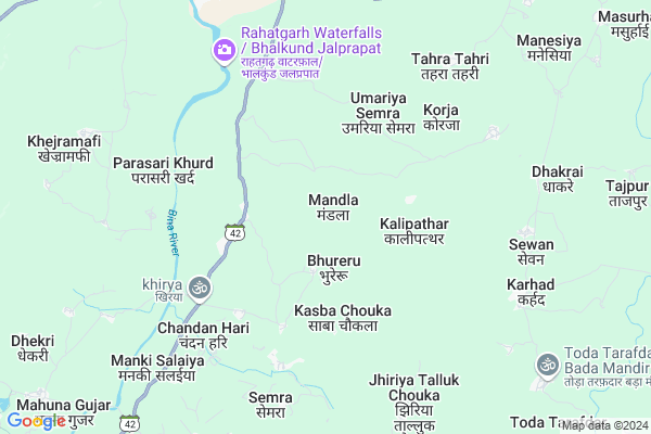
Mandla Map
EDIT Map
Add Your House
 ..
..
Current Corona Virus Infected Patients Count in Raisen District
| City Name | District Name | Total Covid cases |
|---|---|---|
| Raisen District | Raisen | 27 |
Locality Name :
Mandla
( मंडला )
Tehsil Name : Begamganj
District : Raisen
State : Madhya Pradesh
Division : Bhopal
Language : Hindi
Current Time 04:46 AM
Date: Saturday , Apr 26,2025 (IST)
Time zone: IST (UTC+5:30)
Elevation / Altitude: 487 meters. Above Seal level
Telephone Code / Std Code: 07487
Assembly constituency : Silwani assembly constituency
Assembly MLA : Devendra Patel
Lok Sabha constituency : Vidisha parliamentary constituency
Parliament MP : Ramakant Bhargava
Serpanch Name :
Pin Code : 464881
Post Office Name : Begumganj
Main Village Name : Mandla
Commodities Prices : Rahatgarh Market / Mandi
Mandla Live Weather
Temperature: 30.1 °C
few clouds
Humidity: 16%
Wind : 2.39 mt/sec towards W
StationName : "RÄ\u0081hatgarh"
observed on 2 Hours Back
Temperature: 30.1 °C
few clouds
Humidity: 16%
Wind : 2.39 mt/sec towards W
StationName : "RÄ\u0081hatgarh"
observed on 2 Hours Back
Mandla Weather Forecast for Next 5 days
27-04-2025
28.2°C to 36.8°C
light rain, overcast clouds, broken clouds, scattered clouds
28.2°C to 36.8°C
light rain, overcast clouds, broken clouds, scattered clouds
28-04-2025
26.9°C to 39.7°C
scattered clouds, few clouds, broken clouds, clear sky
26.9°C to 39.7°C
scattered clouds, few clouds, broken clouds, clear sky
29-04-2025
27.1°C to 41.7°C
few clouds, clear sky, scattered clouds, overcast clouds
27.1°C to 41.7°C
few clouds, clear sky, scattered clouds, overcast clouds
30-04-2025
30.1°C to 41.7°C
overcast clouds, scattered clouds, few clouds, broken clouds
30.1°C to 41.7°C
overcast clouds, scattered clouds, few clouds, broken clouds
Rivers Near Mandla
Betwa
Halali
Betwa
Halali
About Mandla
Correct below Info and add more info about MandlaMandla is a small Village/hamlet in Begamganj Tehsil in Raisen District of Madhya Pradesh State, India. It comes under Mandla Panchayath. It belongs to Bhopal Division . It is located 93 KM towards East from District head quarters Raisen. 23 KM from Begamganj. 135 KM from State capital Bhopal
Mandla Pin code is 464881 and postal head office is Begumganj .
Sumer ( 14 KM ) , Kokalpur ( 14 KM ) , Hapsili ( 16 KM ) are the nearby Villages to Mandla. Mandla is surrounded by Jaisinagar Tehsil towards East , Begamganj Tehsil towards South , Gyaraspur Tehsil towards west , Sagar Tehsil towards East .
Rahatgarh , Sagar , Khurai , Rehli are the near by Cities to Mandla.
Mandla 2011 Census Details
Mandla Local Language is Hindi. Mandla Village Total population is 407 and number of houses are 91. Female Population is 47.7%. Village literacy rate is 64.1% and the Female Literacy rate is 28.7%.
Population
| Census Parameter | Census Data |
| Total Population | 407 |
| Total No of Houses | 91 |
| Female Population % | 47.7 % ( 194) |
| Total Literacy rate % | 64.1 % ( 261) |
| Female Literacy rate | 28.7 % ( 117) |
| Scheduled Tribes Population % | 13.5 % ( 55) |
| Scheduled Caste Population % | 47.2 % ( 192) |
| Working Population % | 43.0 % |
| Child(0 -6) Population by 2011 | 84 |
| Girl Child(0 -6) Population % by 2011 | 47.6 % ( 40) |
Mandla Census More Deatils.
Politics in Mandla
Bharatiya Janata Party , BJP , SP , INC are the major political parties in this area.Polling Stations /Booths near Mandla
1)Juniya2)Chandabad
3)Jasarathi
4)Bhaisara
5)Madhiya Mahuakheda
HOW TO REACH Mandla
By Rail
There is no railway station near to Mandla in less than 10 km.Colleges near Mandla
Bansal College Of Engineering
Address : Bansal College Of Engineering Bisen Road Goharganj
Schools in Mandla
Mandla Hinotia
Address : mandla , begamganj , raisen , Madhya Pradesh . PIN- 464881 , Post - Begumganj
Govt Health Centers near Mandla
1) SHC Bhureru , , ,2) SHC Tehra-Tehri , SHC Tehra-Tehri , Tehra-Tehri , Tehra-Tehri
3) SHC Manki Salaiya , SHC Manki Salaiya , Manki Salaiya , SHC Manki Salaiya
Sub Villages in Mandla
Petrol Bunks in Mandla,Begamganj
Indian Oil Petrol Pump
Rahatgarh; Sagar; NH-86; Sagar Rahatgarh Road; Sagar; Sagar; Madhya Pradesh 470119; India
8.8 KM distance Detail
more ..
Electronic Shops in Mandla,Begamganj
Delux Armature Battery
Gairatganj Rd; Shikarpur; Madhya Pradesh 470119; India
8.9 KM distance Detail
Local Parks in Mandla,Begamganj
कीतिॅ स्तॅभ विदिशा तिराहा
Gairatganj Rd; Rahatgarh; Madhya Pradesh 470119; India
9.6 KM distance Detail
Police Stations near Mandla,Begamganj
Police Station Begamganj
Begamganj; Raisen; NH-86; Gairatganj Road; Raisen; Raisen; Madhya Pradesh 464881; India
19.7 KM distance Detail
Governement Offices near Mandla,Begamganj
Forest Office
Gazikheda; Sagar; NH-86; Gairatganj Road; Sagar; Sagar; Madhya Pradesh 470119; India
5.9 KM distance Detail
About Mandla &
History
How to reach Mandla
Tourist Places Near By Mandla
Schools in Mandla
Colleges in Mandla
Temperature & weather of Mandla
places in Mandla
Mandla photos
More Information
How to reach Mandla
Tourist Places Near By Mandla
Schools in Mandla
Colleges in Mandla
Temperature & weather of Mandla
places in Mandla
Mandla photos
More Information
Village Talk
Post News or Events about this Village
Near Cities
Rahatgarh 8 KM near
Sagar 38 KM near
Khurai 40 KM near
Rehli 74 KM near
Rahatgarh 8 KM near
Sagar 38 KM near
Khurai 40 KM near
Rehli 74 KM near
Near By Taluks
Rahatgarh 13 KM near
Jaisinagar 21 KM near
Begamganj 22 KM near
Gyaraspur 41 KM near
Rahatgarh 13 KM near
Jaisinagar 21 KM near
Begamganj 22 KM near
Gyaraspur 41 KM near
Near By Air Ports
Bhopal Airport 135 KM near
Jabalpur Airport 215 KM near
Khajuraho Airport 217 KM near
Gwalior Airport 321 KM near
Bhopal Airport 135 KM near
Jabalpur Airport 215 KM near
Khajuraho Airport 217 KM near
Gwalior Airport 321 KM near
Near By Tourist Places
Vidisha 73 KM near
Sanchi 84 KM near
Raisen 88 KM near
Deogarh 102 KM near
Chanderi 129 KM near
Vidisha 73 KM near
Sanchi 84 KM near
Raisen 88 KM near
Deogarh 102 KM near
Chanderi 129 KM near
Near By Districts
Sagar 38 KM near
Vidisha 74 KM near
Raisen 89 KM near
Damoh 115 KM near
Sagar 38 KM near
Vidisha 74 KM near
Raisen 89 KM near
Damoh 115 KM near
Near By RailWay Station
Saugor Rail Way Station 39 KM near
Khurai Rail Way Station 42 KM near
Saugor Rail Way Station 39 KM near
Khurai Rail Way Station 42 KM near