| Home | City Bus | Maps | Villages | Cities | Rail | Tourist Places | School | College | Pin Codes | Corona Cases Count |
| Distance Calculator Bus Services IFSC Codes Trace Mobile Number Weather Search Place Trace IP Available Cash ATM/Banks Locate Polling Booth Report an Error contact People |
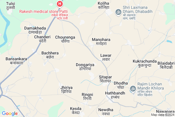
Hathband
Hathband Map
EDIT Map
Add Your House
 ..
..
Current Corona Virus Infected Patients Count in Raipur District
| City Name | District Name | Total Covid cases |
|---|---|---|
| Raipur District | Raipur | 3 |
| Raipur | Raipur | 3 |
Locality Name :
Hathband
( हथबंद )
Tehsil Name : Simga
District : Raipur
State : Chattisgarh
Language : Chhattisgarhi and Hindi
Current Time 07:05 AM
Date: Saturday , Apr 26,2025 (IST)
Time zone: IST (UTC+5:30)
Elevation / Altitude: 283 meters. Above Seal level
Telephone Code / Std Code: 07721
Assembly constituency : Bhatapara assembly constituency
Assembly MLA : Indra Sao
Lok Sabha constituency : Raipur parliamentary constituency
Parliament MP : Sunil Kumar Soni
Serpanch Name :
Pin Code : 493113
Post Office Name : Hathband
Main Village Name : Hathband
Commodities Prices : Neora Market / Mandi
Hathband Live Weather
Temperature: 29.9 °C
few clouds
Humidity: 16%
Wind : 1.58 mt/sec towards SW
StationName : "Simga"
observed on 2 Hours Back
Temperature: 29.9 °C
few clouds
Humidity: 16%
Wind : 1.58 mt/sec towards SW
StationName : "Simga"
observed on 2 Hours Back
Hathband Weather Forecast for Next 5 days
27-04-2025
29.5°C to 43.9°C
few clouds, clear sky, broken clouds, overcast clouds
29.5°C to 43.9°C
few clouds, clear sky, broken clouds, overcast clouds
28-04-2025
27.5°C to 39.0°C
overcast clouds, broken clouds, light rain, scattered clouds, clear sky
27.5°C to 39.0°C
overcast clouds, broken clouds, light rain, scattered clouds, clear sky
29-04-2025
26.9°C to 42.3°C
clear sky, few clouds, broken clouds, scattered clouds
26.9°C to 42.3°C
clear sky, few clouds, broken clouds, scattered clouds
30-04-2025
26.7°C to 43.5°C
scattered clouds, clear sky, broken clouds
26.7°C to 43.5°C
scattered clouds, clear sky, broken clouds
Rivers Near Hathband
Khorsi
Mahanadi :Mahanadi River :महानदी नदी
Khorsi
Mahanadi :Mahanadi River :महानदी नदी
About Hathband
Correct below Info and add more info about HathbandHathband is a small Village/hamlet in Simga Tehsil in Raipur District of Chattisgarh State, India. It comes under Hathband Panchayath. It is located 59 KM towards North from District head quarters Raipur. 58 KM from State capital Raipur
Hathband Pin code is 493113 and postal head office is Hathband .
Hathband is surrounded by Tilda Tehsil towards South , Bhatapara Tehsil towards East , Nawagarh Tehsil towards North , Bemetara Tehsil towards west .
Tilda Newra , Bhatapara , Bemetra , Baloda Bazar are the near by Cities to Hathband.
This Place is in the border of the Raipur District and Durg District. Durg District Bemetara is west towards this place .
Hathband 2011 Census Details
Hathband Local Language is Chhattisgarhi. Hathband Village Total population is 2425 and number of houses are 544. Female Population is 49.8%. Village literacy rate is 66.2% and the Female Literacy rate is 29.9%.
Population
| Census Parameter | Census Data |
| Total Population | 2425 |
| Total No of Houses | 544 |
| Female Population % | 49.8 % ( 1207) |
| Total Literacy rate % | 66.2 % ( 1605) |
| Female Literacy rate | 29.9 % ( 725) |
| Scheduled Tribes Population % | 11.6 % ( 281) |
| Scheduled Caste Population % | 24.6 % ( 596) |
| Working Population % | 38.2 % |
| Child(0 -6) Population by 2011 | 367 |
| Girl Child(0 -6) Population % by 2011 | 45.8 % ( 168) |
Hathband Census More Deatils.
Politics in Hathband
Bharatiya Janata Party , BJP , INC are the major political parties in this area.Polling Stations /Booths near Hathband
1)Dhurrabandha2)Dongriya
3)Bhatapara
4)Jarhagaon
5)Chandli
HOW TO REACH Hathband
By Rail
Hathbandh Rail Way Station is the very nearby railway stations to Hathband.Colleges near Hathband
College Of Agriculture
Address :
Set Fulcha Agrawall Smrity Mahavidyalay Nawapara
Address :
Sahid Veer Narayan Singh Govt. Collage Bilaigarh
Address :
Kruti Institute Of Techology And Engineering
Address : 2km From Vidhan Sabha
Govt Brijlal Verma Collage, Palari, Balodabazar
Address :
Schools near Hathband
Bandna Publick School
Address : simga , simga , raipur , Chattisgarh . PIN- 493101 , Post - Simga
Shakti Convent School
Address : simga , simga , raipur , Chattisgarh . PIN- 493101 , Post - Simga
Govt M.s.
Address : nawagaon , simga , raipur , Chattisgarh . PIN- 493101 , Post - Simga
Govt.n.m.s.dhodha
Address : dhoda , simga , raipur , Chattisgarh . PIN- 493113 , Post - Hathband
Govt Health Centers near Hathband
1) SHC Mohbhatta(RPR) , , Bazar Chaowk School Ke Pass Mohbhatta ,2) SHC Dogaria , , School Chawok Dongariya ,
3) PHC Hatband , , Suhela Road Hatnband ,
Sub Villages in Hathband
Governement Offices near Hathband,Simga
choice Centre (CYBERZONE) आधार केंद्र
Baloda Bazaar; Chhattisgarh 493101; India
13.7 KM distance Detail
About Hathband &
History
How to reach Hathband
Tourist Places Near By Hathband
Schools in Hathband
Colleges in Hathband
Temperature & weather of Hathband
places in Hathband
Hathband photos
More Information
How to reach Hathband
Tourist Places Near By Hathband
Schools in Hathband
Colleges in Hathband
Temperature & weather of Hathband
places in Hathband
Hathband photos
More Information
Village Talk
Post News or Events about this Village
Near Cities
Tilda Newra 15 KM near
Bhatapara 16 KM near
Bemetra 33 KM near
Baloda Bazar 39 KM near
Tilda Newra 15 KM near
Bhatapara 16 KM near
Bemetra 33 KM near
Baloda Bazar 39 KM near
Near By Taluks
Simga 0 KM near
Tilda 23 KM near
Bhatapara 24 KM near
Nawagarh 28 KM near
Simga 0 KM near
Tilda 23 KM near
Bhatapara 24 KM near
Nawagarh 28 KM near
Near By Air Ports
Raipur Airport 61 KM near
Jabalpur Airport 251 KM near
Sonegaon Airport 328 KM near
Khajuraho Airport 448 KM near
Raipur Airport 61 KM near
Jabalpur Airport 251 KM near
Sonegaon Airport 328 KM near
Khajuraho Airport 448 KM near
Near By Tourist Places
Raipur 56 KM near
Bilaspur 62 KM near
Bhilai 76 KM near
Mahasamund 77 KM near
Kawardha 79 KM near
Raipur 56 KM near
Bilaspur 62 KM near
Bhilai 76 KM near
Mahasamund 77 KM near
Kawardha 79 KM near
Near By Districts
Raipur 57 KM near
Bilaspur 63 KM near
Mahasamund 76 KM near
Kabirdham 80 KM near
Raipur 57 KM near
Bilaspur 63 KM near
Mahasamund 76 KM near
Kabirdham 80 KM near
Near By RailWay Station
Hathbandh Rail Way Station 6.0 KM near
Tilda Rail Way Station 15 KM near
Bhatapara Rail Way Station 16 KM near
Hathbandh Rail Way Station 6.0 KM near
Tilda Rail Way Station 15 KM near
Bhatapara Rail Way Station 16 KM near