| Home | City Bus | Maps | Villages | Cities | Rail | Tourist Places | School | College | Pin Codes | Corona Cases Count |
| Distance Calculator Bus Services IFSC Codes Trace Mobile Number Weather Search Place Trace IP Available Cash ATM/Banks Locate Polling Booth Report an Error contact People |
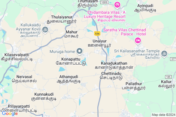
Athanur
Athanur Map
EDIT Map
Add Your House
 ..
..
Current Corona Virus Infected Patients Count in Pudukkottai District
| City Name | District Name | Total Covid cases |
|---|---|---|
| Pudukkottai District | Pudukkottai | 1 |
Locality Name :
Athanur
( அதனுள் )
Block Name : Tirumayam
District : Pudukkottai
State : Tamil Nadu
Language : Tamil
Current Time 07:05 AM
Date: Saturday , Apr 26,2025 (IST)
Time zone: IST (UTC+5:30)
Elevation / Altitude: 98 meters. Above Seal level
Telephone Code / Std Code: 04322
Assembly constituency : Thirumayam assembly constituency
Assembly MLA : S.Regupathy
Lok Sabha constituency : Sivaganga parliamentary constituency
Parliament MP : KARTI P CHIDAMBARAM
Serpanch Name :
Pin Code : 622503
Post Office Name : Konapet
Main Village Name : Athanur
Commodities Prices : Alangudi Market / Mandi
Edit below overview about Athanur
Edit below overview about Athanur
OverView of Athanur
In this village have two very famous temples first one is kailasanathar temple and second one is sengamala valli Amman temple both are thousands year before builtEdit below overview about Athanur
National Highways Reachable To Athanur
Nationa High Way :NH36
Nationa High Way :NH32
Nationa High Way :NH36
Nationa High Way :NH32
Rivers Near Athanur
Nerinjikkudi Ar
Vellar River :வெள்ளாறு
Nerinjikkudi Ar
Vellar River :வெள்ளாறு
About Athanur
Athanur is a small Village/hamlet in Tirumayam Block in Pudukkottai District of Tamil Nadu State, India. It comes under Athanur Panchayath. It is located 27 KM towards South from District head quarters Pudukkottai. 11 KM from Thirumayam. 420 KM from State capital Chennai
Athanur Pin code is 622503 and postal head office is Konapet .
Sivaganga ( 4 KM ) , Oonaiyur ( 5 KM ) , Thulaiyanur ( 6 KM ) , Thulaiyanur ( 6 KM ) , Vanniulandanvayal ( 7 KM ) are the nearby Villages to Athanur. Athanur is surrounded by Sakkottai Block towards South , Arimalam Block towards East , Tiruppathur Block towards west , Kallal Block towards South .
Karaikudi , Pudukkottai , Sivaganga , Peravurani are the near by Cities to Athanur.
This Place is in the border of the Pudukkottai District and Sivaganga District. Sivaganga District Kannankudi is South towards this place .
Demographics of Athanur
Tamil is the Local Language here.Politics in Athanur
DMK , AIADMK , TMC(M) , INC , ADMK are the major political parties in this area.Polling Stations /Booths near Athanur
1)Pues Tiled Building North Side Mirattunilai 6222012)Panchayat Union Middle School New Terraced Building East Side Pillamangalam
3)Pums Ssa Bld. West Side Kadayakudi 622506
4)Sri Saraswathi Elementary School Main Building Konapattu 622503
5)Sri Saraswathi Higher Secondary School East Building South Side Konapattu 622503
HOW TO REACH Athanur
By Rail
Chettinad Rail Way Station , Tirumayam Rail Way Station are the very nearby railway stations to Athanur.Colleges near Athanur
Mount Zion College Of Engineering And Technology
Address : Thirumayam (tk) Pudukkottai (dt) Puddukkottai-62
Chenduran Polytechnic College
Address : Chenduran Polytechnic College, Madurai Main Road,
Mount Zion College Of Nursing
Address : Pilivalam P.o., Tirumayam, Pudukkottai-622507, Tam
Schools in Athanur
Pums.athanur
Address : athanur , thirumayam , pudukkottai , Tamil Nadu . PIN- 622503 , Post - Konapet
Govt Health Centers near Athanur
1) Athanur , Heath Sub Centre , Nemathanpatti Road , Opp to Panjayat Union Middle School2) Aranmanaipatty , , Aranmanaipatti , near IOB
3) Konapattu , Primary Health Centre , Nemathanpatti Road , Nemathanpatti Road
Sub Villages in Athanur
Colleges in Athanur,Tirumayam
A C Muthiah Private Vocational Training Institute
S P K Street; Konapet; Pudukkottai; Tamil Nadu; India
3.1 KM distance Detail
MR AR Vocational Training Center
Omayalpuram; Pudukkottai-Karaikkudi Road; Sivaganga; Tamil Nadu 622505; India
3.4 KM distance Detail
more ..
Electronic Shops in Athanur,Tirumayam
MAP Computers
1406/3;MKA Complex; Pudukkottai-Karaikkudi Road; Tamil Nadu 630103; India
3.0 KM distance Detail
Police Stations near Athanur,Tirumayam
ladies police station அனைத்து மகளிர் காவல் நிலையம்
Thirumayam; Tamil Nadu 622507; India
8.2 KM distance Detail
About Athanur &
History
How to reach Athanur
Tourist Places Near By Athanur
Schools in Athanur
Colleges in Athanur
Temperature & weather of Athanur
places in Athanur
Athanur photos
More Information
How to reach Athanur
Tourist Places Near By Athanur
Schools in Athanur
Colleges in Athanur
Temperature & weather of Athanur
places in Athanur
Athanur photos
More Information
Village Talk
Post News or Events about this Village
Near Cities
Karaikudi 15 KM near
Pudukkottai 26 KM near
Sivaganga 52 KM near
Peravurani 56 KM near
Karaikudi 15 KM near
Pudukkottai 26 KM near
Sivaganga 52 KM near
Peravurani 56 KM near
Near By Taluks
Tirumayam 11 KM near
Sakkottai 15 KM near
Arimalam 15 KM near
Tiruppathur 17 KM near
Tirumayam 11 KM near
Sakkottai 15 KM near
Arimalam 15 KM near
Tiruppathur 17 KM near
Near By Air Ports
Civil Airport 72 KM near
Madurai Airport 91 KM near
Salem Airport 196 KM near
Tuticorin Airport 202 KM near
Civil Airport 72 KM near
Madurai Airport 91 KM near
Salem Airport 196 KM near
Tuticorin Airport 202 KM near
Near By Tourist Places
Chettinad 4 KM near
Karaikudi 15 KM near
Tiruchy 76 KM near
Madurai 83 KM near
Thanjavur 88 KM near
Chettinad 4 KM near
Karaikudi 15 KM near
Tiruchy 76 KM near
Madurai 83 KM near
Thanjavur 88 KM near
Near By Districts
Pudukkottai 26 KM near
Sivaganga 52 KM near
Tiruchirappalli 78 KM near
Madurai 83 KM near
Pudukkottai 26 KM near
Sivaganga 52 KM near
Tiruchirappalli 78 KM near
Madurai 83 KM near
Near By RailWay Station
Chettinad Rail Way Station 4.7 KM near
Tirumayam Rail Way Station 8.1 KM near
Karaikkudi Junction Rail Way Station 14 KM near
Devakottai Road Rail Way Station 17 KM near
Chettinad Rail Way Station 4.7 KM near
Tirumayam Rail Way Station 8.1 KM near
Karaikkudi Junction Rail Way Station 14 KM near
Devakottai Road Rail Way Station 17 KM near