| Home | City Bus | Maps | Villages | Cities | Rail | Tourist Places | School | College | Pin Codes | Corona Cases Count |
| Distance Calculator Bus Services IFSC Codes Trace Mobile Number Weather Search Place Trace IP Available Cash ATM/Banks Locate Polling Booth Report an Error contact People |
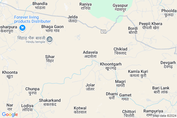
Adavela
Adavela Map
EDIT Map
Add Your House
 ..
..
Current Corona Virus Infected Patients Count in Pratapgarh District
| City Name | District Name | Total Covid cases |
|---|---|---|
| Pratapgarh District | Pratapgarh | 2 |
Locality Name :
Adavela
( ाडवेला )
Tehsil Name : Pratapgarh
District : Pratapgarh
State : Rajasthan
Division : Udaipur
Language : Hindi and Rajasthani
Current Time 04:09 PM
Date: Tuesday , Apr 29,2025 (IST)
Time zone: IST (UTC+5:30)
Elevation / Altitude: 455 meters. Above Seal level
Telephone Code / Std Code: 01479
Assembly constituency : Bari Sadri assembly constituency
Assembly MLA : Gautam Kumar
Lok Sabha constituency : Chittorgarh parliamentary constituency
Parliament MP : Chandra Prakash Joshi
Serpanch Name :
Main Village Name : Adavela
Commodities Prices : Badrisadri Market / Mandi
Adavela Live Weather
Temperature: 41.6 °C
scattered clouds
Humidity: 10%
Wind : 7.24 mt/sec towards SW
StationName : "PratÄ\u0081pgarh"
observed on 5 Mins Back
Temperature: 41.6 °C
scattered clouds
Humidity: 10%
Wind : 7.24 mt/sec towards SW
StationName : "PratÄ\u0081pgarh"
observed on 5 Mins Back
Adavela Weather Forecast for Next 5 days
30-04-2025
30.1°C to 39.9°C
scattered clouds, broken clouds, few clouds
30.1°C to 39.9°C
scattered clouds, broken clouds, few clouds
01-05-2025
27.6°C to 42.0°C
clear sky, scattered clouds, broken clouds
27.6°C to 42.0°C
clear sky, scattered clouds, broken clouds
02-05-2025
27.8°C to 43.3°C
clear sky, few clouds, broken clouds, scattered clouds
27.8°C to 43.3°C
clear sky, few clouds, broken clouds, scattered clouds
03-05-2025
27.7°C to 42.2°C
clear sky
27.7°C to 42.2°C
clear sky
04-05-2025
26.3°C to 39.8°C
clear sky
26.3°C to 39.8°C
clear sky
National Highways Reachable To Adavela
Nationa High Way :NH156
Nationa High Way :NH156
Rivers Near Adavela
Jakam
Mahi
Jakam
Mahi
About Adavela
Correct below Info and add more info about AdavelaAdavela is a small Village/hamlet in Pratapgarh Tehsil in Pratapgarh District of Rajasthan State, India. It comes under Adavela Panchayath. It belongs to Udaipur Division . It is located 27 KM towards west from District head quarters Pratapgarh. 24 KM from Pratapgarh. 402 KM from State capital Jaipur
Pipaliya ( 6 KM ) , Gyaspur ( 7 KM ) , Devgarh ( 10 KM ) , Lodiya ( 11 KM ) , Ram Puriya ( 12 KM ) are the nearby Villages to Adavela. Adavela is surrounded by Pratapgarh Tehsil towards East , Peepal Khoont Tehsil towards South , Ghatol Tehsil towards South , Chhoti Sadri Tehsil towards North .
Pratapgarh , Mandsaur , Banswara , Neemuch are the near by Cities to Adavela.
Adavela 2011 Census Details
Adavela Local Language is Hindi. Adavela Village Total population is 892 and number of houses are 193. Female Population is 49.3%. Village literacy rate is 49.1% and the Female Literacy rate is 17.2%.
Population
| Census Parameter | Census Data |
| Total Population | 892 |
| Total No of Houses | 193 |
| Female Population % | 49.3 % ( 440) |
| Total Literacy rate % | 49.1 % ( 438) |
| Female Literacy rate | 17.2 % ( 153) |
| Scheduled Tribes Population % | 99.8 % ( 890) |
| Scheduled Caste Population % | 0.0 % ( 0) |
| Working Population % | 62.6 % |
| Child(0 -6) Population by 2011 | 209 |
| Girl Child(0 -6) Population % by 2011 | 49.3 % ( 103) |
Adavela Census More Deatils.
Politics in Adavela
Bharatiya Janata Party , BJP , INC are the major political parties in this area.Polling Stations /Booths near Adavela
1)Govt.upp. Primary School Charliya2)Govt. Primary School Kheda Ahiran
3)Govt. Secondary School Gardana
4)Govt.upp. Primary School Sadal Kheda
5)Govt. Senior Secondaryschool Khodip (south Part)
HOW TO REACH Adavela
By Rail
There is no railway station near to Adavela in less than 10 km.Pincodes near Adavela
313611 ( Parsola ) , 312605 ( Pratap garh (Chittorgarh) ) , 313605 ( Dhariawad )Colleges near Adavela
Government P. G. College Of Pratapgarh
Address : Government P. G. College Of Pratapgarh
Schools in Adavela
G.p.s. Adavela
Address : adavela , pratapgarh , pratapgarh(raj.) , Rajasthan . PIN- 312621
Govt Health Centers near Adavela
1) Sianhad , Sub Center Building , ,2) Bordi , , ,
3) Ghyashpura , Sub Center Building , Gyaspur ,
Sub Villages in Adavela
Hospitals in Adavela,Pratapgarh
Primary Health Center
Kachotiya; Pratapgarh; NH-113; Partapgarh Road; Pratapgarh; Pratapgarh; Rajasthan 312605; India
23.0 KM distance Detail
more ..
Electronic Shops in Adavela,Pratapgarh
Jigyasa Enterprises; Parsola
near govt school; parsola; tehsil; Dhariyawad; Rajasthan 313611; India
22.4 KM distance Detail
Super Markets in Adavela,Pratapgarh
Local Parks in Adavela,Pratapgarh
Governement Offices near Adavela,Pratapgarh
About Adavela &
History
How to reach Adavela
Tourist Places Near By Adavela
Schools in Adavela
Colleges in Adavela
Temperature & weather of Adavela
places in Adavela
Adavela photos
More Information
How to reach Adavela
Tourist Places Near By Adavela
Schools in Adavela
Colleges in Adavela
Temperature & weather of Adavela
places in Adavela
Adavela photos
More Information
Village Talk
Post News or Events about this Village
Near Cities
Pratapgarh 25 KM near
Mandsaur 59 KM near
Banswara 65 KM near
Neemuch 66 KM near
Pratapgarh 25 KM near
Mandsaur 59 KM near
Banswara 65 KM near
Neemuch 66 KM near
Near By Taluks
Dhariawad 19 KM near
Pratapgarh 23 KM near
Peepal Khoont 33 KM near
Ghatol 35 KM near
Dhariawad 19 KM near
Pratapgarh 23 KM near
Peepal Khoont 33 KM near
Ghatol 35 KM near
Near By Air Ports
Dabok Airport 103 KM near
Indore Airport 217 KM near
Ahmedabad Airport 251 KM near
Vadodara Airport 262 KM near
Dabok Airport 103 KM near
Indore Airport 217 KM near
Ahmedabad Airport 251 KM near
Vadodara Airport 262 KM near
Near By Tourist Places
Banswara 63 KM near
Neemuch 64 KM near
Dungarpur 98 KM near
Ratlam 108 KM near
Udaipur 118 KM near
Banswara 63 KM near
Neemuch 64 KM near
Dungarpur 98 KM near
Ratlam 108 KM near
Udaipur 118 KM near
Near By Districts
Pratapgarh 26 KM near
Mandsaur 57 KM near
Banswara 62 KM near
Neemuch 64 KM near
Pratapgarh 26 KM near
Mandsaur 57 KM near
Banswara 62 KM near
Neemuch 64 KM near
Near By RailWay Station
Piplia Rail Way Station 55 KM near
Mandsor Rail Way Station 60 KM near
Piplia Rail Way Station 55 KM near
Mandsor Rail Way Station 60 KM near