| Home | City Bus | Maps | Villages | Cities | Rail | Tourist Places | School | College | Pin Codes | Corona Cases Count |
| Distance Calculator Bus Services IFSC Codes Trace Mobile Number Weather Search Place Trace IP Available Cash ATM/Banks Locate Polling Booth Report an Error contact People |
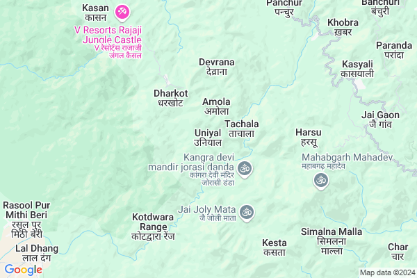
Uniyal
Uniyal Map
EDIT Map
Add Your House
 ..
..
Current Corona Virus Infected Patients Count in Pauri Garhwal District
| City Name | District Name | Total Covid cases |
|---|---|---|
| Dugadda | Pauri Garhwal | 1 |
Locality Name :
Uniyal
( उनियाल )
Block Name : Duggada
District : Pauri Garhwal
State : Uttarakhand
Language : Hindi and Urdu
Current Time 10:27 AM
Date: Monday , Apr 28,2025 (IST)
Time zone: IST (UTC+5:30)
Elevation / Altitude: 369 meters. Above Seal level
Telephone Code / Std Code: 01386
Assembly constituency : Yamkeshwar assembly constituency
Assembly MLA : Renu Bisht
Lok Sabha constituency : Garhwal parliamentary constituency
Parliament MP : Tirath Singh Rawat
Serpanch Name :
Pin Code : 246121
Post Office Name : Bhrigukhal (A)
Main Village Name : Uniyal
Commodities Prices : Haridwar Union Market / Mandi
National Highways Reachable To Uniyal
Nationa High Way :NH534
Nationa High Way :NH534
Rivers Near Uniyal
Pathri Roa
Malin
Pathri Roa
Malin
About Uniyal
Correct below Info and add more info about UniyalUniyal is a small Village/hamlet in Duggada Block in Pauri Garhwal District of Uttarakhand State, India. It comes under Uniyal Panchayath. It is located 53 KM towards west from District head quarters Pauri. 18 KM from Duggada. 68 KM from State capital Dehradun
Uniyal Pin code is 246121 and postal head office is Bhrigukhal (A) .
Ramji Gunth ( 6 KM ) , Kesta ( 7 KM ) , Awai ( 7 KM ) , Kimsar ( 7 KM ) , Simalna Malla ( 9 KM ) are the nearby Villages to Uniyal. Uniyal is surrounded by Duggada Block towards East , Rishikesh Block towards North , Haridwar Block towards west , Bahadrabad Block towards west .
Haridwar , Kotdwara , Rishikesh , Najibabad are the near by Cities to Uniyal.
Demographics of Uniyal
Hindi is the Local Language here.Politics in Uniyal
BJP , INC are the major political parties in this area.Polling Stations /Booths near Uniyal
1)Ghss Timli2)Gps Amaldu
3)Gps Taal
4)Gps Dhari
5)Gjhs Patna K.nan. 2
HOW TO REACH Uniyal
By Rail
There is no railway station near to Uniyal in less than 10 km.Colleges near Uniyal
Dr. B.gopal Reddy Compus Puari Garhwal
Address :
Puriyadang Intercollege
Address :
Government Degree College Chaubattakhal
Address :
Government Inter College Haldukhal
Address :
Goverment Inter Collage Sidhkhal Churani
Address :
Schools near Uniyal
Tcg Public School
Address : simalchaud , dugadda , garhwal , Uttarakhand . PIN- 246149 , Post - Kotdwara
Mk Vn Udayrampur
Address : udayrampur , dugadda , garhwal , Uttarakhand . PIN- 246149 , Post - Kotdwara
Ggic Ghamandpur
Address : nimbu choud , dugadda , garhwal , Uttarakhand . PIN- 246149 , Post - Kotdwara
D.a.v Public School Kotdwar
Address : balbhadrapur , dugadda , garhwal , Uttarakhand . PIN- 246149 , Post - Kotdwara
Govt Health Centers near Uniyal
1) Devli SC , Diwli , Dewli , PS School2) Katghar APHC , Katghar , Katghar , Katghar
3) Katghar SC , Katghar , Katghar , Katghar
Sub Villages in Uniyal
Hospitals in Uniyal,Duggada
Sai Hospital;Meethi Beri Tiraha;
Laldhang Rd; Lal Dhang; Uttarakhand 246763; India
12.3 KM distance Detail
Govt.Ayurvedic Hospital Pokharkhal;Pauri Garhwal
hospital Road;k otali; Uttarakhand 246121; India
16.9 KM distance Detail
more ..
Colleges in Uniyal,Duggada
Kunwer Prabha Public School & degree college
Rasool Pur Mithi Beri; Uttarakhand 246749; India
13.7 KM distance Detail
more ..
Electronic Shops in Uniyal,Duggada
Deepak Mobile Store
Padampur Rd; Ratanpur Sukhro; Balasaur; Kotdwara; Uttarakhand 246149; India
23.0 KM distance Detail
Super Markets in Uniyal,Duggada
Local Parks in Uniyal,Duggada
Rajaji National Park - Wild Brook Retreat
Rajaji National Park; Via Chila; Near Vindhya Wasini Temple; Gohari Range; Bukundi; Uttarakhand 246001; India
16.0 KM distance Detail
Rajaji National Park Shoolin Jungle Lodge
Pauri Garhwal; Uttarakhand 246121; India
16.9 KM distance Detail
RiverStone Camps (Camping and Rafting In Rishikesh)
Nail Gaon; Uttarakhand 246121; India
19.1 KM distance Detail
Governement Offices near Uniyal,Duggada
Freejobaware
Alaknanda Colony Near-Garhwali Tanki;Dhurvpur; Kotdwar; Kotdwara; Uttarakhand 246149; India
21.3 KM distance Detail
Office Of Executive Engineer Rural Work Department Kotdwara
Ekta Puram Colony; Gautam Vihar; Padampur Sukhro; Uttarakhand 246149; India
23.3 KM distance Detail
About Uniyal &
History
How to reach Uniyal
Tourist Places Near By Uniyal
Schools in Uniyal
Colleges in Uniyal
Temperature & weather of Uniyal
places in Uniyal
Uniyal photos
More Information
How to reach Uniyal
Tourist Places Near By Uniyal
Schools in Uniyal
Colleges in Uniyal
Temperature & weather of Uniyal
places in Uniyal
Uniyal photos
More Information
Village Talk
Post News or Events about this Village
Near Cities
Haridwar 17 KM near
Kotdwara 23 KM near
Rishikesh 26 KM near
Najibabad 36 KM near
Haridwar 17 KM near
Kotdwara 23 KM near
Rishikesh 26 KM near
Najibabad 36 KM near
Near By Taluks
Yamkeshwar 11 KM near
Duggada 17 KM near
Rishikesh 26 KM near
Haridwar 28 KM near
Yamkeshwar 11 KM near
Duggada 17 KM near
Rishikesh 26 KM near
Haridwar 28 KM near
Near By Air Ports
Dehra Dun Airport 65 KM near
Muzaffarnagar Airport 98 KM near
Pantnagar Airport 158 KM near
Chandigarh Airport 197 KM near
Dehra Dun Airport 65 KM near
Muzaffarnagar Airport 98 KM near
Pantnagar Airport 158 KM near
Chandigarh Airport 197 KM near
Near By Tourist Places
Haridwar 26 KM near
Rishikesh 27 KM near
Lansdowne 30 KM near
Devprayag 37 KM near
Rajaji National Park 45 KM near
Haridwar 26 KM near
Rishikesh 27 KM near
Lansdowne 30 KM near
Devprayag 37 KM near
Rajaji National Park 45 KM near
Near By Districts
Haridwar 26 KM near
Pauri Garhwal 50 KM near
Tehri Garhwal 61 KM near
Dehradun 67 KM near
Haridwar 26 KM near
Pauri Garhwal 50 KM near
Tehri Garhwal 61 KM near
Dehradun 67 KM near
Near By RailWay Station
Raiwala Junction Rail Way Station 26 KM near
Haridwar Rail Way Station 27 KM near
Raiwala Junction Rail Way Station 26 KM near
Haridwar Rail Way Station 27 KM near