| Home | City Bus | Maps | Villages | Cities | Rail | Tourist Places | School | College | Pin Codes | Corona Cases Count |
| Distance Calculator Bus Services IFSC Codes Trace Mobile Number Weather Search Place Trace IP Available Cash ATM/Banks Locate Polling Booth Report an Error contact People |
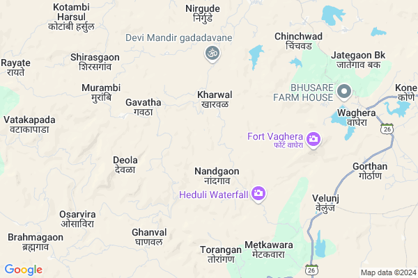
Virnagar
Virnagar Map
EDIT Map
Add Your House
 ..
..
Current Corona Virus Infected Patients Count in Nashik District
| City Name | District Name | Total Covid cases |
|---|---|---|
| Malegaon | Nashik | 46 |
| Nashik District | Nashik | 15 |
| Nashik | Nashik | 4 |
| Nashik Rural | Nashik | 3 |
Locality Name :
Virnagar
( वीरनगर )
Taluka Name : Trimbak
District : Nashik
State : Maharashtra
Region : Khandesh and Northern Maharashtra
Division : Nashik
Language : Marathi and Hindi, Ahirani And Bhili
Current Time 02:28 PM
Date: Friday , Apr 25,2025 (IST)
Time zone: IST (UTC+5:30)
Elevation / Altitude: 591 meters. Above Seal level
Telephone Code / Std Code: 02594
Assembly constituency : Igatpuri assembly constituency
Assembly MLA : Hiraman Bhika Khoskar
Lok Sabha constituency : Nashik parliamentary constituency
Parliament MP : Godse Hemant Tukaram
Serpanch Name :
Pin Code : 422204
Post Office Name : Harsul
Main Village Name : Virnagar
Commodities Prices : Nasik Market / Mandi
Virnagar Live Weather
Temperature: 37.4 °C
scattered clouds
Humidity: 16%
Wind : 5.07 mt/sec towards W
StationName : "Trimbak"
observed on 1 Hours Back
Temperature: 37.4 °C
scattered clouds
Humidity: 16%
Wind : 5.07 mt/sec towards W
StationName : "Trimbak"
observed on 1 Hours Back
Virnagar Weather Forecast for Next 5 days
26-04-2025
25.3°C to 36.5°C
scattered clouds, few clouds, clear sky
25.3°C to 36.5°C
scattered clouds, few clouds, clear sky
27-04-2025
24.2°C to 37.5°C
few clouds, clear sky, scattered clouds, broken clouds, overcast clouds
24.2°C to 37.5°C
few clouds, clear sky, scattered clouds, broken clouds, overcast clouds
28-04-2025
23.9°C to 39.2°C
broken clouds, clear sky, scattered clouds, few clouds
23.9°C to 39.2°C
broken clouds, clear sky, scattered clouds, few clouds
29-04-2025
23.2°C to 38.9°C
clear sky
23.2°C to 38.9°C
clear sky
30-04-2025
23.8°C to 39.6°C
clear sky
23.8°C to 39.6°C
clear sky
National Highways Reachable To Virnagar
Nationa High Way :NH848
Nationa High Way :NH60;NH160
Nationa High Way :NH848
Nationa High Way :NH60;NH160
Rivers Near Virnagar
Sakhal Todi
Alandi
Sakhal Todi
Alandi
About Virnagar
Correct below Info and add more info about VirnagarVirnagar is a small Village/hamlet in Trimbak Taluka in Nashik District of Maharashtra State, India. It comes under Virnagar Panchayath. It belongs to Khandesh and Northern Maharashtra region . It belongs to Nashik Division . It is located 44 KM towards west from District head quarters Nashik. 6 KM from Trimbak. 151 KM from State capital Mumbai
Virnagar Pin code is 422204 and postal head office is Harsul .
Gadadvane ( 4 KM ) , Gavatha ( 4 KM ) , Harsul ( 6 KM ) , Vaghera ( 7 KM ) , Thanapada ( 8 KM ) are the nearby Villages to Virnagar. Virnagar is surrounded by Mokhada Taluka towards South , Peth Taluka towards North , Jawhar Taluka towards west , Kaprada Taluka towards North .
Nashik , Silvassa , Amli , Ozar are the near by Cities to Virnagar.
This Place is in the border of the Nashik District and Thane District. Thane District Mokhada is South towards this place .
Virnagar 2011 Census Details
Virnagar Local Language is Marathi. Virnagar Village Total population is 977 and number of houses are 226. Female Population is 49.6%. Village literacy rate is 52.4% and the Female Literacy rate is 22.7%.
Population
| Census Parameter | Census Data |
| Total Population | 977 |
| Total No of Houses | 226 |
| Female Population % | 49.6 % ( 485) |
| Total Literacy rate % | 52.4 % ( 512) |
| Female Literacy rate | 22.7 % ( 222) |
| Scheduled Tribes Population % | 95.9 % ( 937) |
| Scheduled Caste Population % | 0.1 % ( 1) |
| Working Population % | 59.3 % |
| Child(0 -6) Population by 2011 | 147 |
| Girl Child(0 -6) Population % by 2011 | 51.7 % ( 76) |
Virnagar Census More Deatils.
Politics in Virnagar
MNS , NCP , Shivsena , SHS , INC are the major political parties in this area.Polling Stations /Booths near Virnagar
1)Z. P. Primary School Kharoli South Side East West Building Room No. 12)Z. P. Primary School Murambi (h ) East West Building East Side Room No. 1
3)Z. P. Primary School Kharval East West Building South Side New Building West Side Room No. 1
4)Z. P. Primary School
5)Z.p. Primary School East Side North-south Building R. No. 1 North Side Valvihir
HOW TO REACH Virnagar
By Rail
There is no railway station near to Virnagar in less than 10 km. Igatpuri Rail Way Station (near to Igatpuri) , Atgaon Rail Way Station (near to Trimbak) , Ghoti Rail Way Station (near to Igatpuri) , Nasik Road Rail Way Station (near to Nashik) , Thansit Rail Way Station (near to Trimbak) are the Rail way stations reachable from near by towns.By Road
Nashik , Igatpuri , Trimbak are the nearby by towns to Virnagar having road connectivity to VirnagarColleges near Virnagar
Jvit College Of Arts Science Commarce College Chirapali
Address : Chirapali Saraste Road Near Forest Nurssory .chirapali
National Agriculture College
Address : Near Forest Nurssory Chirapali Saraste Road.
National Agriculture Education Of Information Technology Takeharsh
Address : At Takeharsh, Post Alwand Tal. Trambakeshwar Dist. Nashik
Schools in Virnagar
Z.p.school Mulgaon
Address : virnagar , trimbak , nashik , Maharashtra . PIN- 422204 , Post - Harsul
Govt Health Centers near Virnagar
1) Navedhagur , SC NAVEDHAGUR , NAVEDHAGUR , NAVEDHAGUR2) Jalalpur , SUB CENTER JALALPUR , AT POST JALALPUR , NEAR GRAMPANCHAYAT OFFICE
3) Chandsi , SUB CENTER CHANDSI , AT POST CHANDSI , NEAR GRAMPANCHAYAT OFFICE OPP ZILLHA PARISHAD SCHOOL
Sub Villages in Virnagar
Colleges in Virnagar,Trimbak
Vivekanand Institute Pegalwadi Trimbakeshwar District Nashik
Ghoti Trimbak Rd; Trimbak; Maharashtra 422212; India
20.6 KM distance Detail
more ..
Schools in Virnagar,Trimbak
Zilla Parishad Upper Primary School
Talwade; Trimbak; Trimbakeshwar; Nashik; Maharashtra 422001; India
20.5 KM distance Detail
Electronic Shops in Virnagar,Trimbak
Super Markets in Virnagar,Trimbak
Local Parks in Virnagar,Trimbak
Police Stations near Virnagar,Trimbak
Governement Offices near Virnagar,Trimbak
About Virnagar &
History
How to reach Virnagar
Tourist Places Near By Virnagar
Schools in Virnagar
Colleges in Virnagar
Temperature & weather of Virnagar
places in Virnagar
Virnagar photos
More Information
How to reach Virnagar
Tourist Places Near By Virnagar
Schools in Virnagar
Colleges in Virnagar
Temperature & weather of Virnagar
places in Virnagar
Virnagar photos
More Information
Village Talk
Post News or Events about this Village
Near Cities
Nashik 42 KM near
Silvassa 55 KM near
Amli 55 KM near
Ozar 58 KM near
Nashik 42 KM near
Silvassa 55 KM near
Amli 55 KM near
Ozar 58 KM near
Near By Taluks
Trimbak 6 KM near
Mokhada 25 KM near
Jawhar 28 KM near
Peth 28 KM near
Trimbak 6 KM near
Mokhada 25 KM near
Jawhar 28 KM near
Peth 28 KM near
Near By Air Ports
Gandhinagar Airport 45 KM near
Chhatrapati Shivaji International Airport 135 KM near
Lohegaon Airport 191 KM near
Chikkalthana Airport 231 KM near
Gandhinagar Airport 45 KM near
Chhatrapati Shivaji International Airport 135 KM near
Lohegaon Airport 191 KM near
Chikkalthana Airport 231 KM near
Near By Tourist Places
Trimbakeshwar 18 KM near
Vikramgad 28 KM near
Khodala 32 KM near
Nasik 42 KM near
Igatpuri 46 KM near
Trimbakeshwar 18 KM near
Vikramgad 28 KM near
Khodala 32 KM near
Nasik 42 KM near
Igatpuri 46 KM near
Near By Districts
Nashik 43 KM near
Dadra And Nagar Haveli 56 KM near
Diu 83 KM near
Daman 83 KM near
Nashik 43 KM near
Dadra And Nagar Haveli 56 KM near
Diu 83 KM near
Daman 83 KM near
Near By RailWay Station
Igatpuri Rail Way Station 46 KM near
Nasik Road Rail Way Station 49 KM near
Igatpuri Rail Way Station 46 KM near
Nasik Road Rail Way Station 49 KM near