| Home | City Bus | Maps | Villages | Cities | Rail | Tourist Places | School | College | Pin Codes | Corona Cases Count |
| Distance Calculator Bus Services IFSC Codes Trace Mobile Number Weather Search Place Trace IP Available Cash ATM/Banks Locate Polling Booth Report an Error contact People |
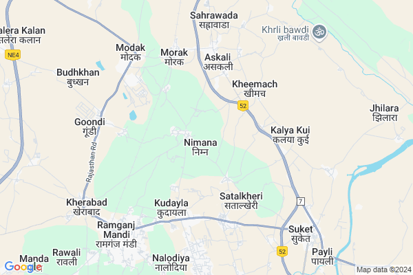
Nimana Map
EDIT Map
Add Your House
 ..
..
Current Corona Virus Infected Patients Count in Kota District
| City Name | District Name | Total Covid cases |
|---|---|---|
| Kota District | Kota | 158 |
Locality Name :
Nimana
( निमाणा )
Tehsil Name : Khairabad
District : Kota
State : Rajasthan
Division : Kota
Language : Rajasthani
Current Time 02:31 PM
Date: Tuesday , Apr 29,2025 (IST)
Time zone: IST (UTC+5:30)
Elevation / Altitude: 358 meters. Above Seal level
Telephone Code / Std Code: 07432
Assembly constituency : Ramganj Mandi assembly constituency
Assembly MLA : Madan Dilawar
Lok Sabha constituency : Kota parliamentary constituency
Parliament MP : OM BIRLA
Serpanch Name :
Pin Code : 326519
Post Office Name : Ram Ganj Mandi
Main Village Name : Nimana
Commodities Prices : Ramgang Mandi(Bapawarkala) Market / Mandi
Rivers Near Nimana
Chambal River :चम्बल
Ahu
Chambal River :चम्बल
Ahu
About Nimana
Correct below Info and add more info about NimanaNimana is a small Village/hamlet in Khairabad Tehsil in Kota District of Rajasthan State, India. It comes under Nimana Panchayath. It belongs to Kota Division . It is located 67 KM towards South from District head quarters Kota. 6 KM from Khairabad. 290 KM from State capital Jaipur
Nimana Pin code is 326519 and postal head office is Ram Ganj Mandi .
Kheemach ( 4 KM ) , Modak Gaon ( 6 KM ) , Salawad Khurd ( 7 KM ) , Suket ( 7 KM ) , Kumbhkot ( 7 KM ) are the nearby Villages to Nimana. Nimana is surrounded by Jhalawar Tehsil towards East , Jhalrapatan Tehsil towards South , Bhanpura Tehsil towards west , Sangod Tehsil towards North .
Ramganj Mandi , Jhalawar , Rawatbhata , Kota are the near by Cities to Nimana.
Nimana 2011 Census Details
Nimana Local Language is Rajasthani. Nimana Village Total population is 1277 and number of houses are 237. Female Population is 48.1%. Village literacy rate is 57.9% and the Female Literacy rate is 23.3%.
Population
| Census Parameter | Census Data |
| Total Population | 1277 |
| Total No of Houses | 237 |
| Female Population % | 48.1 % ( 614) |
| Total Literacy rate % | 57.9 % ( 740) |
| Female Literacy rate | 23.3 % ( 298) |
| Scheduled Tribes Population % | 52.0 % ( 664) |
| Scheduled Caste Population % | 19.8 % ( 253) |
| Working Population % | 49.3 % |
| Child(0 -6) Population by 2011 | 201 |
| Girl Child(0 -6) Population % by 2011 | 46.8 % ( 94) |
Nimana Census More Deatils.
Politics in Nimana
BJP , INC are the major political parties in this area.Polling Stations /Booths near Nimana
1)Govt. Secondary School Dharmpura Room N. 12)Govt.primary School Sureda Room No. 1
3)Govt. Senior Secondary School Near Vagitable Market Ramganjmandi
4)Govt.senior Secondary School Bhanvaria Room N. 1
5)Govt.upper Primary School (sanskrit) Bishanya Khedi Room No. 1
HOW TO REACH Nimana
By Rail
Morak Rail Way Station , Ramganj Mandi Junction Rail Way Station are the very nearby railway stations to Nimana.Colleges near Nimana
Sanskrit Shiksha Shastri College
Address :
Schools in Nimana
G.u.p.s. Nimana
Address : nimana , kherabad , kota , Rajasthan . PIN- 326519 , Post - Ram Ganj Mandi
Govt Health Centers near Nimana
1) Modak , C.H.C. MODAK , NEAR RAILWAY STATION MORAK , DHABDEH ROAD2) Modak Gaon , PHC MODAK GAVE , NEAR PURANI PANCHAYAT , RAMGANJMANDI,KHAIRABAD ROAD
3) Suket , CHC SUKET , JHALWAR ROAD ,
Sub Villages in Nimana
Hospitals in Nimana,Khairabad
Samudayik Swasthya Kendra
Bhilwara to Modak via Mandalgarh Salawatia Bhensrogarh; Morak; Rajasthan 326517; India
5.1 KM distance Detail
more ..
Petrol Bunks in Nimana,Khairabad
Shakti Service Station & HOTEL Chandra Midway And Restraunt
MDR7; Hirya Kheri; Rajasthan 326517; India
3.4 KM distance Detail
Chaudhary Petrol Pump Reliance Petroleum
Khemaj; Kota; NH-12; Kota Road; Kota; Kota; Rajasthan 326001; India
3.4 KM distance Detail
Ambika Indian Oil Petrol Pump
Khemaj; Kota; NH-12; Kota Road; Kota; Kota; Rajasthan 326001; India
3.5 KM distance Detail
more ..
Colleges in Nimana,Khairabad
Government College Ramganj Mandi
Near spice park; nimana road; Ramganj Mandi; Rajasthan; India
2.2 KM distance Detail
more ..
Schools in Nimana,Khairabad
Krishna Career Institute Hiriyakheri
Ramganj Mandi Rd; Beedgaon; Rajasthan 458775; India
3.3 KM distance Detail
Government Higher Primary School
Suket; Kota; NH-12; Kota Road; Kota; Kota; Rajasthan 326001; India
3.4 KM distance Detail
Super Markets in Nimana,Khairabad
porwal General Store
Pannalal chauraha bazar no.3; Ramganj Mandi; Rajasthan; India
7.6 KM distance Detail
Police Stations near Nimana,Khairabad
Police Station
Bazar No. 1; RJ SH 9B; Gundi; Ramganj Mandi; Rajasthan 326519; India
7.6 KM distance Detail
About Nimana &
History
How to reach Nimana
Tourist Places Near By Nimana
Schools in Nimana
Colleges in Nimana
Temperature & weather of Nimana
places in Nimana
Nimana photos
More Information
How to reach Nimana
Tourist Places Near By Nimana
Schools in Nimana
Colleges in Nimana
Temperature & weather of Nimana
places in Nimana
Nimana photos
More Information
Village Talk
Post News or Events about this Village
Near Cities
Ramganj Mandi 8 KM near
Jhalawar 22 KM near
Rawatbhata 55 KM near
Kota 64 KM near
Ramganj Mandi 8 KM near
Jhalawar 22 KM near
Rawatbhata 55 KM near
Kota 64 KM near
Near By Taluks
Khairabad 6 KM near
Jhalawar 22 KM near
Jhalrapatan 30 KM near
Bhanpura 37 KM near
Khairabad 6 KM near
Jhalawar 22 KM near
Jhalrapatan 30 KM near
Bhanpura 37 KM near
Near By Air Ports
Bhopal Airport 232 KM near
Dabok Airport 237 KM near
Indore Airport 245 KM near
Sanganeer Airport 266 KM near
Bhopal Airport 232 KM near
Dabok Airport 237 KM near
Indore Airport 245 KM near
Sanganeer Airport 266 KM near
Near By Tourist Places
Jhalawar 16 KM near
Kota 62 KM near
Bijolia 94 KM near
Bundi 101 KM near
Neemuch 129 KM near
Jhalawar 16 KM near
Kota 62 KM near
Bijolia 94 KM near
Bundi 101 KM near
Neemuch 129 KM near
Near By Districts
Jhalawar 22 KM near
Kota 64 KM near
Baran 77 KM near
Bundi 99 KM near
Jhalawar 22 KM near
Kota 64 KM near
Baran 77 KM near
Bundi 99 KM near
Near By RailWay Station
Morak Rail Way Station 5.4 KM near
Ramganj Mandi Junction Rail Way Station 8.5 KM near
Bhawani Mandi Rail Way Station 38 KM near
Morak Rail Way Station 5.4 KM near
Ramganj Mandi Junction Rail Way Station 8.5 KM near
Bhawani Mandi Rail Way Station 38 KM near