| Home | City Bus | Maps | Villages | Cities | Rail | Tourist Places | School | College | Pin Codes | Corona Cases Count |
| Distance Calculator Bus Services IFSC Codes Trace Mobile Number Weather Search Place Trace IP Available Cash ATM/Banks Locate Polling Booth Report an Error contact People |
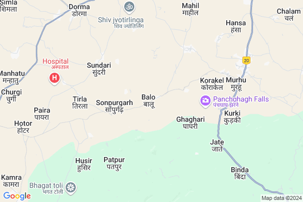
Balo Map
EDIT Map
Add Your House
 ..
..
Current Corona Virus Infected Patients Count in Khunti District
| City Name | District Name | Total Covid cases |
|---|
Locality Name :
Balo
( बालो )
Block Name : Murhu
District : Khunti
State : Jharkhand
Language : Hindi and Santali
Current Time 12:30 PM
Date: Wednesday , Feb 05,2025 (IST)
Time zone: IST (UTC+5:30)
Elevation / Altitude: 657 meters. Above Seal level
Telephone Code / Std Code: 06528
Assembly constituency : Khunti assembly constituency
Assembly MLA : NILKANTH SINGH MUNDA
Lok Sabha constituency : Khunti parliamentary constituency
Parliament MP : ARJUN MUNDA
Serpanch Name :
Pin Code : 835216
Post Office Name : Murhu
Main Village Name : Balo
Commodities Prices : Khunti Market / Mandi
Balo Live Weather
Temperature: 31.8 °C
clear sky
Humidity: 21%
Wind : 3.84 mt/sec towards W
StationName : "Khunti"
observed on 23 Mins Back
Temperature: 31.8 °C
clear sky
Humidity: 21%
Wind : 3.84 mt/sec towards W
StationName : "Khunti"
observed on 23 Mins Back
Balo Weather Forecast for Next 5 days
06-02-2025
19.1°C to 32.8°C
clear sky, scattered clouds
19.1°C to 32.8°C
clear sky, scattered clouds
07-02-2025
16.6°C to 30.6°C
clear sky, scattered clouds, few clouds
16.6°C to 30.6°C
clear sky, scattered clouds, few clouds
08-02-2025
14.2°C to 31.0°C
clear sky
14.2°C to 31.0°C
clear sky
09-02-2025
12.9°C to 29.8°C
clear sky
12.9°C to 29.8°C
clear sky
10-02-2025
14.0°C to 31.7°C
clear sky
14.0°C to 31.7°C
clear sky
Rivers Near Balo
Koel River
South Koel River
Koel River
South Koel River
About Balo
Correct below Info and add more info about BaloBalo is a small Village/hamlet in Murhu Block in Khunti District of Jharkhand State, India. It comes under Balo Panchayath. It is located 17 KM towards South from District head quarters Khunti. 9 KM from Murhu. 52 KM from State capital Ranchi
Balo Pin code is 835216 and postal head office is Murhu .
Murhu ( 7 KM ) , Husir ( 7 KM ) , Hansa ( 9 KM ) , Binda ( 9 KM ) , Rumutkel ( 10 KM ) are the nearby Villages to Balo. Balo is surrounded by Torpa Block towards west , Karra Block towards North , Bandgaon Block towards South , Khunti Block towards North .
Khunti , Ranchi , Barughutu , Chakradharpur are the near by Cities to Balo.
This Place is in the border of the Khunti District and West Singhbhum District. West Singhbhum District Bandgaon is South towards this place .
Balo 2011 Census Details
Balo Local Language is Hindi. Balo Village Total population is 542 and number of houses are 94. Female Population is 48.2%. Village literacy rate is 47.6% and the Female Literacy rate is 17.5%.
Population
| Census Parameter | Census Data |
| Total Population | 542 |
| Total No of Houses | 94 |
| Female Population % | 48.2 % ( 261) |
| Total Literacy rate % | 47.6 % ( 258) |
| Female Literacy rate | 17.5 % ( 95) |
| Scheduled Tribes Population % | 85.4 % ( 463) |
| Scheduled Caste Population % | 0.0 % ( 0) |
| Working Population % | 49.8 % |
| Child(0 -6) Population by 2011 | 93 |
| Girl Child(0 -6) Population % by 2011 | 46.2 % ( 43) |
Balo Census More Deatils.
Politics in Balo
Bharatiya Janata Party , BJP , JMM , JKP , INC are the major political parties in this area.Polling Stations /Booths near Balo
1)Govt. Upgraded Middle School Sawra2)Primary School Kasira
3)G.e.l. Mission Middle School Bichana
4)Primary School Chalam
5)Primary School Timra
HOW TO REACH Balo
By Rail
There is no railway station near to Balo in less than 10 km.Colleges near Balo
Birsa Collage Khunti
Address :
Schools near Balo
Utkratmic Prathmic Vidyalay Dulwa
Address : Khunti,Dulwa
Govt Health Centers near Balo
1) HSC BABNI , HSC BAMHNI , VILLAGE BAMHNI , BLOCK MURHU2) HSC SUNDARI , SUNDARI , SUNDARI ,
3) HSC TIRLA , TIRLA , TIRLA ,
Sub Villages in Balo
Colleges in Balo,Murhu
Madrsa Madinatul-Uloom
Liyaqat Ali Ln; Jannat Ganar; Khunti; Jharkhand 835210; India
18.2 KM distance Detail
Jharkhand Raksha Shakti University
Vill; Idri; Karra Rd; Khunti; Jharkhand 835210; India
20.0 KM distance Detail
more ..
Schools in Balo,Murhu
KGBV Murhu
Kasturba Gandhi; Sector 2; Bokaro Steel City; Jharkhand 827001; India
6.7 KM distance Detail
Super Markets in Balo,Murhu
Debi Krishi Beej Bhandar
Khunti - Simdega Road; Dorma; Jharkhand 835227; India
9.8 KM distance Detail
Police Stations near Balo,Murhu
Murhu Police Station.
National Highway 75; Dudri; Murhu; Jharkhand 835216; India
7.3 KM distance Detail
Governement Offices near Balo,Murhu
BLOCK DEVELOPMENT OFFICE;MURHU
National Highway 75; Dudri; Murhu; Jharkhand 835216; India
7.2 KM distance Detail
About Balo &
History
How to reach Balo
Tourist Places Near By Balo
Schools in Balo
Colleges in Balo
Temperature & weather of Balo
places in Balo
Balo photos
More Information
How to reach Balo
Tourist Places Near By Balo
Schools in Balo
Colleges in Balo
Temperature & weather of Balo
places in Balo
Balo photos
More Information
Village Talk
Post News or Events about this Village
Near Cities
Khunti 16 KM near
Ranchi 49 KM near
Barughutu 55 KM near
Chakradharpur 57 KM near
Khunti 16 KM near
Ranchi 49 KM near
Barughutu 55 KM near
Chakradharpur 57 KM near
Near By Taluks
Murhu 8 KM near
Torpa 11 KM near
Bandgaon 24 KM near
Karra 24 KM near
Murhu 8 KM near
Torpa 11 KM near
Bandgaon 24 KM near
Karra 24 KM near
Near By Air Ports
Ranchi Airport 47 KM near
Gaya Airport 225 KM near
Patna Airport 329 KM near
Bhubaneswar Airport 342 KM near
Ranchi Airport 47 KM near
Gaya Airport 225 KM near
Patna Airport 329 KM near
Bhubaneswar Airport 342 KM near
Near By Tourist Places
Chotanagpur 25 KM near
Dassam Falls 44 KM near
Ranchi 50 KM near
Gumla 79 KM near
Lohardaga 85 KM near
Chotanagpur 25 KM near
Dassam Falls 44 KM near
Ranchi 50 KM near
Gumla 79 KM near
Lohardaga 85 KM near
Near By Districts
Khunti 17 KM near
Ranchi 49 KM near
Gumla 78 KM near
West Singhbhum 83 KM near
Khunti 17 KM near
Ranchi 49 KM near
Gumla 78 KM near
West Singhbhum 83 KM near
Near By RailWay Station
Hatia Rail Way Station 45 KM near
Ranchi Junction Rail Way Station 51 KM near
Hatia Rail Way Station 45 KM near
Ranchi Junction Rail Way Station 51 KM near