| Home | City Bus | Maps | Villages | Cities | Rail | Tourist Places | School | College | Pin Codes | Corona Cases Count |
| Distance Calculator Bus Services IFSC Codes Trace Mobile Number Weather Search Place Trace IP Available Cash ATM/Banks Locate Polling Booth Report an Error contact People |
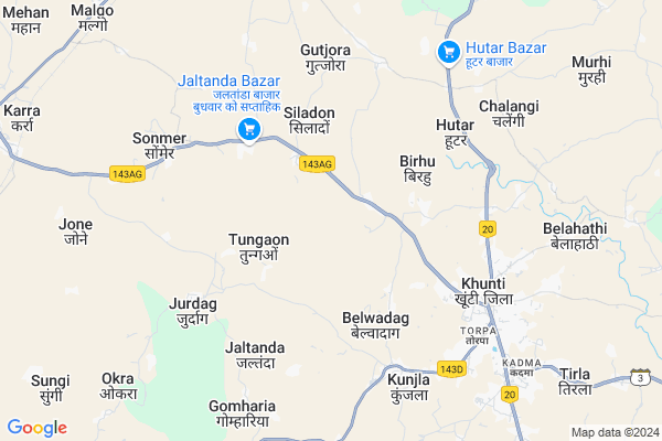
Chiruhatu Map
EDIT Map
Add Your House
 ..
..
Current Corona Virus Infected Patients Count in Khunti District
| City Name | District Name | Total Covid cases |
|---|
Locality Name :
Chiruhatu
( चिरूहतु )
Block Name : Khunti
District : Khunti
State : Jharkhand
Language : Hindi and Santali
Current Time 10:14 AM
Date: Wednesday , Feb 05,2025 (IST)
Time zone: IST (UTC+5:30)
Elevation / Altitude: 657 meters. Above Seal level
Telephone Code / Std Code: 06528
Assembly constituency : Khunti assembly constituency
Assembly MLA : NILKANTH SINGH MUNDA
Lok Sabha constituency : Khunti parliamentary constituency
Parliament MP : ARJUN MUNDA
Serpanch Name :
Pin Code : 835210
Post Office Name : Khunti
Main Village Name : Chiruhatu
Commodities Prices : Khunti Market / Mandi
Rivers Near Chiruhatu
Sobha
Kanchi
Sobha
Kanchi
About Chiruhatu
Correct below Info and add more info about ChiruhatuChiruhatu is a small Village/hamlet in Khunti Block in Khunti District of Jharkhand State, India. It comes under Chiruhatu Panchayath. It is located 6 KM towards west from District head quarters Khunti. 15 KM from Khunti. 33 KM from State capital Ranchi
Chiruhatu Pin code is 835210 and postal head office is Khunti .
Gutjora ( 6 KM ) , Kunjla ( 6 KM ) , Torpa ( 7 KM ) , Kudlum ( 7 KM ) , Bichna ( 8 KM ) are the nearby Villages to Chiruhatu. Chiruhatu is surrounded by Khunti Block towards East , Murhu Block towards South , Torpa Block towards South , Namkum Block towards North .
Khunti , Ranchi , Barughutu , Patratu are the near by Cities to Chiruhatu.
Chiruhatu 2011 Census Details
Chiruhatu Local Language is Hindi. Chiruhatu Village Total population is 445 and number of houses are 89. Female Population is 51.2%. Village literacy rate is 48.1% and the Female Literacy rate is 19.1%.
Population
| Census Parameter | Census Data |
| Total Population | 445 |
| Total No of Houses | 89 |
| Female Population % | 51.2 % ( 228) |
| Total Literacy rate % | 48.1 % ( 214) |
| Female Literacy rate | 19.1 % ( 85) |
| Scheduled Tribes Population % | 93.5 % ( 416) |
| Scheduled Caste Population % | 3.4 % ( 15) |
| Working Population % | 77.8 % |
| Child(0 -6) Population by 2011 | 91 |
| Girl Child(0 -6) Population % by 2011 | 54.9 % ( 50) |
Chiruhatu Census More Deatils.
Politics in Chiruhatu
Bharatiya Janata Party , BJP , JMM , JKP , INC are the major political parties in this area.Polling Stations /Booths near Chiruhatu
1)Community Building Pidihatu2)Primary School Jamuadag
3)Panchayat Building Bamhani
4)Primary School Bala
5)Middle School Maranghada
HOW TO REACH Chiruhatu
By Rail
There is no railway station near to Chiruhatu in less than 10 km.Colleges near Chiruhatu
St Joseph Intermediate College,torpa
Address :
Birsa Collage Khunti
Address :
Schools near Chiruhatu
Govt Health Centers near Chiruhatu
1) HSC REWA , REWA , REWA ,2) DIST HOSPITAL KHUNTI , , ,
3) PHC BIRBANKI , , ,
Sub Villages in Chiruhatu
Hospitals in Chiruhatu,Khunti
Daya Sagar Hospital Khunti
Jharkhand State Highway 3; Jojo Toli; Hitutola; Jharkhand 835216; India
7.2 KM distance Detail
VISNU SANJIVINI
Tamar - Khunti - Kolebira Road; Gomharia; Jharkhand 835216; India
9.1 KM distance Detail
more ..
Colleges in Chiruhatu,Khunti
Jharkhand Raksha Shakti University
Vill; Idri; Karra Rd; Khunti; Jharkhand 835210; India
2.2 KM distance Detail
Maa Para Medical Institute
Near Shiv Mandir; Namkum Basti; Khunti-Ranchi Road; National Highway 23; Jharkhand 835210; India
5.8 KM distance Detail
Madrsa Madinatul-Uloom
Liyaqat Ali Ln; Jannat Ganar; Khunti; Jharkhand 835210; India
5.9 KM distance Detail
Patel B.Ed College
Behind- Kumar Pharma; 1st Floor; Main Road; Hinoo Chowk; Lodhma; Ranchi; Jharkhand 834004; India
18.1 KM distance Detail
more ..
Electronic Shops in Chiruhatu,Khunti
Komal Printing Press Hardag
Gumla - Khunti - Ranchi Road; Jojo Toli; Hardag; Jharkhand 835210; India
7.1 KM distance Detail
Super Markets in Chiruhatu,Khunti
Debi Krishi Beej Bhandar
Khunti - Simdega Road; Dorma; Jharkhand 835227; India
13.9 KM distance Detail
Police Stations near Chiruhatu,Khunti
Lodhma Police Station
Near Government School; Main Road; Kurse; Ranchi; Jharkhand 834004; India
18.3 KM distance Detail
Murhu Police Station.
National Highway 75; Dudri; Murhu; Jharkhand 835216; India
19.0 KM distance Detail
Governement Offices near Chiruhatu,Khunti
BLOCK DEVELOPMENT OFFICE;MURHU
National Highway 75; Dudri; Murhu; Jharkhand 835216; India
19.0 KM distance Detail
About Chiruhatu &
History
How to reach Chiruhatu
Tourist Places Near By Chiruhatu
Schools in Chiruhatu
Colleges in Chiruhatu
Temperature & weather of Chiruhatu
places in Chiruhatu
Chiruhatu photos
More Information
How to reach Chiruhatu
Tourist Places Near By Chiruhatu
Schools in Chiruhatu
Colleges in Chiruhatu
Temperature & weather of Chiruhatu
places in Chiruhatu
Chiruhatu photos
More Information
Village Talk
Post News or Events about this Village
Near Cities
Khunti 6 KM near
Ranchi 31 KM near
Barughutu 59 KM near
Patratu 68 KM near
Khunti 6 KM near
Ranchi 31 KM near
Barughutu 59 KM near
Patratu 68 KM near
Near By Taluks
Karra 13 KM near
Khunti 14 KM near
Murhu 18 KM near
Torpa 23 KM near
Karra 13 KM near
Khunti 14 KM near
Murhu 18 KM near
Torpa 23 KM near
Near By Air Ports
Ranchi Airport 29 KM near
Gaya Airport 207 KM near
Patna Airport 311 KM near
Bhubaneswar Airport 361 KM near
Ranchi Airport 29 KM near
Gaya Airport 207 KM near
Patna Airport 311 KM near
Bhubaneswar Airport 361 KM near
Near By Tourist Places
Chotanagpur 27 KM near
Ranchi 31 KM near
Dassam Falls 33 KM near
Lohardaga 75 KM near
Gumla 79 KM near
Chotanagpur 27 KM near
Ranchi 31 KM near
Dassam Falls 33 KM near
Lohardaga 75 KM near
Gumla 79 KM near
Near By Districts
Khunti 6 KM near
Ranchi 31 KM near
Ramgarh 72 KM near
Lohardaga 75 KM near
Khunti 6 KM near
Ranchi 31 KM near
Ramgarh 72 KM near
Lohardaga 75 KM near
Near By RailWay Station
Hatia Rail Way Station 27 KM near
Ranchi Junction Rail Way Station 33 KM near
Hatia Rail Way Station 27 KM near
Ranchi Junction Rail Way Station 33 KM near