| Home | City Bus | Maps | Villages | Cities | Rail | Tourist Places | School | College | Pin Codes | Corona Cases Count |
| Distance Calculator Bus Services IFSC Codes Trace Mobile Number Weather Search Place Trace IP Available Cash ATM/Banks Locate Polling Booth Report an Error contact People |
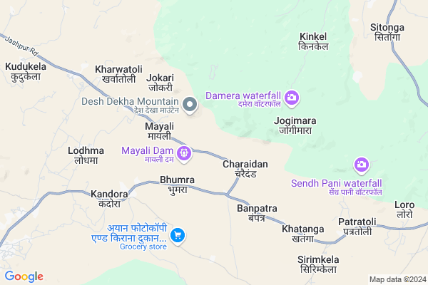
Mayali
Mayali Map
EDIT Map
Add Your House
 ..
..
Current Corona Virus Infected Patients Count in Jashpur District
| City Name | District Name | Total Covid cases |
|---|
Locality Name :
Mayali
( मायली )
Tehsil Name : Kunkuri
District : Jashpur
State : Chattisgarh
Language : Chhattisgarhi and Hindi
Current Time 05:57 AM
Date: Saturday , Apr 26,2025 (IST)
Time zone: IST (UTC+5:30)
Elevation / Altitude: 619 meters. Above Seal level
Telephone Code / Std Code: 07764
Assembly constituency : Kunkuri assembly constituency
Assembly MLA : Vishnu Deo Sai
Lok Sabha constituency : Raigarh parliamentary constituency
Parliament MP : GOMATI SAI
Serpanch Name :
Pin Code : 496334
Post Office Name : Duldula
Main Village Name : Mayali
Alternate Village Name : MAYALI
Commodities Prices : Kunkuri Market / Mandi
Rivers Near Mayali
Girma
Bahri
Girma
Bahri
About Mayali
Correct below Info and add more info about MayaliMayali is a small Village/hamlet in Kunkuri Tehsil in Jashpur District of Chattisgarh State, India. It comes under Mayali Panchayath. It is located 14 KM towards South from District head quarters Jashpur Nagar. 12 KM from Kunkuri. 354 KM from State capital Raipur
Mayali Pin code is 496334 and postal head office is Duldula .
Jokary ( 3 KM ) , Keradih ( 4 KM ) , Kamtara ( 4 KM ) , Raikera ( 5 KM ) , Khatanga ( 5 KM ) are the nearby Villages to Mayali. Mayali is surrounded by Duldula Tehsil towards South , Jashpur Tehsil towards East , Manora Tehsil towards North , Kurdeg Tehsil towards South .
Jashpurnagar , Simdega , Gumla , Sundargarh are the near by Cities to Mayali.
Mayali 2011 Census Details
Mayali Local Language is Chhattisgarhi. Mayali Village Total population is 591 and number of houses are 138. Female Population is 49.2%. Village literacy rate is 62.9% and the Female Literacy rate is 28.1%.
Population
| Census Parameter | Census Data |
| Total Population | 591 |
| Total No of Houses | 138 |
| Female Population % | 49.2 % ( 291) |
| Total Literacy rate % | 62.9 % ( 372) |
| Female Literacy rate | 28.1 % ( 166) |
| Scheduled Tribes Population % | 47.9 % ( 283) |
| Scheduled Caste Population % | 0.0 % ( 0) |
| Working Population % | 70.4 % |
| Child(0 -6) Population by 2011 | 76 |
| Girl Child(0 -6) Population % by 2011 | 46.1 % ( 35) |
Mayali Census More Deatils.
Politics in Mayali
Bharatiya Janata Party , BJP , INC are the major political parties in this area.Polling Stations /Booths near Mayali
1)Mauhadih2)Darakhrika
3)Chanpatoli
4)Kersai ~2
5)Bhalumunda
HOW TO REACH Mayali
By Rail
There is no railway station near to Mayali in less than 10 km.Colleges near Mayali
Government Girls College, Kansabel
Address : Church Road, Near High School
New Government College Kansabel
Address :
Govt. Vbsd Girls College Jashpur Nagar
Address : Major-priti Road, Basant Vihar, Jashpur
Schools in Mayali
Twd. Ps. Mayali
Address : mayali , kunkuri , jashpur , Chattisgarh . PIN- 496334 , Post - Duldula
Govt Health Centers near Mayali
1) SHC Kere , SHC Kere , vill- kere ,2) SHC Devbora , SHC Devbora , Devbora , Devbora
3) SHC Charaidand , sub helthe center , charidand teh.duldula , charaidnad
Sub Villages in Mayali
Petrol Bunks in Mayali,Kunkuri
Kamla Fuel Center
Jashpur Nagar Hwy Marg; Khatanga; Chhattisgarh 496334; India
7.3 KM distance Detail
Indian Oil Petrol Pump
Mahua Toli; Jashpur; NH-78; Ranchi Road; Kunkuri; Kunkuri; Chhattisgarh 496331; India
8.5 KM distance Detail
more ..
Colleges in Mayali,Kunkuri
Government Industrial Training Institute Hostel
Saliatoli;; Chhattisgarh 496225; India
11.7 KM distance Detail
more ..
About Mayali &
History
How to reach Mayali
Tourist Places Near By Mayali
Schools in Mayali
Colleges in Mayali
Temperature & weather of Mayali
places in Mayali
Mayali photos
More Information
How to reach Mayali
Tourist Places Near By Mayali
Schools in Mayali
Colleges in Mayali
Temperature & weather of Mayali
places in Mayali
Mayali photos
More Information
Village Talk
Post News or Events about this Village
Near Cities
Jashpurnagar 17 KM near
Simdega 54 KM near
Gumla 63 KM near
Sundargarh 83 KM near
Jashpurnagar 17 KM near
Simdega 54 KM near
Gumla 63 KM near
Sundargarh 83 KM near
Near By Taluks
Kunkuri 12 KM near
Duldula 13 KM near
Jashpur 21 KM near
Manora 28 KM near
Kunkuri 12 KM near
Duldula 13 KM near
Jashpur 21 KM near
Manora 28 KM near
Near By Air Ports
Ranchi Airport 158 KM near
Gaya Airport 263 KM near
Raipur Airport 334 KM near
Varanasi Airport 358 KM near
Ranchi Airport 158 KM near
Gaya Airport 263 KM near
Raipur Airport 334 KM near
Varanasi Airport 358 KM near
Near By Tourist Places
Jashpur 15 KM near
Simdega 55 KM near
Gumla 63 KM near
Netarhat 88 KM near
Lohardaga 106 KM near
Jashpur 15 KM near
Simdega 55 KM near
Gumla 63 KM near
Netarhat 88 KM near
Lohardaga 106 KM near
Near By Districts
Jashpur 14 KM near
Simdega 53 KM near
Gumla 63 KM near
Sundargarh 84 KM near
Jashpur 14 KM near
Simdega 53 KM near
Gumla 63 KM near
Sundargarh 84 KM near
Near By RailWay Station
Bamra Rail Way Station 95 KM near
Rajgangpur Rail Way Station 96 KM near
Bamra Rail Way Station 95 KM near
Rajgangpur Rail Way Station 96 KM near