| Home | City Bus | Maps | Villages | Cities | Rail | Tourist Places | School | College | Pin Codes | Corona Cases Count |
| Distance Calculator Bus Services IFSC Codes Trace Mobile Number Weather Search Place Trace IP Available Cash ATM/Banks Locate Polling Booth Report an Error contact People |
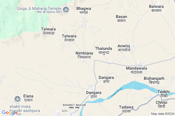
Nimblana Map
EDIT Map
Add Your House
 ..
..
Current Corona Virus Infected Patients Count in Jalore District
| City Name | District Name | Total Covid cases |
|---|
Locality Name :
Nimblana
( निंबलाना )
Tehsil Name : Sayla
District : Jalore
State : Rajasthan
Division : Jodhpur
Language : Hindi and Rajasthani
Current Time 12:19 PM
Date: Monday , Apr 28,2025 (IST)
Time zone: IST (UTC+5:30)
Elevation / Altitude: 140 meters. Above Seal level
Telephone Code / Std Code: 02977
Assembly constituency : Jalore assembly constituency
Assembly MLA : Jogeshwar Garg
Lok Sabha constituency : Jalore parliamentary constituency
Parliament MP : Devaji Patel
Serpanch Name :
Pin Code : 343042
Post Office Name : Mandwala
Main Village Name : Nimblana
Commodities Prices : Jalore Market / Mandi
Edit below overview about Nimblana
Edit below overview about Nimblana
OverView of Nimblana
There are 13-14 house of jain community.there is also a ancient jain temple which was built 100 or more years ago.Edit below overview about Nimblana
National Highways Reachable To Nimblana
Nationa High Way :NH325
Nationa High Way :NH325
Rivers Near Nimblana
Jawai
Sukri (Sayala)
Jawai
Sukri (Sayala)
About Nimblana
Nimblana is a small Village/hamlet in Sayla Tehsil in Jalore District of Rajasthan State, India. It comes under Nimblana Panchayath. It belongs to Jodhpur Division . It is located 23 KM towards west from District head quarters Jalore. 26 KM from Sayla. 436 KM from State capital Jaipur
Nimblana Pin code is 343042 and postal head office is Mandwala .
Elana ( 9 KM ) , Bishangarh ( 10 KM ) , Keshwana ( 10 KM ) , Balwara ( 11 KM ) , Teekhi ( 11 KM ) are the nearby Villages to Nimblana. Nimblana is surrounded by Siwana Tehsil towards North , Jalore Tehsil towards East , Ahore Tehsil towards East , Bhinmal Tehsil towards South .
Jalore , Bhinmal , Sumerpur , Sheoganj are the near by Cities to Nimblana.
Nimblana 2011 Census Details
Nimblana Local Language is Hindi. Nimblana Village Total population is 2491 and number of houses are 453. Female Population is 49.0%. Village literacy rate is 42.2% and the Female Literacy rate is 14.5%.
Population
| Census Parameter | Census Data |
| Total Population | 2491 |
| Total No of Houses | 453 |
| Female Population % | 49.0 % ( 1220) |
| Total Literacy rate % | 42.2 % ( 1051) |
| Female Literacy rate | 14.5 % ( 360) |
| Scheduled Tribes Population % | 14.0 % ( 349) |
| Scheduled Caste Population % | 23.2 % ( 578) |
| Working Population % | 53.2 % |
| Child(0 -6) Population by 2011 | 454 |
| Girl Child(0 -6) Population % by 2011 | 44.1 % ( 200) |
Nimblana Census More Deatils.
Politics in Nimblana
Bharatiya Janata Party , BJP , INC are the major political parties in this area.Polling Stations /Booths near Nimblana
1)Govt. Sec. School Left Room Dangra2)Govt. Ups Raniwada Kaba
3)Govt. Sec. School Tura Right Room
4)Govt. Sec. School Left Room Dadal
5)Govt. Ups Tadwa
HOW TO REACH Nimblana
By Rail
There is no railway station near to Nimblana in less than 10 km.Colleges near Nimblana
Sayala College Sayala
Address : Sayala
Kanaram Gevarammali Junior Digri College Asana
Address :
Nitmt Institute Of Agri. Business
Address : Nitmt Institute Of Agri. Business & Rural Mgt. Col
Schools in Nimblana
G.sec.nimblana
Address : nimblana , sayla , jalor , Rajasthan . PIN- 343021 , Post - Ummedabad
Govt Health Centers near Nimblana
1) Telwara , V/P TELWADA , TEH SIWANA , DIST BARMER2) Bhagwa , V/P BHAGWA , TEH SIWANA , DIST BARMER
3) Mandawala , Mandawala , Mandawala ,
Sub Villages in Nimblana
Hospitals in Nimblana,Sayla
KC Chhazed Jain Hospital
Sayala; Jalore; SH-16; Jalore Road; Jalore; Jalore; Rajasthan 343001; India
9.4 KM distance Detail
more ..
Petrol Bunks in Nimblana,Sayla
Shiv Shakti Petroleum Essar Oil Petrol Pump
Jalore; SH-38; Jalore Road; Jalore; Jalore; Rajasthan 343001; India
13.5 KM distance Detail
more ..
Electronic Shops in Nimblana,Sayla
Choudhary Moter Parts
Gudamalani - Bagora - Sayala - Jalor - Bhinmal Rd; Ummedabad; Rajasthan 343021; India
8.5 KM distance Detail
Super Markets in Nimblana,Sayla
Shree Ramdev Ganeral Store
Gudamalani - Bagora - Sayala - Jalor - Bhinmal Road; Ummedabad; Rajasthan 343021; India
8.6 KM distance Detail
Police Stations near Nimblana,Sayla
Police Station
Gudamalani - Bagora - Sayala - Jalor - Bhinmal Rd; Ummedabad; Rajasthan 343021; India
8.3 KM distance Detail
Governement Offices near Nimblana,Sayla
Atal Seva Center
Saayala; Jalore; SH-16; Jalore Road; Jalore; Jalore; Rajasthan 343001; India
9.4 KM distance Detail
Atal Seva Center
Sayala; Jalore; SH-16; Jalore Road; Jalore; Jalore; Rajasthan 343001; India
9.6 KM distance Detail
About Nimblana &
History
How to reach Nimblana
Tourist Places Near By Nimblana
Schools in Nimblana
Colleges in Nimblana
Temperature & weather of Nimblana
places in Nimblana
Nimblana photos
More Information
How to reach Nimblana
Tourist Places Near By Nimblana
Schools in Nimblana
Colleges in Nimblana
Temperature & weather of Nimblana
places in Nimblana
Nimblana photos
More Information
Village Talk
Post News or Events about this Village
Near Cities
Jalore 22 KM near
Bhinmal 58 KM near
Sumerpur 78 KM near
Sheoganj 78 KM near
Jalore 22 KM near
Bhinmal 58 KM near
Sumerpur 78 KM near
Sheoganj 78 KM near
Near By Taluks
Sayla 25 KM near
Siwana 28 KM near
Jalore 29 KM near
Ahore 47 KM near
Sayla 25 KM near
Siwana 28 KM near
Jalore 29 KM near
Ahore 47 KM near
Near By Air Ports
Jodhpur Airport 122 KM near
Dabok Airport 191 KM near
Jaisalmer Airport 253 KM near
Ahmedabad Airport 296 KM near
Jodhpur Airport 122 KM near
Dabok Airport 191 KM near
Jaisalmer Airport 253 KM near
Ahmedabad Airport 296 KM near
Near By Tourist Places
Jalore 21 KM near
Sirohi 100 KM near
Mount Abu 109 KM near
Jodhpur 121 KM near
Barmer 127 KM near
Jalore 21 KM near
Sirohi 100 KM near
Mount Abu 109 KM near
Jodhpur 121 KM near
Barmer 127 KM near
Near By Districts
Jalore 21 KM near
Sirohi 82 KM near
Pali 105 KM near
Jodhpur 121 KM near
Jalore 21 KM near
Sirohi 82 KM near
Pali 105 KM near
Jodhpur 121 KM near
Near By RailWay Station
Samdari Junction Rail Way Station 51 KM near
Balotra Rail Way Station 54 KM near
Samdari Junction Rail Way Station 51 KM near
Balotra Rail Way Station 54 KM near