| Home | City Bus | Maps | Villages | Cities | Rail | Tourist Places | School | College | Pin Codes | Corona Cases Count |
| Distance Calculator Bus Services IFSC Codes Trace Mobile Number Weather Search Place Trace IP Available Cash ATM/Banks Locate Polling Booth Report an Error contact People |
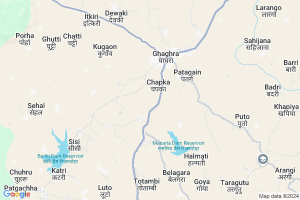
Ludgo Map
EDIT Map
Add Your House
 ..
..
Current Corona Virus Infected Patients Count in Gumla District
| City Name | District Name | Total Covid cases |
|---|
Locality Name :
Ludgo
( लुङ्गो )
Block Name : Ghaghra
District : Gumla
State : Jharkhand
Language : Nagpuri and Hindi, Oriya, Bihari, Kurukh.
Current Time 10:27 AM
Date: Monday , Apr 28,2025 (IST)
Time zone: IST (UTC+5:30)
Elevation / Altitude: 643 meters. Above Seal level
Telephone Code / Std Code: 06523
Assembly constituency : Bishunpur assembly constituency
Assembly MLA : CHAMRA LINDA
Lok Sabha constituency : Lohardaga parliamentary constituency
Parliament MP : SUDARSHAN BHAGAT
Serpanch Name :
Main Village Name : Ludgo
Commodities Prices : Lohardaga Market / Mandi
Ludgo Live Weather
Temperature: 30.7 °C
scattered clouds
Humidity: 24%
Wind : 3.18 mt/sec towards NE
StationName : "GumlÄ\u0081"
observed on 42 Mins Back
Temperature: 30.7 °C
scattered clouds
Humidity: 24%
Wind : 3.18 mt/sec towards NE
StationName : "GumlÄ\u0081"
observed on 42 Mins Back
Ludgo Weather Forecast for Next 5 days
29-04-2025
20.6°C to 33.8°C
scattered clouds, light rain, overcast clouds, few clouds
20.6°C to 33.8°C
scattered clouds, light rain, overcast clouds, few clouds
30-04-2025
20.1°C to 35.5°C
clear sky, scattered clouds, light rain, few clouds
20.1°C to 35.5°C
clear sky, scattered clouds, light rain, few clouds
01-05-2025
19.9°C to 36.2°C
clear sky, light rain, moderate rain, few clouds
19.9°C to 36.2°C
clear sky, light rain, moderate rain, few clouds
02-05-2025
20.6°C to 32.1°C
clear sky, moderate rain, heavy intensity rain, light rain, overcast clouds
20.6°C to 32.1°C
clear sky, moderate rain, heavy intensity rain, light rain, overcast clouds
03-05-2025
21.3°C to 32.9°C
overcast clouds, broken clouds, scattered clouds, clear sky, light rain
21.3°C to 32.9°C
overcast clouds, broken clouds, scattered clouds, clear sky, light rain
Rivers Near Ludgo
Bandi Koel Nadi
Sankh River :Sankh River
Bandi Koel Nadi
Sankh River :Sankh River
About Ludgo
Correct below Info and add more info about LudgoLudgo is a small Village/hamlet in Ghaghra Block in Gumla District of Jharkhand State, India. It comes under Ludgo Panchayath. It is located 24 KM towards North from District head quarters Gumla. 93 KM from State capital Ranchi
Ludgo is surrounded by Gumla Block towards South , Senha Block towards North , Sisai Block towards East , Bishunpur Block towards west .
Gumla , Lohardaga , Jashpurnagar , Simdega are the near by Cities to Ludgo.
This Place is in the border of the Gumla District and Lohardaga District. Lohardaga District Senha is North towards this place .
Demographics of Ludgo
Nagpuri is the Local Language here.Politics in Ludgo
Bharatiya Janata Party , BJP , RAKAP , JMM , INC are the major political parties in this area.Polling Stations /Booths near Ludgo
1)Upgrade Govt. Middle School Salagi2)Govt. Girls Middle School Senha
3)Primary School Anjan
4)Primary School Devidih
5)Community Hall Jahup Kokotoli
HOW TO REACH Ludgo
By Rail
There is no railway station near to Ludgo in less than 10 km.Pincodes near Ludgo
835208 ( Ghaghra ) , 835233 ( Toto ) , 835324 ( Sisai (Gumla) )Colleges near Ludgo
Tana Bhagat College
Address :
Schools near Ludgo
Sarswati Vidya Mandir
Address :
Rise And Glow Residential School
Address : Jawahar Navodaya Vidyalaya Masariya Road, Ghaghra. Gumla
Rise And Glow Residential School
Address : Jawahar Navodaya Vidyalaya Masariya Road, Ghaghra. Gumla
Govt Health Centers near Ludgo
1) HSC BARKADIH , Barkadih , ,2) CHC GHAGHRA , , ,
3) HSC TOTAMBI , Totambi , ,
Sub Villages in Ludgo
Petrol Bunks in Ludgo,Ghaghra
JAGARNATH VIDYA ORAON &CO
GHAGHRA(LOHARDAGA-GUMLA RO; GUMLA; Jharkhand 835208; India
3.2 KM distance Detail
HP PETROL PUMP - MITRA SONS
HP Petrol Pump Ghaghra; Ghaghra Gumla Road Ghaghra; Ranchi; Jharkhand 835208; India
4.5 KM distance Detail
more ..
Colleges in Ludgo,Ghaghra
Gumla Polytechnic;Gumla(Estd. by DHTE&SD Govt. of Jharkhand)
Lohardaga Rd; Chandali; Jharkhand 835233; India
21.0 KM distance Detail
more ..
Local Parks in Ludgo,Ghaghra
Governement Offices near Ludgo,Ghaghra
SUB DIVISION OFFICE GHAGHRA
DEVI MANDAP ROAD; GHAGHRA; GUMLA; Ghaghra; Jharkhand 835208; India
3.8 KM distance Detail
About Ludgo &
History
How to reach Ludgo
Tourist Places Near By Ludgo
Schools in Ludgo
Colleges in Ludgo
Temperature & weather of Ludgo
places in Ludgo
Ludgo photos
More Information
How to reach Ludgo
Tourist Places Near By Ludgo
Schools in Ludgo
Colleges in Ludgo
Temperature & weather of Ludgo
places in Ludgo
Ludgo photos
More Information
Village Talk
Post News or Events about this Village
Near Cities
Gumla 23 KM near
Lohardaga 28 KM near
Jashpurnagar 61 KM near
Simdega 78 KM near
Gumla 23 KM near
Lohardaga 28 KM near
Jashpurnagar 61 KM near
Simdega 78 KM near
Near By Taluks
Ghaghra 0 KM near
Senha 19 KM near
Gumla 19 KM near
Sisai 22 KM near
Ghaghra 0 KM near
Senha 19 KM near
Gumla 19 KM near
Sisai 22 KM near
Near By Air Ports
Ranchi Airport 90 KM near
Gaya Airport 193 KM near
Patna Airport 299 KM near
Varanasi Airport 335 KM near
Ranchi Airport 90 KM near
Gaya Airport 193 KM near
Patna Airport 299 KM near
Varanasi Airport 335 KM near
Near By Tourist Places
Gumla 24 KM near
Lohardaga 28 KM near
Netarhat 41 KM near
Chotanagpur 61 KM near
Latehar 62 KM near
Gumla 24 KM near
Lohardaga 28 KM near
Netarhat 41 KM near
Chotanagpur 61 KM near
Latehar 62 KM near
Near By Districts
Gumla 23 KM near
Lohardaga 29 KM near
Latehar 62 KM near
Jashpur 64 KM near
Gumla 23 KM near
Lohardaga 29 KM near
Latehar 62 KM near
Jashpur 64 KM near
Near By RailWay Station
Tori Junction Rail Way Station 59 KM near
Latehar Rail Way Station 60 KM near
Tori Junction Rail Way Station 59 KM near
Latehar Rail Way Station 60 KM near