| Home | City Bus | Maps | Villages | Cities | Rail | Tourist Places | School | College | Pin Codes | Corona Cases Count |
| Distance Calculator Bus Services IFSC Codes Trace Mobile Number Weather Search Place Trace IP Available Cash ATM/Banks Locate Polling Booth Report an Error contact People |
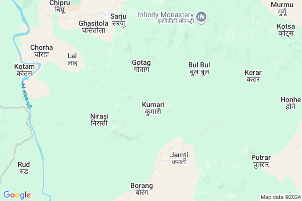
Kumari Map
EDIT Map
Add Your House
 ..
..
Current Corona Virus Infected Patients Count in Gumla District
| City Name | District Name | Total Covid cases |
|---|
Locality Name :
Kumari
( कुमारी )
Block Name : Bishunpur
District : Gumla
State : Jharkhand
Language : Nagpuri and Hindi, Oriya, Bihari, Kurukh.
Current Time 01:16 PM
Date: Sunday , Apr 27,2025 (IST)
Time zone: IST (UTC+5:30)
Elevation / Altitude: 643 meters. Above Seal level
Telephone Code / Std Code: 06523
Assembly constituency : Bishunpur assembly constituency
Assembly MLA : CHAMRA LINDA
Lok Sabha constituency : Lohardaga parliamentary constituency
Parliament MP : SUDARSHAN BHAGAT
Serpanch Name :
Main Village Name : Kumari
Commodities Prices : Lohardaga Market / Mandi
Kumari Live Weather
Temperature: 36.0 °C
overcast clouds
Humidity: 15%
Wind : 1.45 mt/sec towards SW
StationName : "NeturhÄ\u0081t"
observed on Now
Temperature: 36.0 °C
overcast clouds
Humidity: 15%
Wind : 1.45 mt/sec towards SW
StationName : "NeturhÄ\u0081t"
observed on Now
Kumari Weather Forecast for Next 5 days
28-04-2025
22.5°C to 33.3°C
overcast clouds, light rain
22.5°C to 33.3°C
overcast clouds, light rain
29-04-2025
21.2°C to 35.5°C
broken clouds, scattered clouds, light rain, overcast clouds, clear sky
21.2°C to 35.5°C
broken clouds, scattered clouds, light rain, overcast clouds, clear sky
30-04-2025
20.3°C to 37.9°C
clear sky, overcast clouds, broken clouds, few clouds
20.3°C to 37.9°C
clear sky, overcast clouds, broken clouds, few clouds
01-05-2025
20.5°C to 39.7°C
scattered clouds, clear sky, light rain, broken clouds, few clouds
20.5°C to 39.7°C
scattered clouds, clear sky, light rain, broken clouds, few clouds
02-05-2025
20.4°C to 37.8°C
clear sky, scattered clouds, few clouds, light rain, moderate rain, overcast clouds, broken clouds
20.4°C to 37.8°C
clear sky, scattered clouds, few clouds, light rain, moderate rain, overcast clouds, broken clouds
Rivers Near Kumari
South Koel River
Tati
South Koel River
Tati
About Kumari
Correct below Info and add more info about KumariKumari is a small Village/hamlet in Bishunpur Block in Gumla District of Jharkhand State, India. It comes under Kumari Panchayath. It is located 71 KM towards North from District head quarters Gumla. 26 KM from Bishunpur. 112 KM from State capital Ranchi
Kumari is surrounded by Kisko Block towards East , Latehar Block towards North , Bishunpur Block towards South , Senha Block towards South .
Lohardaga , Gumla , Daltonganj , Churi are the near by Cities to Kumari.
Kumari 2011 Census Details
Kumari Local Language is Nagpuri. Kumari Village Total population is 339 and number of houses are 70. Female Population is 50.7%. Village literacy rate is 51.9% and the Female Literacy rate is 20.6%.
Population
| Census Parameter | Census Data |
| Total Population | 339 |
| Total No of Houses | 70 |
| Female Population % | 50.7 % ( 172) |
| Total Literacy rate % | 51.9 % ( 176) |
| Female Literacy rate | 20.6 % ( 70) |
| Scheduled Tribes Population % | 97.3 % ( 330) |
| Scheduled Caste Population % | 0.0 % ( 0) |
| Working Population % | 73.5 % |
| Child(0 -6) Population by 2011 | 53 |
| Girl Child(0 -6) Population % by 2011 | 58.5 % ( 31) |
Kumari Census More Deatils.
Politics in Kumari
Bharatiya Janata Party , BJP , RAKAP , JMM , INC are the major political parties in this area.Polling Stations /Booths near Kumari
1)Upg. Middle School Heswe2)Upg. Middle School Manjira
3)Community Hall Turiyadih
4)Upg. Middle School Jhal Jamira
5)Middle School Tumse
HOW TO REACH Kumari
By Rail
There is no railway station near to Kumari in less than 10 km.Pincodes near Kumari
829207 ( Latehar Rsso ) , 829204 ( Chhipadohar ) , 835231 ( Bishunpur )Colleges near Kumari
Baij Nath Jalan College
Address :
Tana Bhagat College
Address :
Albert Ekka Collage
Address :
Schools near Kumari
Govt Health Centers near Kumari
1) HSC SARJU , HSC BUILDING , ,2) HSC BANDUA , HSC BUILDING , ,
3) PHC JORI , PHC Jori , ,
Sub Villages in Kumari
Hospitals in Kumari,Bishunpur
Govt Hospital Netarhat
Ghaghra - Netarhat Rd; Birjiatoli; Jharkhand 822119; India
21.8 KM distance Detail
more ..
Petrol Bunks in Kumari,Bishunpur
Shiv Shakti Services; ESSAR
Latehar Bypass; Sasang; Latehar; Jharkhand 829206; India
22.7 KM distance Detail
more ..
Electronic Shops in Kumari,Bishunpur
Ayushi Telecome Moble Sell And Sevice Centre
; Nawagarh; Jharkhand 829207; India
15.2 KM distance Detail
About Kumari &
History
How to reach Kumari
Tourist Places Near By Kumari
Schools in Kumari
Colleges in Kumari
Temperature & weather of Kumari
places in Kumari
Kumari photos
More Information
How to reach Kumari
Tourist Places Near By Kumari
Schools in Kumari
Colleges in Kumari
Temperature & weather of Kumari
places in Kumari
Kumari photos
More Information
Village Talk
Post News or Events about this Village
Near Cities
Lohardaga 37 KM near
Gumla 69 KM near
Daltonganj 71 KM near
Churi 73 KM near
Lohardaga 37 KM near
Gumla 69 KM near
Daltonganj 71 KM near
Churi 73 KM near
Near By Taluks
Garu 13 KM near
Kisko 22 KM near
Latehar 23 KM near
Bishunpur 25 KM near
Garu 13 KM near
Kisko 22 KM near
Latehar 23 KM near
Bishunpur 25 KM near
Near By Air Ports
Ranchi Airport 110 KM near
Gaya Airport 156 KM near
Patna Airport 261 KM near
Varanasi Airport 290 KM near
Ranchi Airport 110 KM near
Gaya Airport 156 KM near
Patna Airport 261 KM near
Varanasi Airport 290 KM near
Near By Tourist Places
Netarhat 20 KM near
Latehar 21 KM near
Lohardaga 37 KM near
Betla National Park 41 KM near
Palamu 42 KM near
Netarhat 20 KM near
Latehar 21 KM near
Lohardaga 37 KM near
Betla National Park 41 KM near
Palamu 42 KM near
Near By Districts
Latehar 21 KM near
Lohardaga 37 KM near
Palamu 67 KM near
Gumla 69 KM near
Latehar 21 KM near
Lohardaga 37 KM near
Palamu 67 KM near
Gumla 69 KM near
Near By RailWay Station
Latehar Rail Way Station 18 KM near
Tori Junction Rail Way Station 40 KM near
Latehar Rail Way Station 18 KM near
Tori Junction Rail Way Station 40 KM near