| Home | City Bus | Maps | Villages | Cities | Rail | Tourist Places | School | College | Pin Codes | Corona Cases Count |
| Distance Calculator Bus Services IFSC Codes Trace Mobile Number Weather Search Place Trace IP Available Cash ATM/Banks Locate Polling Booth Report an Error contact People |
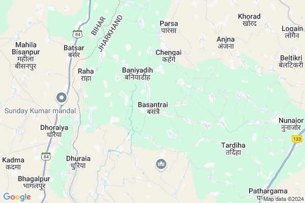
Basantpur
Basantpur Map
EDIT Map
Add Your House
 ..
..
Current Corona Virus Infected Patients Count in Godda District
| City Name | District Name | Total Covid cases |
|---|
Locality Name :
Basantpur
( बसंतपुर )
Block Name : Pathergama
District : Godda
State : Jharkhand
Language : Hindi and Santali
Current Time 08:39 AM
Date: Wednesday , Apr 30,2025 (IST)
Time zone: IST (UTC+5:30)
Elevation / Altitude: 53 meters. Above Seal level
Telephone Code / Std Code: 06437
Assembly constituency : Godda assembly constituency
Assembly MLA : Amit Kumar Mandal
Lok Sabha constituency : Godda parliamentary constituency
Parliament MP : Nishikant Dubey
Serpanch Name :
Pin Code : 814155
Post Office Name : Basantrai
Main Village Name : Basantpur
Commodities Prices : Samsi Market / Mandi
Basantpur Live Weather
Temperature: 26.2 °C
broken clouds
Humidity: 64%
Wind : 3.35 mt/sec towards E
StationName : "Godda"
observed on 59 Mins Back
Temperature: 26.2 °C
broken clouds
Humidity: 64%
Wind : 3.35 mt/sec towards E
StationName : "Godda"
observed on 59 Mins Back
Basantpur Weather Forecast for Next 5 days
01-05-2025
27.8°C to 34.8°C
broken clouds, scattered clouds, few clouds, clear sky
27.8°C to 34.8°C
broken clouds, scattered clouds, few clouds, clear sky
02-05-2025
25.9°C to 36.0°C
few clouds, clear sky, light rain, broken clouds
25.9°C to 36.0°C
few clouds, clear sky, light rain, broken clouds
03-05-2025
25.8°C to 36.6°C
broken clouds, scattered clouds, overcast clouds, clear sky, light rain
25.8°C to 36.6°C
broken clouds, scattered clouds, overcast clouds, clear sky, light rain
04-05-2025
26.0°C to 37.6°C
few clouds, clear sky, overcast clouds, light rain, scattered clouds, broken clouds
26.0°C to 37.6°C
few clouds, clear sky, overcast clouds, light rain, scattered clouds, broken clouds
05-05-2025
25.6°C to 38.2°C
scattered clouds, clear sky, few clouds, light rain
25.6°C to 38.2°C
scattered clouds, clear sky, few clouds, light rain
Rivers Near Basantpur
Chir
Chandan
Chir
Chandan
About Basantpur
Correct below Info and add more info about BasantpurBasantpur is a small Village/hamlet in Pathergama Block in Godda District of Jharkhand State, India. It comes under Basantpur Panchayath. It is located 21 KM towards North from District head quarters Godda. 6 KM from Pathergama. 310 KM from State capital Ranchi
Basantpur Pin code is 814155 and postal head office is Basantrai .
Kaithpura ( 2 KM ) , Dhapra ( 4 KM ) , Kewa ( 4 KM ) , Beldiha ( 5 KM ) , Derma ( 5 KM ) are the nearby Villages to Basantpur. Basantpur is surrounded by Dhuraiya Block towards west , Mahagama Block towards East , Sonhaula Block towards North , Rajaun Block towards west .
Godda , Colgong , Amarpur , Banka are the near by Cities to Basantpur.
This Place is in the border of the Godda District and Banka District. Banka District Dhuraiya is west towards this place . It is near to the Bihar State Border.
Demographics of Basantpur
Hindi is the Local Language here.Politics in Basantpur
Bharatiya Janata Party , BJP , INC are the major political parties in this area.Polling Stations /Booths near Basantpur
1)Primary School Badhara (urdu) Barhara2)+2 Ng High School Pathergama
3)Primary School Mariya Tola Tukka
4)Upgraded Middle School
5)Upgraded Middle School Baghakol At Kolhadda (north Side)
HOW TO REACH Basantpur
By Rail
There is no railway station near to Basantpur in less than 10 km.Colleges near Basantpur
Janajatiya Mahavidyalay Pathergama
Address :
M A K Azad College.basantroy
Address :
Schools near Basantpur
Bhartiya Vidya Niketan , Bandanwar
Address : Near SBI Bank
Shishu Giyan Kandra,mednichak
Address : At-MEDNICHAK
Post-KADMA
P.s- BASANTROY
Dist-GODDA
State-JHARKHAND
Utkarmit Meddie School Mednichak
Address : AT _MEDMICHAK
POST_KADMA
P.S_BASANTROY
DIST_GODDA
STATE_JHARKHAND
Millat High School Dhapra
Address : Dhapra.com
Govt Health Centers near Basantpur
1) HSC BASANTRAI , Basantrai , Basantrai , Basantrai2) PHC BASANTRAI , PHC BASANTRAI , BASANTRAI , BASANTRAI
3) HSC PAKARIYA , PAKARIYA , PAKARIYA , PAKARIYA
Sub Villages in Basantpur
Petrol Bunks in Basantpur,Pathergama
bharat Petroleum Shivam Bharat Petrol Pump
ghat; Pathargama; Jharkhand 814147; India
11.8 KM distance Detail
more ..
Schools in Basantpur,Pathergama
Little Angel Public School Gadalbag Basantrai
Basan Sarai Gadal; Jharkhand 814155; India
0.2 KM distance Detail
About Basantpur &
History
How to reach Basantpur
Tourist Places Near By Basantpur
Schools in Basantpur
Colleges in Basantpur
Temperature & weather of Basantpur
places in Basantpur
Basantpur photos
More Information
How to reach Basantpur
Tourist Places Near By Basantpur
Schools in Basantpur
Colleges in Basantpur
Temperature & weather of Basantpur
places in Basantpur
Basantpur photos
More Information
Village Talk
Post News or Events about this Village
Near Cities
Godda 21 KM near
Colgong 32 KM near
Amarpur 34 KM near
Banka 35 KM near
Godda 21 KM near
Colgong 32 KM near
Amarpur 34 KM near
Banka 35 KM near
Near By Taluks
Pathergama 6 KM near
Mahagama 9 KM near
Dhuraiya 10 KM near
Sonhaula 16 KM near
Pathergama 6 KM near
Mahagama 9 KM near
Dhuraiya 10 KM near
Sonhaula 16 KM near
Near By Air Ports
Bagdogra Airport 244 KM near
Patna Airport 248 KM near
Gaya Airport 256 KM near
Ranchi Airport 298 KM near
Bagdogra Airport 244 KM near
Patna Airport 248 KM near
Gaya Airport 256 KM near
Ranchi Airport 298 KM near
Near By Tourist Places
Bhagalpur 38 KM near
Sahibganj 57 KM near
Deoghar 85 KM near
Pakur 86 KM near
Dumka 91 KM near
Bhagalpur 38 KM near
Sahibganj 57 KM near
Deoghar 85 KM near
Pakur 86 KM near
Dumka 91 KM near
Near By Districts
Godda 21 KM near
Banka 35 KM near
Bhagalpur 38 KM near
Sahebganj 57 KM near
Godda 21 KM near
Banka 35 KM near
Bhagalpur 38 KM near
Sahebganj 57 KM near
Near By RailWay Station
Ghoga Rail Way Station 26 KM near
Ekchari Rail Way Station 28 KM near
Ghoga Rail Way Station 26 KM near
Ekchari Rail Way Station 28 KM near