| Home | City Bus | Maps | Villages | Cities | Rail | Tourist Places | School | College | Pin Codes | Corona Cases Count |
| Distance Calculator Bus Services IFSC Codes Trace Mobile Number Weather Search Place Trace IP Available Cash ATM/Banks Locate Polling Booth Report an Error contact People |
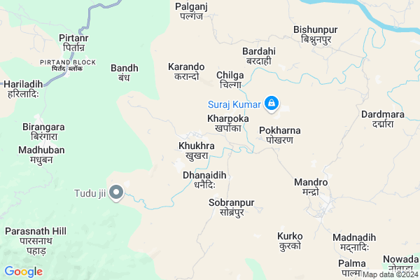
Jitpur Map
EDIT Map
Add Your House
 ..
..
Current Corona Virus Infected Patients Count in Giridih District
| City Name | District Name | Total Covid cases |
|---|---|---|
| Giridih District | Giridih | 1 |
Locality Name :
Jitpur
( जीतपुर )
Block Name : Pirtand
District : Giridih
State : Jharkhand
Language : Hindi and Santali
Current Time 08:28 PM
Date: Wednesday , Feb 05,2025 (IST)
Time zone: IST (UTC+5:30)
Elevation / Altitude: 332 meters. Above Seal level
Telephone Code / Std Code: 06532
Assembly constituency : Giridih assembly constituency
Assembly MLA :
Lok Sabha constituency : Giridih parliamentary constituency
Parliament MP :
Serpanch Name :
Main Village Name : Jitpur
Commodities Prices : Purulia Market / Mandi
Jitpur Live Weather
Temperature: 24.4 °C
clear sky
Humidity: 34%
Wind : 3.29 mt/sec towards N
StationName : "TopchÄ\u0081nchi"
observed on 44 Mins Back
Temperature: 24.4 °C
clear sky
Humidity: 34%
Wind : 3.29 mt/sec towards N
StationName : "TopchÄ\u0081nchi"
observed on 44 Mins Back
Jitpur Weather Forecast for Next 5 days
06-02-2025
20.5°C to 23.7°C
clear sky
20.5°C to 23.7°C
clear sky
07-02-2025
16.0°C to 30.8°C
clear sky
16.0°C to 30.8°C
clear sky
08-02-2025
14.3°C to 28.7°C
clear sky
14.3°C to 28.7°C
clear sky
09-02-2025
13.9°C to 28.7°C
clear sky, few clouds
13.9°C to 28.7°C
clear sky, few clouds
10-02-2025
15.1°C to 30.2°C
clear sky
15.1°C to 30.2°C
clear sky
National Highways Reachable To Jitpur
Nationa High Way :NH218
Nationa High Way :NH218
Rivers Near Jitpur
Puthro
Barakar River
Puthro
Barakar River
About Jitpur
Correct below Info and add more info about JitpurJitpur is a small Village/hamlet in Pirtand Block in Giridih District of Jharkhand State, India. It comes under Jitpur Panchayath. It is located 24 KM towards South from District head quarters Giridih. 140 KM from State capital Ranchi
Jitpur is surrounded by Topchanchi Block towards South , Dumri Block towards west , Giridih Block towards North , Tundi Block towards East .
Gomoh , Giridih , Chandrapura , Dhanbad are the near by Cities to Jitpur.
This Place is in the border of the Giridih District and Dhanbad District. Dhanbad District Topchanchi is South towards this place .
Jitpur 2011 Census Details
Jitpur Local Language is Hindi. Jitpur Village Total population is 198 and number of houses are 37. Female Population is 50.5%. Village literacy rate is 18.2% and the Female Literacy rate is 7.1%.
Population
| Census Parameter | Census Data |
| Total Population | 198 |
| Total No of Houses | 37 |
| Female Population % | 50.5 % ( 100) |
| Total Literacy rate % | 18.2 % ( 36) |
| Female Literacy rate | 7.1 % ( 14) |
| Scheduled Tribes Population % | 100.0 % ( 198) |
| Scheduled Caste Population % | 0.0 % ( 0) |
| Working Population % | 48.5 % |
| Child(0 -6) Population by 2011 | 60 |
| Girl Child(0 -6) Population % by 2011 | 46.7 % ( 28) |
Jitpur Census More Deatils.
Politics in Jitpur
AJSU Party , JVM , BJP , JMM , are the major political parties in this area.Polling Stations /Booths near Jitpur
1)Ums Chunglo2)U.m.s Chilga
3)Samudayak Bhawan Mosafdih
4)Ps Dhariyadih Bhuiyantoli
5)U.m.s Garhatand
HOW TO REACH Jitpur
By Rail
There is no railway station near to Jitpur in less than 10 km.Pincodes near Jitpur
825108 ( Pirtand ) , 825329 ( Shikherjee ) , 828402 ( Topchanchi )Colleges near Jitpur
Parasnath Inter College , Isri Bazaar
Address :
Ramnam College Ghoranji
Address :
Sariya College Suriya
Address :
Rupeshwoods College
Address :
Govt Polytechnic Ranchi
Address :
Schools near Jitpur
Middle School, Palganj
Address : Palganj, giridih
Govt Health Centers near Jitpur
1) HSC SOBARNPUR , 3 , SOBRANPUR , BARIYARPUR SE RAGHT2) HSC MAHESHLITI , 10 , MAHESHALITY , RAJESH KUMAR HOME KE BAGAL ME
3) HSC MADHUBAN , MAIN ROAD MADHUBAN , MADHUBAN , MADHUBAN THANA KE SAMANE
Sub Villages in Jitpur
Petrol Bunks in Jitpur,Pirtand
OM SHIVSHAKTI FUEL CENTRE
CHIRKI (SH14) ; DISTT.:GIR; GIRIDIH; Jharkhand 825108; India
9.4 KM distance Detail
SACH KHAND AUTO FUELS
23.934626; 86.105550; Grand Trunk Rd; Hithwar; Jharkhand 825167; India
17.7 KM distance Detail
more ..
Colleges in Jitpur,Pirtand
City Institute of Management & Technology (CIMT)
Main Road Koldiha (Rahmat Nagar); Giridih; Jharkhand 815301; India
22.8 KM distance Detail
more ..
Electronic Shops in Jitpur,Pirtand
Javed Telecom
Pandey Path; Burma Mines Market; Adityapur; Jamshedpur; Jharkhand 831013; India
9.4 KM distance Detail
Local Parks in Jitpur,Pirtand
Swami Vivekananad Park
Baniyadih; Paparwatand Colony; Giridih; Jharkhand 815311; India
21.7 KM distance Detail
Governement Offices near Jitpur,Pirtand
About Jitpur &
History
How to reach Jitpur
Tourist Places Near By Jitpur
Schools in Jitpur
Colleges in Jitpur
Temperature & weather of Jitpur
places in Jitpur
Jitpur photos
More Information
How to reach Jitpur
Tourist Places Near By Jitpur
Schools in Jitpur
Colleges in Jitpur
Temperature & weather of Jitpur
places in Jitpur
Jitpur photos
More Information
Village Talk
Post News or Events about this Village
Near Cities
Gomoh 18 KM near
Giridih 23 KM near
Chandrapura 34 KM near
Dhanbad 35 KM near
Gomoh 18 KM near
Giridih 23 KM near
Chandrapura 34 KM near
Dhanbad 35 KM near
Near By Taluks
Pirtand 0 KM near
Topchanchi 15 KM near
Dumri 19 KM near
Giridih 22 KM near
Pirtand 0 KM near
Topchanchi 15 KM near
Dumri 19 KM near
Giridih 22 KM near
Near By Air Ports
Ranchi Airport 134 KM near
Gaya Airport 172 KM near
Patna Airport 235 KM near
Netaji Subhas Chandra Bose Airport 304 KM near
Ranchi Airport 134 KM near
Gaya Airport 172 KM near
Patna Airport 235 KM near
Netaji Subhas Chandra Bose Airport 304 KM near
Near By Tourist Places
Giridh 22 KM near
Dhanbad 35 KM near
Hazaribagh 42 KM near
Bokaro Steel City 47 KM near
Jamtara 68 KM near
Giridh 22 KM near
Dhanbad 35 KM near
Hazaribagh 42 KM near
Bokaro Steel City 47 KM near
Jamtara 68 KM near
Near By Districts
Giridih 23 KM near
Dhanbad 35 KM near
Bokaro 40 KM near
Jamtara 65 KM near
Giridih 23 KM near
Dhanbad 35 KM near
Bokaro 40 KM near
Jamtara 65 KM near
Near By RailWay Station
Netaji Sc Bose Junction Gomoh Rail Way Station 19 KM near
Parasnath Rail Way Station 22 KM near
Netaji Sc Bose Junction Gomoh Rail Way Station 19 KM near
Parasnath Rail Way Station 22 KM near