| Home | City Bus | Maps | Villages | Cities | Rail | Tourist Places | School | College | Pin Codes | Corona Cases Count |
| Distance Calculator Bus Services IFSC Codes Trace Mobile Number Weather Search Place Trace IP Available Cash ATM/Banks Locate Polling Booth Report an Error contact People |
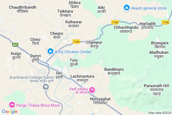
Barganda Map
EDIT Map
Add Your House
 ..
..
Current Corona Virus Infected Patients Count in Giridih District
| City Name | District Name | Total Covid cases |
|---|---|---|
| Giridih District | Giridih | 1 |
Locality Name :
Barganda
( बरगंडा )
Block Name : Dumri
District : Giridih
State : Jharkhand
Language : Hindi and Santali
Current Time 08:53 AM
Date: Wednesday , Apr 30,2025 (IST)
Time zone: IST (UTC+5:30)
Elevation / Altitude: 332 meters. Above Seal level
Telephone Code / Std Code: 06558
Assembly constituency : Dumri assembly constituency
Assembly MLA :
Lok Sabha constituency : Giridih parliamentary constituency
Parliament MP :
Serpanch Name :
Main Village Name : Barganda
Commodities Prices : Purulia Market / Mandi
Barganda Live Weather
Temperature: 26.8 °C
broken clouds
Humidity: 49%
Wind : 2.61 mt/sec towards E
StationName : "TopchÄ\u0081nchi"
observed on 30 Mins Back
Temperature: 26.8 °C
broken clouds
Humidity: 49%
Wind : 2.61 mt/sec towards E
StationName : "TopchÄ\u0081nchi"
observed on 30 Mins Back
Barganda Weather Forecast for Next 5 days
01-05-2025
26.8°C to 34.4°C
broken clouds, scattered clouds, clear sky
26.8°C to 34.4°C
broken clouds, scattered clouds, clear sky
02-05-2025
25.6°C to 36.1°C
scattered clouds, clear sky, light rain, overcast clouds
25.6°C to 36.1°C
scattered clouds, clear sky, light rain, overcast clouds
03-05-2025
24.6°C to 35.9°C
broken clouds, clear sky, few clouds, scattered clouds
24.6°C to 35.9°C
broken clouds, clear sky, few clouds, scattered clouds
04-05-2025
25.1°C to 36.6°C
scattered clouds, light rain, few clouds, clear sky
25.1°C to 36.6°C
scattered clouds, light rain, few clouds, clear sky
05-05-2025
25.0°C to 36.7°C
clear sky, moderate rain, scattered clouds, light rain
25.0°C to 36.7°C
clear sky, moderate rain, scattered clouds, light rain
National Highways Reachable To Barganda
Nationa High Way :NH218
Nationa High Way :NH18
Nationa High Way :NH218
Nationa High Way :NH18
Rivers Near Barganda
Barakar River
Damodar
Barakar River
Damodar
About Barganda
Correct below Info and add more info about BargandaBarganda is a small Village/hamlet in Dumri Block in Giridih District of Jharkhand State, India. It comes under Barganda Panchayath. It is located 37 KM towards west from District head quarters Giridih. 123 KM from State capital Ranchi
Barganda is surrounded by Nawadih Block towards South , Pirtand Block towards East , Topchanchi Block towards East , Bagodar Block towards west .
Gomoh , Phusro , Chandrapura , Giridih are the near by Cities to Barganda.
Demographics of Barganda
Hindi is the Local Language here.Politics in Barganda
AJSU Party , JD(U) , BJP , JMM are the major political parties in this area.Polling Stations /Booths near Barganda
1)M.s. Birni Old Bhawan2)M.s. Telo W.p.
3)M.s. Chainpur West Bhag
4)M.s. Chegdo East Bhag
5)P.s.teliyakunda
HOW TO REACH Barganda
By Rail
Parasnath Rail Way Station , Chegro Rail Way Station are the very nearby railway stations to Barganda.Pincodes near Barganda
825167 ( Isri Bazar ) , 825106 ( Dumri ) , 825108 ( Pirtand )Colleges near Barganda
Parasnath Inter College , Isri Bazaar
Address :
Jharkhand Commerce Collage
Address :
Schools near Barganda
Gyan Bharti
Address : vpo nagri, ps nimiaghat, block dumri, distt giridih, jharkhand,
Emperial Kids School
Address : vpo nagri, ps nimiaghat, block dumri, distt giridih, jharkhand.
D.a.v. Central School
Address : PROF. COLONY,
G.T. ROAD,
ISRI BAZAR
Mojilal Sahu High School
Address : vpo nagri, ps nimiaghat, distt giridih, jharkhand,
Govt Health Centers near Barganda
1) Bhandaro phc , bhandaro , bhandaro , near school m.v bhandaro school2) HSC BHANDARO , , ,
3) Roshnatunda , roshnatunda , roshnatunda , near railway phatak
Sub Villages in Barganda
Hospitals in Barganda,Dumri
gurucharan medical and paras ausdhalay
Isri Bazar; Dumri; Jharkhand 825167; India
3.4 KM distance Detail
more ..
Petrol Bunks in Barganda,Dumri
HP PETROL PUMP - SRI PARASNATH AUTOMOBILES
Isribasar GT Road Dist Giridih Jharkhand; Ranchi; Jharkhand 825107; India
3.8 KM distance Detail
HP PETROL PUMP - KANAKLAL AND COMPANY DUMRI
PO Dumri Dist State Jharkhand; Bagador; Jharkhand 825108; India
5.4 KM distance Detail
more ..
Colleges in Barganda,Dumri
Parasnath Inter College Isri Bazar
Isri Bazar; Dumri; Jharkhand 825167; India
3.7 KM distance Detail
more ..
Schools in Barganda,Dumri
Yadunath Girl High School Okani Hazaribag
Hazaribagh; Jharkhand 825167; India
1.6 KM distance Detail
Electronic Shops in Barganda,Dumri
J Mahto Tellecom
hatiyatand giridih road; chainpur; Giridih; Jharkhand; India
2.4 KM distance Detail
About Barganda &
History
How to reach Barganda
Tourist Places Near By Barganda
Schools in Barganda
Colleges in Barganda
Temperature & weather of Barganda
places in Barganda
Barganda photos
More Information
How to reach Barganda
Tourist Places Near By Barganda
Schools in Barganda
Colleges in Barganda
Temperature & weather of Barganda
places in Barganda
Barganda photos
More Information
Village Talk
Post News or Events about this Village
Near Cities
Gomoh 20 KM near
Phusro 29 KM near
Chandrapura 31 KM near
Giridih 35 KM near
Gomoh 20 KM near
Phusro 29 KM near
Chandrapura 31 KM near
Giridih 35 KM near
Near By Taluks
Dumri 0 KM near
Nawadih 19 KM near
Pirtand 19 KM near
Topchanchi 24 KM near
Dumri 0 KM near
Nawadih 19 KM near
Pirtand 19 KM near
Topchanchi 24 KM near
Near By Air Ports
Ranchi Airport 119 KM near
Gaya Airport 156 KM near
Patna Airport 226 KM near
Netaji Subhas Chandra Bose Airport 320 KM near
Ranchi Airport 119 KM near
Gaya Airport 156 KM near
Patna Airport 226 KM near
Netaji Subhas Chandra Bose Airport 320 KM near
Near By Tourist Places
Hazaribagh 27 KM near
Giridh 35 KM near
Bokaro Steel City 43 KM near
Dhanbad 49 KM near
Jhumri telaiya 79 KM near
Hazaribagh 27 KM near
Giridh 35 KM near
Bokaro Steel City 43 KM near
Dhanbad 49 KM near
Jhumri telaiya 79 KM near
Near By Districts
Giridih 35 KM near
Bokaro 40 KM near
Dhanbad 49 KM near
Hazaribagh 78 KM near
Giridih 35 KM near
Bokaro 40 KM near
Dhanbad 49 KM near
Hazaribagh 78 KM near
Near By RailWay Station
Parasnath Rail Way Station 3.1 KM near
Chegro Rail Way Station 5.2 KM near
Nimiaghat Rail Way Station 9.1 KM near
Netaji Sc Bose Junction Gomoh Rail Way Station 18 KM near
Parasnath Rail Way Station 3.1 KM near
Chegro Rail Way Station 5.2 KM near
Nimiaghat Rail Way Station 9.1 KM near
Netaji Sc Bose Junction Gomoh Rail Way Station 18 KM near