| Home | City Bus | Maps | Villages | Cities | Rail | Tourist Places | School | College | Pin Codes | Corona Cases Count |
| Distance Calculator Bus Services IFSC Codes Trace Mobile Number Weather Search Place Trace IP Available Cash ATM/Banks Locate Polling Booth Report an Error contact People |
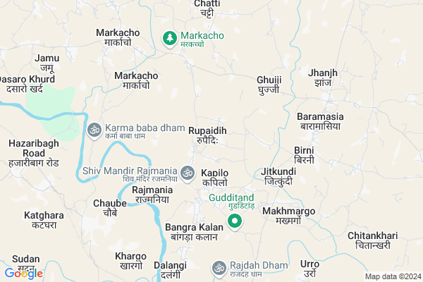
Rupaidih Map
EDIT Map
Add Your House
 ..
..
Current Corona Virus Infected Patients Count in Giridih District
| City Name | District Name | Total Covid cases |
|---|---|---|
| Giridih District | Giridih | 1 |
Locality Name :
Rupaidih
( रुपईडीह )
Block Name : Birni
District : Giridih
State : Jharkhand
Language : Hindi and Santali
Current Time 09:13 AM
Date: Wednesday , Apr 30,2025 (IST)
Time zone: IST (UTC+5:30)
Elevation / Altitude: 607 meters. Above Seal level
Telephone Code / Std Code: 06554
Assembly constituency : Bagodar assembly constituency
Assembly MLA : VINOD KUMAR SINGH
Lok Sabha constituency : Kodarma parliamentary constituency
Parliament MP : ANNPURNA DEVI
Serpanch Name :
Pin Code : 815302
Post Office Name : Giridih Town
Main Village Name : Rupaidih
Rupaidih Live Weather
Temperature: 26.0 °C
scattered clouds
Humidity: 52%
Wind : 3.33 mt/sec towards E
StationName : "Barki Saria"
observed on 1 Hours Back
Temperature: 26.0 °C
scattered clouds
Humidity: 52%
Wind : 3.33 mt/sec towards E
StationName : "Barki Saria"
observed on 1 Hours Back
Rupaidih Weather Forecast for Next 5 days
01-05-2025
26.2°C to 35.4°C
broken clouds, scattered clouds, clear sky, light rain
26.2°C to 35.4°C
broken clouds, scattered clouds, clear sky, light rain
02-05-2025
25.2°C to 35.3°C
clear sky, few clouds, broken clouds, light rain, overcast clouds, scattered clouds
25.2°C to 35.3°C
clear sky, few clouds, broken clouds, light rain, overcast clouds, scattered clouds
03-05-2025
24.0°C to 36.6°C
few clouds, clear sky, broken clouds
24.0°C to 36.6°C
few clouds, clear sky, broken clouds
04-05-2025
25.3°C to 37.3°C
scattered clouds, clear sky, broken clouds
25.3°C to 37.3°C
scattered clouds, clear sky, broken clouds
05-05-2025
25.3°C to 37.5°C
clear sky, few clouds, light rain, broken clouds, scattered clouds
25.3°C to 37.5°C
clear sky, few clouds, light rain, broken clouds, scattered clouds
Rivers Near Rupaidih
Puthro
Barakar River
Puthro
Barakar River
About Rupaidih
Correct below Info and add more info about RupaidihRupaidih is a small Village/hamlet in Birni Block in Giridih District of Jharkhand State, India. It comes under Rupaidih Panchayath. It is located 50 KM towards west from District head quarters Giridih. 13 KM from Birni. 139 KM from State capital Ranchi
Rupaidih Pin code is 815302 and postal head office is Giridih Town .
Bangra Kala ( 5 KM ) , Birni ( 5 KM ) , Simra Dhab ( 6 KM ) , Makhmargo ( 6 KM ) , Chatti ( 7 KM ) are the nearby Villages to Rupaidih. Rupaidih is surrounded by Markacho Block towards North , Dhanwar Block towards North , Bagodar Block towards South , Jainagar Block towards west .
Jhumri Tilaiya , Giridih , Gumia , Gomoh are the near by Cities to Rupaidih.
This Place is in the border of the Giridih District and Koderma District. Koderma District Markacho is North towards this place .
Rupaidih 2011 Census Details
Rupaidih Local Language is Hindi. Rupaidih Village Total population is 1823 and number of houses are 302. Female Population is 51.0%. Village literacy rate is 54.6% and the Female Literacy rate is 20.6%.
Population
| Census Parameter | Census Data |
| Total Population | 1823 |
| Total No of Houses | 302 |
| Female Population % | 51.0 % ( 929) |
| Total Literacy rate % | 54.6 % ( 995) |
| Female Literacy rate | 20.6 % ( 376) |
| Scheduled Tribes Population % | 0.0 % ( 0) |
| Scheduled Caste Population % | 27.3 % ( 498) |
| Working Population % | 43.6 % |
| Child(0 -6) Population by 2011 | 353 |
| Girl Child(0 -6) Population % by 2011 | 46.7 % ( 165) |
Rupaidih Census More Deatils.
Politics in Rupaidih
JVM , Bharatiya Janata Party , CPI(M) , CPI(ML)(L) , BJP , CPI(M)(L) are the major political parties in this area.Polling Stations /Booths near Rupaidih
1)U.m.s. Brinda2)U.m.s. Dalangi East Part
3)U.m.s. Sariya Khurd West Part
4)M.s. Jarmune
5)M.s. Kapilo West Part
HOW TO REACH Rupaidih
By Rail
Chaube Rail Way Station , Dasara Rail Way Station are the very nearby railway stations to Rupaidih.Colleges near Rupaidih
B.d. Inter College
Address :
Schools near Rupaidih
Saraswati Shishu Mandir,bharkatta
Address : baidapahri,near high school bharkatta.
Utkramit Middle School,keshodih
Address : keshodih,825324
Govt Health Centers near Rupaidih
1) HSC AMBADIH , HSC AMBADIH , Ambadih , Near High School2) HSC BANGRAKALA , hsc bangrakala , bangrakala , near awc
3) CHC BIRNI , chc birni , birni , birni block
Sub Villages in Rupaidih
Colleges in Rupaidih,Birni
Keshonarayan collage Nimatand
Rajdhanwar Rd; Nimatand; Jharkhand 815302; India
9.4 KM distance Detail
more ..
Super Markets in Rupaidih,Birni
Chandan Genral Store
barmasiya Chowk main road raj dhanwar 825324; Birni; Jharkhand; India
5.4 KM distance Detail
Police Stations near Rupaidih,Birni
Markacho Police Station
Markacho - Baryardih Rd; Bichariya; Dardahi; Jharkhand 825318; India
9.6 KM distance Detail
Governement Offices near Rupaidih,Birni
National Human Rights Community of India
Tunmalki; Jharkhand 825412India; India
13.7 KM distance Detail
About Rupaidih &
History
How to reach Rupaidih
Tourist Places Near By Rupaidih
Schools in Rupaidih
Colleges in Rupaidih
Temperature & weather of Rupaidih
places in Rupaidih
Rupaidih photos
More Information
How to reach Rupaidih
Tourist Places Near By Rupaidih
Schools in Rupaidih
Colleges in Rupaidih
Temperature & weather of Rupaidih
places in Rupaidih
Rupaidih photos
More Information
Village Talk
Post News or Events about this Village
Near Cities
Jhumri Tilaiya 44 KM near
Giridih 48 KM near
Gumia 60 KM near
Gomoh 60 KM near
Jhumri Tilaiya 44 KM near
Giridih 48 KM near
Gumia 60 KM near
Gomoh 60 KM near
Near By Taluks
Birni 12 KM near
Markacho 16 KM near
Dhanwar 16 KM near
Bagodar 19 KM near
Birni 12 KM near
Markacho 16 KM near
Dhanwar 16 KM near
Bagodar 19 KM near
Near By Air Ports
Gaya Airport 120 KM near
Ranchi Airport 135 KM near
Patna Airport 186 KM near
Netaji Subhas Chandra Bose Airport 356 KM near
Gaya Airport 120 KM near
Ranchi Airport 135 KM near
Patna Airport 186 KM near
Netaji Subhas Chandra Bose Airport 356 KM near
Near By Tourist Places
Hazaribagh 15 KM near
Jhumri telaiya 43 KM near
Koderma 44 KM near
Giridh 49 KM near
Bokaro Steel City 82 KM near
Hazaribagh 15 KM near
Jhumri telaiya 43 KM near
Koderma 44 KM near
Giridh 49 KM near
Bokaro Steel City 82 KM near
Near By Districts
Koderma 40 KM near
Giridih 48 KM near
Hazaribagh 68 KM near
Bokaro 80 KM near
Koderma 40 KM near
Giridih 48 KM near
Hazaribagh 68 KM near
Bokaro 80 KM near
Near By RailWay Station
Hazaribagh Road Rail Way Station 13 KM near
Parsabad Rail Way Station 16 KM near
Hazaribagh Road Rail Way Station 13 KM near
Parsabad Rail Way Station 16 KM near