| Home | City Bus | Maps | Villages | Cities | Rail | Tourist Places | School | College | Pin Codes | Corona Cases Count |
| Distance Calculator Bus Services IFSC Codes Trace Mobile Number Weather Search Place Trace IP Available Cash ATM/Banks Locate Polling Booth Report an Error contact People |
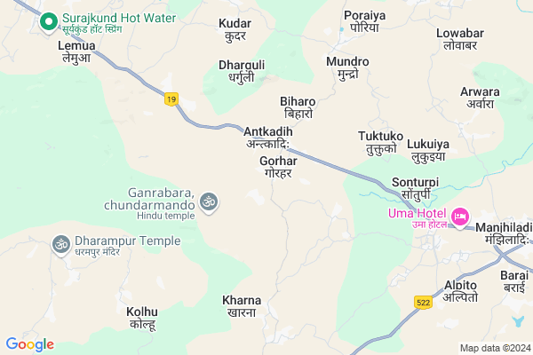
Atkadih Map
EDIT Map
Add Your House
 ..
..
Current Corona Virus Infected Patients Count in Giridih District
| City Name | District Name | Total Covid cases |
|---|---|---|
| Giridih District | Giridih | 1 |
Locality Name :
Atkadih
( अटकादिः )
Block Name : Bagodar
District : Giridih
State : Jharkhand
Language : Hindi and Santali
Current Time 12:47 PM
Date: Tuesday , Apr 29,2025 (IST)
Time zone: IST (UTC+5:30)
Elevation / Altitude: 308 meters. Above Seal level
Telephone Code / Std Code: 06557
Assembly constituency : Bagodar assembly constituency
Assembly MLA : VINOD KUMAR SINGH
Lok Sabha constituency : Kodarma parliamentary constituency
Parliament MP : ANNPURNA DEVI
Serpanch Name :
Pin Code : 825320
Post Office Name : Suriya
Main Village Name : Atkadih
Rivers Near Atkadih
Barakar River
Jaiati
Barakar River
Jaiati
About Atkadih
Correct below Info and add more info about AtkadihAtkadih is a small Village/hamlet in Bagodar Block in Giridih District of Jharkhand State, India. It comes under Atkadih Panchayath. It is located 67 KM towards west from District head quarters Giridih. 18 KM from Bagodar. 110 KM from State capital Ranchi
Atkadih Pin code is 825320 and postal head office is Suriya .
Kudar ( 6 KM ) , Jarmune (w) ( 9 KM ) , Jarmune (e) ( 9 KM ) , Parsiya ( 11 KM ) , Bagodar ( 12 KM ) are the nearby Villages to Atkadih. Atkadih is surrounded by Barkatha Block towards North , Bagodar Block towards East , Ichak Block towards west , Jainagar Block towards North .
Gumia , Tenu Dam-cum- Kathhara , Hazaribag , Jhumri Tilaiya are the near by Cities to Atkadih.
This Place is in the border of the Giridih District and Hazaribagh District. Hazaribagh District Bishnugarh is South towards this place .
Demographics of Atkadih
Hindi is the Local Language here.Politics in Atkadih
JVM , Bharatiya Janata Party , CPI(M) , CPI(ML)(L) , BJP , CPI(M)(L) are the major political parties in this area.Polling Stations /Booths near Atkadih
1)U.p.s Belatand2)P.s Madmo Middle Part Thana Vishnugarh
3)U.p.s Teliyasingha
4)U.m.s. Barmasiya
5)M.s. Pokhariya South Part
HOW TO REACH Atkadih
By Rail
There is no railway station near to Atkadih in less than 10 km.Colleges near Atkadih
Sariya College Suriya
Address :
Govt Polytechnic Ranchi
Address :
Schools near Atkadih
Little Angels Public School Kusmarja
Address : At.kusmarja po.bandkharo.
Little Angels Public School Kusmarja
Address : At.kusmarja po.bandkharo.
D A V Suriya
Address :
Middle School Govindpur
Address : NEW JHARKHAND RANCHI
Govt Health Centers near Atkadih
1) HSC GORHAR , Hsc Gorhar , Gorhar , Near govt school2) HSC ALAGDIHA , Hsc-alagdiha , , mandir
3) HSC MUNDRO , samudaik bhwan , mundro , near road
Sub Villages in Atkadih
Petrol Bunks in Atkadih,Bagodar
Sri Sai Auto Station (HPCL)petrol Pump Atkadih
Antkadih; Jharkhand 825320; India
2.1 KM distance Detail
ZAMZAM SERVICE STATION
ATKADIH; NH2; DIST- GIRIDI; GIRIDIH; Jharkhand 825322; India
3.1 KM distance Detail
more ..
Colleges in Atkadih,Bagodar
Binod Bihari Mahto Inter Mahila College Madaidih
Grand Trunk Rd; Madaidih; Jharkhand 828104; India
4.0 KM distance Detail
Gouri Devi Teachers Training College
G.T Road P.O : Rajbandh P.S : Kanksa; Burdwan; West Bengal 713212; India
8.3 KM distance Detail
Ram Krishna Vivekanand College of Education
Suriya Road; Bagodar; Jharkhand 825322; India
13.6 KM distance Detail
more ..
Schools in Atkadih,Bagodar
St.Michael Public School Atka
Lalabandh ps-Dist-; Atka; Bagodar; Jharkhand; India
1.2 KM distance Detail
Governement Offices near Atkadih,Bagodar
Ghanshyam Mandal ;TRANSPORT ENTERPRISES Home
Atkadih; Antkadih; Jharkhand 825320; India
1.7 KM distance Detail
About Atkadih &
History
How to reach Atkadih
Tourist Places Near By Atkadih
Schools in Atkadih
Colleges in Atkadih
Temperature & weather of Atkadih
places in Atkadih
Atkadih photos
More Information
How to reach Atkadih
Tourist Places Near By Atkadih
Schools in Atkadih
Colleges in Atkadih
Temperature & weather of Atkadih
places in Atkadih
Atkadih photos
More Information
Village Talk
Post News or Events about this Village
Near Cities
Gumia 39 KM near
Tenu Dam-cum- Kathhara 45 KM near
Hazaribag 45 KM near
Jhumri Tilaiya 47 KM near
Gumia 39 KM near
Tenu Dam-cum- Kathhara 45 KM near
Hazaribag 45 KM near
Jhumri Tilaiya 47 KM near
Near By Taluks
Bishnugarh 9 KM near
Barkatha 17 KM near
Bagodar 18 KM near
Ichak 29 KM near
Bishnugarh 9 KM near
Barkatha 17 KM near
Bagodar 18 KM near
Ichak 29 KM near
Near By Air Ports
Ranchi Airport 107 KM near
Gaya Airport 119 KM near
Patna Airport 199 KM near
Netaji Subhas Chandra Bose Airport 358 KM near
Ranchi Airport 107 KM near
Gaya Airport 119 KM near
Patna Airport 199 KM near
Netaji Subhas Chandra Bose Airport 358 KM near
Near By Tourist Places
Hazaribagh 19 KM near
Jhumri telaiya 46 KM near
Koderma 47 KM near
Giridh 65 KM near
Bokaro Steel City 69 KM near
Hazaribagh 19 KM near
Jhumri telaiya 46 KM near
Koderma 47 KM near
Giridh 65 KM near
Bokaro Steel City 69 KM near
Near By Districts
Hazaribagh 43 KM near
Koderma 48 KM near
Ramgarh 64 KM near
Giridih 65 KM near
Hazaribagh 43 KM near
Koderma 48 KM near
Ramgarh 64 KM near
Giridih 65 KM near
Near By RailWay Station
Hazaribagh Road Rail Way Station 20 KM near
Parsabad Rail Way Station 25 KM near
Hazaribagh Road Rail Way Station 20 KM near
Parsabad Rail Way Station 25 KM near