| Home | City Bus | Maps | Villages | Cities | Rail | Tourist Places | School | College | Pin Codes | Corona Cases Count |
| Distance Calculator Bus Services IFSC Codes Trace Mobile Number Weather Search Place Trace IP Available Cash ATM/Banks Locate Polling Booth Report an Error contact People |
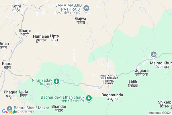
Harhad Map
EDIT Map
Add Your House
 ..
..
Current Corona Virus Infected Patients Count in Chatra District
| City Name | District Name | Total Covid cases |
|---|
Locality Name :
Harhad
( हरहद )
Block Name : Pratappur
District : Chatra
State : Jharkhand
Language : Magahi and Nagpuri,khortha,hindi And Urdu
Current Time 02:51 AM
Date: Friday , Mar 14,2025 (IST)
Time zone: IST (UTC+5:30)
Elevation / Altitude: 216 meters. Above Seal level
Telephone Code / Std Code: 06550
Assembly constituency : Chatra assembly constituency
Assembly MLA : SATYANAND BHOKTA
Lok Sabha constituency : Chatra parliamentary constituency
Parliament MP : SUNIL KUMAR SINGH
Serpanch Name :
Main Village Name : Harhad
Commodities Prices : Gadhwah Market / Mandi
Harhad Live Weather
Temperature: 22.7 °C
clear sky
Humidity: 28%
Wind : 2.16 mt/sec towards SW
StationName : "ChatrÄ\u0081"
observed on 2 Hours Back
Temperature: 22.7 °C
clear sky
Humidity: 28%
Wind : 2.16 mt/sec towards SW
StationName : "ChatrÄ\u0081"
observed on 2 Hours Back
Harhad Weather Forecast for Next 5 days
14-03-2025
21.6°C to 23.0°C
clear sky
21.6°C to 23.0°C
clear sky
15-03-2025
20.4°C to 39.1°C
clear sky
20.4°C to 39.1°C
clear sky
16-03-2025
22.1°C to 40.0°C
clear sky
22.1°C to 40.0°C
clear sky
17-03-2025
22.9°C to 40.9°C
clear sky, few clouds, scattered clouds, overcast clouds, broken clouds
22.9°C to 40.9°C
clear sky, few clouds, scattered clouds, overcast clouds, broken clouds
18-03-2025
23.6°C to 39.9°C
clear sky, few clouds, scattered clouds
23.6°C to 39.9°C
clear sky, few clouds, scattered clouds
Edit below overview about Harhad
Edit below overview about Harhad
OverView of Harhad
HarhadIn harhad there are three hindu religious temple and a school.Temple-Devi Mandap, shiv mandir, and also a temple on tongri( west)School-Utkramit madhya vidyalaya Harhad.Crop-The main crop of this village are rabi and kharif crop.Rabi-(wheat and pea)Kharif-(paddy,maize).CHANDAN PASWAN(Villager and Observer)Edit below overview about Harhad
Rivers Near Harhad
Lilajan :Niranjana
Batane
Lilajan :Niranjana
Batane
About Harhad
Harhad is a small Village/hamlet in Pratappur Block in Chatra District of Jharkhand State, India. It comes under Harhad Panchayath. It is located 35 KM towards west from District head quarters Chatra. 151 KM from State capital Ranchi
Harhad is surrounded by Imamganj Block towards North , Kunda Block towards South , Hunterganj Block towards East , Bankey Bazar Block towards North .
Chatra , Sherghati , Aurangabad , Rafiganj are the near by Cities to Harhad.
This Place is in the border of the Chatra District and Gaya District. Gaya District Imamganj is North towards this place . It is near to the Bihar State Border.
Harhad 2011 Census Details
Harhad Local Language is Magahi. Harhad Village Total population is 931 and number of houses are 173. Female Population is 46.1%. Village literacy rate is 46.0% and the Female Literacy rate is 17.2%.
Population
| Census Parameter | Census Data |
| Total Population | 931 |
| Total No of Houses | 173 |
| Female Population % | 46.1 % ( 429) |
| Total Literacy rate % | 46.0 % ( 428) |
| Female Literacy rate | 17.2 % ( 160) |
| Scheduled Tribes Population % | 6.0 % ( 56) |
| Scheduled Caste Population % | 43.5 % ( 405) |
| Working Population % | 37.5 % |
| Child(0 -6) Population by 2011 | 174 |
| Girl Child(0 -6) Population % by 2011 | 40.8 % ( 71) |
Harhad Census More Deatils.
Politics in Harhad
Bharatiya Janata Party , BJP , RJD , JVMP , INC are the major political parties in this area.Polling Stations /Booths near Harhad
1)U.m.s Sikidag2)U.m.s. Pali
3)Buniyadi School Dantar
4)U.m.s Kewliya (north)
5)U.m.s. Dholiya
HOW TO REACH Harhad
By Rail
There is no railway station near to Harhad in less than 10 km.Pincodes near Harhad
825404 ( Pratappur (Chatra) ) , 825403 ( Jori ) , 822113 ( Chhatarpur )Colleges near Harhad
Bhadrarkali Enter Collage Itkhori
Address :
No Colleage In This Villeage
Address :
Vananchal College
Address :
Schools near Harhad
British Academy Barwadih Bazar
Address : BARURA
Global Public School
Address : PRATAPPUR,CHATRA ,JHARKHAND
Global Public School
Address : PRATAPPUR,CHATRA ,JHARKHAND
Js Memorial Academy
Address : Gajwa Bagicha
Govt Health Centers near Harhad
1) HSC NANAIKALA , , Naniakala ,2) HSC GURIA , , Guria ,
3) CHC PRATAP PUR , , Pratappur ,
Sub Villages in Harhad
Hospitals in Harhad,Pratappur
Pasu Chikistasak Kendra
824206; Juran Chhapra Main Rd; Kanhauli; Sherpur urf Narayanpur Anant; Bihar 843147; India
19.9 KM distance Detail
more ..
Schools in Harhad,Pratappur
उत्क्रमित प्राथमिक विद्यालय भैंसगड़ी गोमें
villege Gome; Pratappur; Jharkhand 825404; India
2.5 KM distance Detail
Electronic Shops in Harhad,Pratappur
Raju Auto Sarvice Center
Manatu Imamganj Main Rd; Ghorighat; Jharkhand 825404; India
10.9 KM distance Detail
Digital Seva Kendra (Nasib Rahmani)
Manatu main Road; sildaha Bazar; Imamganj; Bihar 825404; India
10.9 KM distance Detail
Asia Telecom Ghorighat
Manatu Imamganj Main Rd; Ghorighat; Jharkhand 825404; India
10.9 KM distance Detail
Super Markets in Harhad,Pratappur
Sildaha Bazar Ms Online Hub
ms online hub sildaha bazar; Ghorighat; Jharkhand; India
10.9 KM distance Detail
About Harhad &
History
How to reach Harhad
Tourist Places Near By Harhad
Schools in Harhad
Colleges in Harhad
Temperature & weather of Harhad
places in Harhad
Harhad photos
More Information
How to reach Harhad
Tourist Places Near By Harhad
Schools in Harhad
Colleges in Harhad
Temperature & weather of Harhad
places in Harhad
Harhad photos
More Information
Village Talk
Post News or Events about this Village
Near Cities
Chatra 33 KM near
Sherghati 36 KM near
Aurangabad 60 KM near
Rafiganj 61 KM near
Chatra 33 KM near
Sherghati 36 KM near
Aurangabad 60 KM near
Rafiganj 61 KM near
Near By Taluks
Pratappur 0 KM near
Imamganj 14 KM near
Kunda 16 KM near
Hunterganj 23 KM near
Pratappur 0 KM near
Imamganj 14 KM near
Kunda 16 KM near
Hunterganj 23 KM near
Near By Air Ports
Gaya Airport 65 KM near
Ranchi Airport 148 KM near
Patna Airport 167 KM near
Varanasi Airport 243 KM near
Gaya Airport 65 KM near
Ranchi Airport 148 KM near
Patna Airport 167 KM near
Varanasi Airport 243 KM near
Near By Tourist Places
Chatra 33 KM near
Palamu 61 KM near
Bodh Gaya 63 KM near
Betla National Park 70 KM near
Latehar 73 KM near
Chatra 33 KM near
Palamu 61 KM near
Bodh Gaya 63 KM near
Betla National Park 70 KM near
Latehar 73 KM near
Near By Districts
Chatra 33 KM near
Aurangabad 60 KM near
Palamu 70 KM near
Gaya 72 KM near
Chatra 33 KM near
Aurangabad 60 KM near
Palamu 70 KM near
Gaya 72 KM near
Near By RailWay Station
Rafiganj Rail Way Station 62 KM near
Jakhim Rail Way Station 64 KM near
Rafiganj Rail Way Station 62 KM near
Jakhim Rail Way Station 64 KM near