| Home | City Bus | Maps | Villages | Cities | Rail | Tourist Places | School | College | Pin Codes | Corona Cases Count |
| Distance Calculator Bus Services IFSC Codes Trace Mobile Number Weather Search Place Trace IP Available Cash ATM/Banks Locate Polling Booth Report an Error contact People |
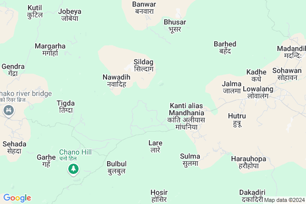
Bhangia Map
EDIT Map
Add Your House
 ..
..
Current Corona Virus Infected Patients Count in Chatra District
| City Name | District Name | Total Covid cases |
|---|
Locality Name :
Bhangia
( भंगिआ )
Block Name : Lawalong
District : Chatra
State : Jharkhand
Language : Magahi and Nagpuri,khortha,hindi And Urdu
Current Time 10:57 AM
Date: Wednesday , Apr 30,2025 (IST)
Time zone: IST (UTC+5:30)
Elevation / Altitude: 515 meters. Above Seal level
Telephone Code / Std Code: 06559
Assembly constituency : Simaria assembly constituency
Assembly MLA : Kishun Kumar Das
Lok Sabha constituency : Chatra parliamentary constituency
Parliament MP : SUNIL KUMAR SINGH
Serpanch Name :
Pin Code : 825401
Post Office Name : Chatra (Chatra)
Main Village Name : Bhangia
Commodities Prices : Lohardaga Market / Mandi
Bhangia Live Weather
Temperature: 35.9 °C
clear sky
Humidity: 23%
Wind : 0.53 mt/sec towards N
StationName : "ChatrÄ\u0081"
observed on Now
Temperature: 35.9 °C
clear sky
Humidity: 23%
Wind : 0.53 mt/sec towards N
StationName : "ChatrÄ\u0081"
observed on Now
Bhangia Weather Forecast for Next 5 days
01-05-2025
25.0°C to 37.8°C
clear sky, light rain
25.0°C to 37.8°C
clear sky, light rain
02-05-2025
23.5°C to 39.1°C
clear sky, light rain, broken clouds, scattered clouds
23.5°C to 39.1°C
clear sky, light rain, broken clouds, scattered clouds
03-05-2025
22.6°C to 38.8°C
scattered clouds, clear sky, few clouds, light rain, broken clouds
22.6°C to 38.8°C
scattered clouds, clear sky, few clouds, light rain, broken clouds
04-05-2025
25.1°C to 39.6°C
scattered clouds, clear sky, light rain, broken clouds
25.1°C to 39.6°C
scattered clouds, clear sky, light rain, broken clouds
05-05-2025
25.4°C to 40.9°C
clear sky, scattered clouds, broken clouds, few clouds
25.4°C to 40.9°C
clear sky, scattered clouds, broken clouds, few clouds
Rivers Near Bhangia
Jinjoi River
Jatia River
Jinjoi River
Jatia River
About Bhangia
Correct below Info and add more info about BhangiaBhangia is a small Village/hamlet in Lawalong Block in Chatra District of Jharkhand State, India. It comes under Bhangia Panchayath. It is located 29 KM towards west from District head quarters Chatra. 9 KM from Lawalong. 121 KM from State capital Ranchi
Bhangia Pin code is 825401 and postal head office is Chatra (Chatra).
Rimi ( 12 KM ) , Kolkole Kala ( 13 KM ) , Sikidag ( 17 KM ) are the nearby Villages to Bhangia. Bhangia is surrounded by Kunda Block towards North , Panki Block towards west , Balumath Block towards South , Pratappur Block towards North .
Chatra , Sherghati , Churi , Daltonganj are the near by Cities to Bhangia.
Bhangia 2011 Census Details
Bhangia Local Language is Magahi. Bhangia Village Total population is 10 and number of houses are 1. Female Population is 30.0%. Village literacy rate is 60.0% and the Female Literacy rate is 10.0%.
Population
| Census Parameter | Census Data |
| Total Population | 10 |
| Total No of Houses | 1 |
| Female Population % | 30.0 % ( 3) |
| Total Literacy rate % | 60.0 % ( 6) |
| Female Literacy rate | 10.0 % ( 1) |
| Scheduled Tribes Population % | 100.0 % ( 10) |
| Scheduled Caste Population % | 0.0 % ( 0) |
| Working Population % | 60.0 % |
| Child(0 -6) Population by 2011 | 1 |
| Girl Child(0 -6) Population % by 2011 | 0.0 % ( 0) |
Bhangia Census More Deatils.
Politics in Bhangia
JVM , Bharatiya Janata Party , BJP , JMM , JVMP , INC are the major political parties in this area.Polling Stations /Booths near Bhangia
1)U.m.s Nongaown (west)2)U.m.s. Rimi North
3)U.m.s. Tonatand
4)Panchayat Bhawan Edala (east)
5)Panchayat Bhawan Simariya
HOW TO REACH Bhangia
By Rail
There is no railway station near to Bhangia in less than 10 km.Colleges near Bhangia
Bhadrarkali Enter Collage Itkhori
Address :
No Colleage In This Villeage
Address :
Vananchal College
Address :
Schools near Bhangia
Govt Health Centers near Bhangia
1) HSC MANDHANIYA , , Mandhaniya ,2) HSC LAMIPATRA , LAMIPATRA HSC , LAMIPATRA , LAMIPATRA HSC
3) PHC LAWALONG , , Lawalong ,
Sub Villages in Bhangia
Local Parks in Bhangia,Lawalong
Governement Offices near Bhangia,Lawalong
About Bhangia &
History
How to reach Bhangia
Tourist Places Near By Bhangia
Schools in Bhangia
Colleges in Bhangia
Temperature & weather of Bhangia
places in Bhangia
Bhangia photos
More Information
How to reach Bhangia
Tourist Places Near By Bhangia
Schools in Bhangia
Colleges in Bhangia
Temperature & weather of Bhangia
places in Bhangia
Bhangia photos
More Information
Village Talk
Post News or Events about this Village
Near Cities
Chatra 28 KM near
Sherghati 63 KM near
Churi 63 KM near
Daltonganj 67 KM near
Chatra 28 KM near
Sherghati 63 KM near
Churi 63 KM near
Daltonganj 67 KM near
Near By Taluks
Lawalong 9 KM near
Kunda 15 KM near
Panki 23 KM near
Balumath 27 KM near
Lawalong 9 KM near
Kunda 15 KM near
Panki 23 KM near
Balumath 27 KM near
Near By Air Ports
Gaya Airport 89 KM near
Ranchi Airport 119 KM near
Patna Airport 195 KM near
Varanasi Airport 267 KM near
Gaya Airport 89 KM near
Ranchi Airport 119 KM near
Patna Airport 195 KM near
Varanasi Airport 267 KM near
Near By Tourist Places
Chatra 28 KM near
Latehar 45 KM near
Palamu 46 KM near
Betla National Park 56 KM near
Lohardaga 79 KM near
Chatra 28 KM near
Latehar 45 KM near
Palamu 46 KM near
Betla National Park 56 KM near
Lohardaga 79 KM near
Near By Districts
Chatra 28 KM near
Latehar 45 KM near
Palamu 68 KM near
Lohardaga 79 KM near
Chatra 28 KM near
Latehar 45 KM near
Palamu 68 KM near
Lohardaga 79 KM near
Near By RailWay Station
Latehar Rail Way Station 48 KM near
Tori Junction Rail Way Station 49 KM near
Latehar Rail Way Station 48 KM near
Tori Junction Rail Way Station 49 KM near