| Home | City Bus | Maps | Villages | Cities | Rail | Tourist Places | School | College | Pin Codes | Corona Cases Count |
| Distance Calculator Bus Services IFSC Codes Trace Mobile Number Weather Search Place Trace IP Available Cash ATM/Banks Locate Polling Booth Report an Error contact People |
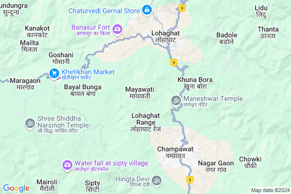
Mayawati
Mayawati Map
EDIT Map
Add Your House
 ..
..
Current Corona Virus Infected Patients Count in Champawat District
| City Name | District Name | Total Covid cases |
|---|
Locality Name :
Mayawati
( मायावती )
Block Name : Lohaghat
District : Champawat
State : Uttarakhand
Language : Hindi and Urdu
Current Time 10:51 AM
Date: Friday , Apr 25,2025 (IST)
Time zone: IST (UTC+5:30)
Elevation / Altitude: 258 meters. Above Seal level
Telephone Code / Std Code: 05965
Assembly constituency : Lohaghat assembly constituency
Assembly MLA : Khushal Singh Adhikari
Lok Sabha constituency : Almora parliamentary constituency
Parliament MP : Ajay Tamta
Serpanch Name :
Pin Code : 262524
Post Office Name : Lohaghat
Main Village Name : Mayawati
Commodities Prices : Khateema Market / Mandi
Mayawati Live Weather
Temperature: 18.9 °C
clear sky
Humidity: 15%
Wind : 2.3 mt/sec towards N
StationName : "LohaghÄ\u0081t"
observed on 2 Hours Back
Temperature: 18.9 °C
clear sky
Humidity: 15%
Wind : 2.3 mt/sec towards N
StationName : "LohaghÄ\u0081t"
observed on 2 Hours Back
Mayawati Weather Forecast for Next 5 days
26-04-2025
14.5°C to 30.7°C
clear sky, few clouds, scattered clouds
14.5°C to 30.7°C
clear sky, few clouds, scattered clouds
27-04-2025
14.6°C to 31.6°C
broken clouds, overcast clouds
14.6°C to 31.6°C
broken clouds, overcast clouds
28-04-2025
13.4°C to 29.9°C
overcast clouds, broken clouds, few clouds
13.4°C to 29.9°C
overcast clouds, broken clouds, few clouds
29-04-2025
13.8°C to 29.5°C
overcast clouds, broken clouds, light rain
13.8°C to 29.5°C
overcast clouds, broken clouds, light rain
30-04-2025
13.2°C to 28.9°C
broken clouds, overcast clouds, light rain, heavy intensity rain
13.2°C to 28.9°C
broken clouds, overcast clouds, light rain, heavy intensity rain
National Highways Reachable To Mayawati
Nationa High Way :NH309A
Nationa High Way :NH109
Nationa High Way :NH309A
Nationa High Way :NH109
Rivers Near Mayawati
:काली गाड Sharda :Mahakali River :शारदा नदी :महाकाली नदी
:काली गाड Sharda :Mahakali River :शारदा नदी :महाकाली नदी
:काली गाड Sharda :Mahakali River :शारदा नदी :महाकाली नदी
:काली गाड Sharda :Mahakali River :शारदा नदी :महाकाली नदी
About Mayawati
Correct below Info and add more info about MayawatiMayawati is a small Village/hamlet in Lohaghat Block in Champawat District of Uttarakhand State, India. It comes under Mayawati Panchayath. It is located 6 KM towards North from District head quarters Champawat. 11 KM from Lohaghat. 260 KM from State capital Dehradun
Mayawati Pin code is 262524 and postal head office is Lohaghat .
Digdai ( 3 KM ) , Bandela Dek ( 3 KM ) , Kolidek ( 4 KM ) , Khuna Bora ( 4 KM ) , Lohaghat ( 4 KM ) are the nearby Villages to Mayawati. Mayawati is surrounded by Lohaghat Block towards East , Champawat Block towards South , Pati Block towards west , Pithoragarh Block towards North .
Champawat , Pithoragarh , Almora , Haldwani are the near by Cities to Mayawati.
Mayawati 2011 Census Details
Mayawati Local Language is Hindi. Mayawati Village Total population is 9 and number of houses are 2. Female Population is 0.0%. Village literacy rate is 100.0% and the Female Literacy rate is 0.0%.
Population
| Census Parameter | Census Data |
| Total Population | 9 |
| Total No of Houses | 2 |
| Female Population % | 0.0 % ( 0) |
| Total Literacy rate % | 100.0 % ( 9) |
| Female Literacy rate | 0.0 % ( 0) |
| Scheduled Tribes Population % | 0.0 % ( 0) |
| Scheduled Caste Population % | 0.0 % ( 0) |
| Working Population % | 22.2 % |
| Child(0 -6) Population by 2011 | 0 |
| Girl Child(0 -6) Population % by 2011 | -1.0 % ( 0) |
Mayawati Census More Deatils.
Politics in Mayawati
BJP , BJP , INC are the major political parties in this area.Polling Stations /Booths near Mayawati
1)Bagauti2)Banauli
3)Ezatadungra
4)Khetikhan R.n. 2
5)Jaulari
HOW TO REACH Mayawati
By Rail
There is no railway station near to Mayawati in less than 10 km.Schools near Mayawati
Rajeev Gandhi Navoday Vidyalaya
Address : raikotmahar , lohaghat , champawat , Uttarakhand . PIN- 262524 , Post - Lohaghat
Ups Kimtoli
Address : kimtoli , lohaghat , champawat , Uttarakhand . PIN- 262524 , Post - Lohaghat
Vevekanand Vm Lohaghat
Address : lohaghat , lohaghat , champawat , Uttarakhand . PIN- 262524 , Post - Lohaghat
Vevekanand Vm Lohaghat Ups
Address : lohaghat , lohaghat , champawat , Uttarakhand . PIN- 262524 , Post - Lohaghat
Govt Health Centers near Mayawati
1) Mau , SC Mau , Mau ,2) Irakote , , ,
3) Quinti , Quity , Quity ,
Sub Villages in Mayawati
Hospitals in Mayawati,Lohaghat
Govenment Veterinary Hospital
Lohaghat Range; Lohaghat; Uttarakhand 262524; India
4.1 KM distance Detail
more ..
Petrol Bunks in Mayawati,Lohaghat
Parvati Petrol Pump
NH125; Lohaghat Range; Lohaghat; Uttarakhand 262524; India
3.8 KM distance Detail
Punetha Petrol Pump
NH-125; NH 125; Lohaghat Range; Champawat; Uttarakhand 262523; India
4.3 KM distance Detail
more ..
Colleges in Mayawati,Lohaghat
Government Post Graduation College
Degree College Rd; Rai Nagar; Lohaghat; Uttarakhand 262524; India
4.2 KM distance Detail
more ..
Schools in Mayawati,Lohaghat
Mallikarjun Public School; Lohaghat
Near Gas Bhandar; Lohaghat Range; Lohaghat; Uttarakhand 262524; India
4.0 KM distance Detail
Excellent Study Centre Lohaghat
near Lohawati Printing Press Khadi Bazar; Lohaghat; Uttarakhand 262524; India
4.4 KM distance Detail
Kedriya Vidyalaya Lohaghat; District Champawat
Lohaghat Range; Lohaghat; Uttarakhand 262524; India
4.5 KM distance Detail
Government Primary School
Lohaghat Range; Lohaghat; Uttarakhand 262524; India
4.5 KM distance Detail
Electronic Shops in Mayawati,Lohaghat
Shri Sai Digital Mall
Dak Bangla Rd; Lohaghat Range; Lohaghat; Uttarakhand 262524; India
4.1 KM distance Detail
Super Markets in Mayawati,Lohaghat
Mahesh General Store Dakbangla Road Lohaghat
Dak Bangla Rd; Lohaghat Range; Lohaghat; Uttarakhand 262524; India
4.1 KM distance Detail
Patan Kanera Lohaghat
Uttarakhand; Patan Kanera; Khais Kande; Lohaghat; Uttarakhand 262524; India
6.2 KM distance Detail
Local Parks in Mayawati,Lohaghat
Police Stations near Mayawati,Lohaghat
Police Station Champawat
Khark Karki Road; NH 125; Champawat; Uttarakhand 262523; India
5.4 KM distance Detail
About Mayawati &
History
How to reach Mayawati
Tourist Places Near By Mayawati
Schools in Mayawati
Colleges in Mayawati
Temperature & weather of Mayawati
places in Mayawati
Mayawati photos
More Information
How to reach Mayawati
Tourist Places Near By Mayawati
Schools in Mayawati
Colleges in Mayawati
Temperature & weather of Mayawati
places in Mayawati
Mayawati photos
More Information
Village Talk
Post News or Events about this Village
Near Cities
Champawat 3 KM near
Pithoragarh 31 KM near
Almora 53 KM near
Haldwani 60 KM near
Champawat 3 KM near
Pithoragarh 31 KM near
Almora 53 KM near
Haldwani 60 KM near
Near By Taluks
Barakot 10 KM near
Lohaghat 10 KM near
Champawat 11 KM near
Pati 17 KM near
Barakot 10 KM near
Lohaghat 10 KM near
Champawat 11 KM near
Pati 17 KM near
Near By Air Ports
Pantnagar Airport 77 KM near
Dehra Dun Airport 249 KM near
Muzaffarnagar Airport 260 KM near
Amausi Airport 336 KM near
Pantnagar Airport 77 KM near
Dehra Dun Airport 249 KM near
Muzaffarnagar Airport 260 KM near
Amausi Airport 336 KM near
Near By Tourist Places
Champawat 4 KM near
Abbott Mount 8 KM near
Pithoragarh 30 KM near
Tanakpur 36 KM near
Naukuchiatal 46 KM near
Champawat 4 KM near
Abbott Mount 8 KM near
Pithoragarh 30 KM near
Tanakpur 36 KM near
Naukuchiatal 46 KM near
Near By Districts
Champawat 5 KM near
Pithoragarh 31 KM near
Almora 53 KM near
Nainital 65 KM near
Champawat 5 KM near
Pithoragarh 31 KM near
Almora 53 KM near
Nainital 65 KM near
Near By RailWay Station
Kathgodam Rail Way Station 58 KM near
Haldwani Rail Way Station 61 KM near
Kathgodam Rail Way Station 58 KM near
Haldwani Rail Way Station 61 KM near