| Home | City Bus | Maps | Villages | Cities | Rail | Tourist Places | School | College | Pin Codes | Corona Cases Count |
| Distance Calculator Bus Services IFSC Codes Trace Mobile Number Weather Search Place Trace IP Available Cash ATM/Banks Locate Polling Booth Report an Error contact People |
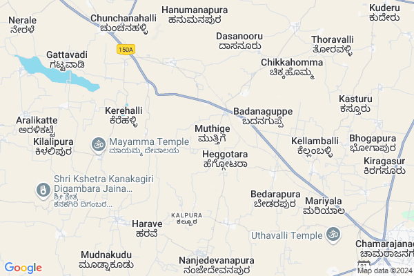
Muthige
Muthige Map
EDIT Map
Add Your House
 ..
..
Current Corona Virus Infected Patients Count in Chamarajanagar District
| City Name | District Name | Total Covid cases |
|---|
Locality Name :
Muthige
( ಮೂತಿಗೆ )
Taluk Name : Chamarajanagar
District : Chamarajanagar
State : Karnataka
Division : Mysore
Language : Kannada
Current Time 05:39 AM
Date: Saturday , Apr 26,2025 (IST)
Time zone: IST (UTC+5:30)
Elevation / Altitude: 736 meters. Above Seal level
Telephone Code / Std Code: 08229
Assembly constituency : Chamarajanagar assembly constituency
Assembly MLA : C. Puttarangashetty
Lok Sabha constituency : Chamarajanagar parliamentary constituency
Parliament MP : V. SRINIVAS PRASAD
Serpanch Name :
Main Village Name : Muthige
Commodities Prices : Chamaraj Nagar Market / Mandi
Muthige Live Weather
Temperature: 23.9 °C
overcast clouds
Humidity: 73%
Wind : 0.97 mt/sec towards SW
StationName : "Chamrajnagar"
observed on 51 Mins Back
Temperature: 23.9 °C
overcast clouds
Humidity: 73%
Wind : 0.97 mt/sec towards SW
StationName : "Chamrajnagar"
observed on 51 Mins Back
Muthige Weather Forecast for Next 5 days
27-04-2025
23.5°C to 36.0°C
overcast clouds
23.5°C to 36.0°C
overcast clouds
28-04-2025
23.4°C to 36.6°C
overcast clouds, light rain
23.4°C to 36.6°C
overcast clouds, light rain
29-04-2025
23.5°C to 35.8°C
broken clouds, scattered clouds, few clouds, light rain, overcast clouds
23.5°C to 35.8°C
broken clouds, scattered clouds, few clouds, light rain, overcast clouds
30-04-2025
23.3°C to 34.6°C
overcast clouds, light rain
23.3°C to 34.6°C
overcast clouds, light rain
National Highways Reachable To Muthige
Nationa High Way :NH544
Nationa High Way :NH275
Nationa High Way :NH544
Nationa High Way :NH275
Rivers Near Muthige
Chikkahole :ಚಿಕ್ಕಹೊಳೆ
Chikkahole :ಚಿಕ್ಕಹೊಳೆ
About Muthige
Correct below Info and add more info about MuthigeMuthige is a small Village/hamlet in Chamarajanagar Taluk in Chamarajanagar District of Karnataka State, India. It comes under Muthige Panchayath. It belongs to Mysore Division . It is located 12 KM towards west from District head quarters Chamarajanagara. 12 KM from Chamarajanagar. 159 KM from State capital Bangalore
Harave ( 7 KM ) , Mukkadahalli ( 7 KM ) , Nanjedevanapura ( 8 KM ) , Maliyuru ( 9 KM ) , Shivapura ( 10 KM ) are the nearby Villages to Muthige. Muthige is surrounded by Nanjangud Taluk towards west , Yelandur Taluk towards East , Gundlupet Taluk towards South , Tirumakudal-Narsipur Taluk towards North .
Nanjangud , Gundlupet , Mysore , Chamrajnagar are the near by Cities to Muthige.
This Place is in the border of the Chamarajanagar District and Erode District. Erode District Talavadi is South towards this place . It is near to the Tamil Nadu State Border.
Muthige 2011 Census Details
Muthige Local Language is Kannada. Muthige Village Total population is 1466 and number of houses are 356. Female Population is 51.4%. Village literacy rate is 57.8% and the Female Literacy rate is 26.4%.
Population
| Census Parameter | Census Data |
| Total Population | 1466 |
| Total No of Houses | 356 |
| Female Population % | 51.4 % ( 753) |
| Total Literacy rate % | 57.8 % ( 848) |
| Female Literacy rate | 26.4 % ( 387) |
| Scheduled Tribes Population % | 0.0 % ( 0) |
| Scheduled Caste Population % | 17.9 % ( 263) |
| Working Population % | 47.5 % |
| Child(0 -6) Population by 2011 | 136 |
| Girl Child(0 -6) Population % by 2011 | 49.3 % ( 67) |
Muthige Census More Deatils.
Politics in Muthige
Indian National Congress (INC) is the major political party in this area.Polling Stations /Booths near Muthige
1)Govt. Higher Primary School Handrakalli2)Govt Higher Primary School (south) Room No 2 Kottalavadi
3)Govt Higher Primary School Heggathara
4)Govt Higher Primary School Nijalinganapura
5)Govt Higher Primary School Melajipura
HOW TO REACH Muthige
By Road
Chamrajnagar is the Nearest Town to Muthige. Road connectivity is there from Chamrajnagar to Muthige.By Rail
Badanaguppe Rail Way Station , Konanur Rail Way Station are the very nearby railway stations to Muthige.Pincodes near Muthige
571313 ( Zilla Adalitha Bhavan ) , 571128 ( Harave ) , 571316 ( Kuderu (Chamrajnagar) )Colleges near Muthige
Jss D.ed College
Address :
G Ov't P U College
Address :
Sarkari Sangashatty Padavi Purva College
Address :
Schools near Muthige
Hps Morarji Santhemarahalli
Address : santhe marahalli , chamaraja nagar , chamarajanagara , Karnataka . PIN- 571115 , Post - Santhemaranahalli
Hs Jawaharnavodaya Honarabalu
Address : hondarabalu , chamaraja nagar , chamarajanagara , Karnataka . PIN- 571342 , Post - Ramasamudra (Chamrajnagar)
Mcs Hps Somavarapete
Address : somavarapet , chamaraja nagar , chamarajanagara , Karnataka . PIN- 571313 , Post - Zilla Adalitha Bhavan
Dheenabandhu Hps Ch.nagar
Address : chama-rajnagar , chamaraja nagar , chamarajanagara , Karnataka . PIN- 571342 , Post - Ramasamudra (Chamrajnagar)
Govt Health Centers near Muthige
1) PANYADAHUNDI , Sub Center Panyadahundi , ,2) NANJEDEVANAPURA , 879237939 Nanjedevanapura , ,
3) CHAMARAJANAGAR DH , District Hospital, , B.R Double Road , Near Pachappa circle
Sub Villages in Muthige
Schools in Muthige,Chamarajanagar
Electronic Shops in Muthige,Chamarajanagar
Super Markets in Muthige,Chamarajanagar
Local Parks in Muthige,Chamarajanagar
Police Stations near Muthige,Chamarajanagar
Governement Offices near Muthige,Chamarajanagar
About Muthige &
History
How to reach Muthige
Tourist Places Near By Muthige
Schools in Muthige
Colleges in Muthige
Temperature & weather of Muthige
places in Muthige
Muthige photos
More Information
How to reach Muthige
Tourist Places Near By Muthige
Schools in Muthige
Colleges in Muthige
Temperature & weather of Muthige
places in Muthige
Muthige photos
More Information
Village Talk
Post News or Events about this Village
Near Cities
Nanjangud 27 KM near
Gundlupet 29 KM near
Mysore 48 KM near
Chamrajnagar 54 KM near
Nanjangud 27 KM near
Gundlupet 29 KM near
Mysore 48 KM near
Chamrajnagar 54 KM near
Near By Taluks
Chamarajanagar 11 KM near
Nanjangud 23 KM near
Gundlupet 27 KM near
Yelandur 27 KM near
Chamarajanagar 11 KM near
Nanjangud 23 KM near
Gundlupet 27 KM near
Yelandur 27 KM near
Near By Air Ports
Mysore Airport 46 KM near
Peelamedu Airport 120 KM near
Calicut Airport 151 KM near
Salem Airport 165 KM near
Mysore Airport 46 KM near
Peelamedu Airport 120 KM near
Calicut Airport 151 KM near
Salem Airport 165 KM near
Near By Tourist Places
Nanjangud 27 KM near
Mysore 47 KM near
BR Hills 53 KM near
Shivanasamundram 53 KM near
Srirangapatna 56 KM near
Nanjangud 27 KM near
Mysore 47 KM near
BR Hills 53 KM near
Shivanasamundram 53 KM near
Srirangapatna 56 KM near
Near By Districts
Chamarajanagar 12 KM near
Mysore 48 KM near
Mandya 68 KM near
The Nilgiris 73 KM near
Chamarajanagar 12 KM near
Mysore 48 KM near
Mandya 68 KM near
The Nilgiris 73 KM near
Near By RailWay Station
Badanaguppe Rail Way Station 2.7 KM near
Konanur Rail Way Station 7.5 KM near
Mysuru Junction Rail Way Station 48 KM near
Shrirangapattana Rail Way Station 59 KM near
Badanaguppe Rail Way Station 2.7 KM near
Konanur Rail Way Station 7.5 KM near
Mysuru Junction Rail Way Station 48 KM near
Shrirangapattana Rail Way Station 59 KM near