| Home | City Bus | Maps | Villages | Cities | Rail | Tourist Places | School | College | Pin Codes | Corona Cases Count |
| Distance Calculator Bus Services IFSC Codes Trace Mobile Number Weather Search Place Trace IP Available Cash ATM/Banks Locate Polling Booth Report an Error contact People |
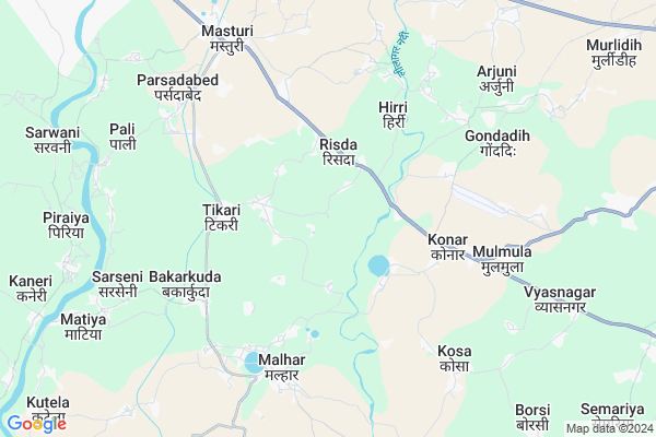
Dodki
Dodki Map
EDIT Map
Add Your House
 ..
..
Current Corona Virus Infected Patients Count in Bilaspur District
| City Name | District Name | Total Covid cases |
|---|---|---|
| Bilaspur | Bilaspur | 1 |
Locality Name :
Dodki
( डोड़की )
Tehsil Name : Belha
District : Bilaspur
State : Chattisgarh
Language : Chhattisgarhi and Hindi, Agariya, Bagheli
Current Time 09:29 AM
Date: Wednesday , Apr 30,2025 (IST)
Time zone: IST (UTC+5:30)
Elevation / Altitude: 268 meters. Above Seal level
Telephone Code / Std Code: 07752
Assembly constituency : Masturi assembly constituency
Assembly MLA : Dilip Lahariya
Lok Sabha constituency : Bilaspur parliamentary constituency
Parliament MP : ARUN SAO
Serpanch Name :
Main Village Name : DODKI
Commodities Prices : Jairamnagar Market / Mandi
Rivers Near Dodki
Lilagar
Hasdeo :Hasdeo River
Lilagar
Hasdeo :Hasdeo River
About Dodki
Correct below Info and add more info about DodkiDodki is a small Village/hamlet in Belha Tehsil in Bilaspur District of Chattisgarh State, India. It comes under DODKI Panchayath. It is located 23 KM towards East from District head quarters Bilaspur. 20 KM from Belha. 121 KM from State capital Raipur
Tikari ( 4 KM ) , Mudpar ( 5 KM ) , Malhar ( 6 KM ) , Bakarkuda ( 6 KM ) , Budhikhar ( 7 KM ) are the nearby Villages to Dodki. Dodki is surrounded by Pamgarh Tehsil towards East , Akaltara Tehsil towards East , Belha Tehsil towards west , Bilaspur Tehsil towards west .
Akaltara , Bilaspur , Bilaspur , Naila Janjgir are the near by Cities to Dodki.
Dondki 2011 Census Details
Dodki Local Language is Chhattisgarhi. Dondki Village Total population is 865 and number of houses are 200. Female Population is 48.7%. Village literacy rate is 46.9% and the Female Literacy rate is 20.0%.
Population
| Census Parameter | Census Data |
| Total Population | 865 |
| Total No of Houses | 200 |
| Female Population % | 48.7 % ( 421) |
| Total Literacy rate % | 46.9 % ( 406) |
| Female Literacy rate | 20.0 % ( 173) |
| Scheduled Tribes Population % | 0.0 % ( 0) |
| Scheduled Caste Population % | 75.7 % ( 655) |
| Working Population % | 32.8 % |
| Child(0 -6) Population by 2011 | 186 |
| Girl Child(0 -6) Population % by 2011 | 44.1 % ( 82) |
Dondki Census More Deatils.
Politics in Dodki
Bharatiya Janata Party , BJP , INC are the major political parties in this area.Polling Stations /Booths near Dodki
1)Dhurvakari2)Risda
3)Risda
4)Relha
5)Risda
HOW TO REACH Dodki
By Rail
There is no railway station near to Dodki in less than 10 km.Pincodes near Dodki
495663 ( Gopal Nagar ) , 495549 ( CCI Akaltara ) , 495553 ( Nariyara )Colleges near Dodki
Govt. Pataleshwar College Masturi
Address :
Institute Of Technology Guru Ghasidas University Bilaspur
Address :
Governmet Iti Takhatpur
Address :
Niranjan Kesharwani Collage
Address :
Governmet Jpm College Takhatpur
Address :
Schools in Dodki
Govt. Ps Dodkibhata
Address : dodki , bilha , bilaspur (chhattisgarh) , Chattisgarh . PIN- 495224 , Post - Bilha
Govt. Ps Dodki
Address : dodki , bilha , bilaspur (chhattisgarh) , Chattisgarh . PIN- 495001 , Post - Bilaspur (Bilaspur-CGH)
Govt Health Centers near Dodki
1) SHC Akola , , ,2) SHC Konar , Sub Health Centre Konar , Village Konar , Konar
3) SHC Arasmeta , Sub Centre Arasmeta , Block Akaltara , Tehsil Akaltara
Sub Villages in Dodki
Hospitals in Dodki,Belha
Mahamaya Dant Chikitsalay
National Highway 49; Sargawan; Chhattisgarh 495551; India
7.2 KM distance Detail
more ..
Petrol Bunks in Dodki,Belha
HP PETROL PUMP - ASHIRVAD SERVICE STATION
HP Petrol Pump Village Mulmula District; NH200; Raipur; Chhattisgarh 495663; India
4.7 KM distance Detail
more ..
Colleges in Dodki,Belha
Govt.college Masturi
Masturi - Jairamnagar Road; Masturi; Chhattisgarh 495550; India
7.6 KM distance Detail
more ..
Schools in Dodki,Belha
Primary School
Schoolpara; Dipa Para; Kukurdi Kalan; Chhattisgarh 495663; India
2.9 KM distance Detail
Electronic Shops in Dodki,Belha
PS Mobile Electronics & General Store
Gopal Nagar; PO Konargarh; Konar; Chhattisgarh 495663; India
3.0 KM distance Detail
Super Markets in Dodki,Belha
जय माता दी वेल्डिंग वर्कशॉप
Malhar Express Way; Parsadabed; Chhattisgarh 495551; India
6.5 KM distance Detail
About Dodki &
History
How to reach Dodki
Tourist Places Near By Dodki
Schools in Dodki
Colleges in Dodki
Temperature & weather of Dodki
places in Dodki
Dodki photos
More Information
How to reach Dodki
Tourist Places Near By Dodki
Schools in Dodki
Colleges in Dodki
Temperature & weather of Dodki
places in Dodki
Dodki photos
More Information
Village Talk
Post News or Events about this Village
Near Cities
Akaltara 17 KM near
Bilaspur 25 KM near
Bilaspur 27 KM near
Naila Janjgir 32 KM near
Akaltara 17 KM near
Bilaspur 25 KM near
Bilaspur 27 KM near
Naila Janjgir 32 KM near
Near By Taluks
Masturi 6 KM near
Belha 18 KM near
Pamgarh 18 KM near
Akaltara 19 KM near
Masturi 6 KM near
Belha 18 KM near
Pamgarh 18 KM near
Akaltara 19 KM near
Near By Air Ports
Raipur Airport 114 KM near
Jabalpur Airport 288 KM near
Ranchi Airport 387 KM near
Sonegaon Airport 390 KM near
Raipur Airport 114 KM near
Jabalpur Airport 288 KM near
Ranchi Airport 387 KM near
Sonegaon Airport 390 KM near
Near By Tourist Places
Bilaspur 25 KM near
Janjgir-Champa 32 KM near
Janjgir 33 KM near
Korba 67 KM near
Mahasamund 106 KM near
Bilaspur 25 KM near
Janjgir-Champa 32 KM near
Janjgir 33 KM near
Korba 67 KM near
Mahasamund 106 KM near
Near By Districts
Bilaspur 22 KM near
Janjgir-Champa 58 KM near
Korba 68 KM near
Mahasamund 106 KM near
Bilaspur 22 KM near
Janjgir-Champa 58 KM near
Korba 68 KM near
Mahasamund 106 KM near
Near By RailWay Station
Akaltara Rail Way Station 18 KM near
Bilaspur Junction Rail Way Station 21 KM near
Akaltara Rail Way Station 18 KM near
Bilaspur Junction Rail Way Station 21 KM near