| Home | City Bus | Maps | Villages | Cities | Rail | Tourist Places | School | College | Pin Codes | Corona Cases Count |
| Distance Calculator Bus Services IFSC Codes Trace Mobile Number Weather Search Place Trace IP Available Cash ATM/Banks Locate Polling Booth Report an Error contact People |
Jarot
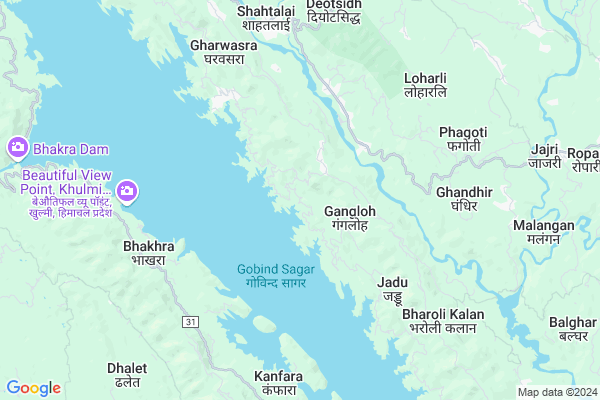
Jarot Map
EDIT Map
Add Your House
 ..
..
Current Corona Virus Infected Patients Count in Bilaspur District District
| City Name | District Name | Total Covid cases |
|---|
Locality Name :
Jarot
( जरोट )
Tehsil Name : Ghumarwin
District : Bilaspur District
State : Himachal Pradesh
Language : Hindi
Current Time 03:23 PM
Date: Tuesday , Apr 29,2025 (IST)
Time zone: IST (UTC+5:30)
Elevation / Altitude: 375 meters. Above Seal level
Telephone Code / Std Code: 01978
Assembly constituency : Jhanduta assembly constituency
Assembly MLA : Jeet Ram Katwal
Lok Sabha constituency : Hamirpur parliamentary constituency
Parliament MP : ANURAG SINGH THAKUR
Serpanch Name :
Pin Code : 174030
Post Office Name : Tallai
Main Village Name : Jarot
Commodities Prices : Anandpur Sahib Market / Mandi
National Highways Reachable To Jarot
Nationa High Way :NH205
Nationa High Way :NH503A
Nationa High Way :NH205
Nationa High Way :NH503A
Rivers Near Jarot
Sutlej :Sutlej River :सतलुज नदी :ਸਤਲੁਜ :ستلج
Bakhli Khad
Sutlej :Sutlej River :सतलुज नदी :ਸਤਲੁਜ :ستلج
Bakhli Khad
About Jarot
Correct below Info and add more info about JarotJarot is a small Village/hamlet in Ghumarwin Tehsil in Bilaspur District District of Himachal Pradesh State, India. It comes under Jarot Panchayath. It is located 27 KM towards west from District head quarters Bilaspur,. 17 KM from Ghumarwin. 81 KM from State capital Shimla
Jarot Pin code is 174030 and postal head office is Tallai .
Bhakhra ( 6 KM ) , Saloa ( 7 KM ) , Naghiar ( 7 KM ) , Bakroa ( 7 KM ) , Bharoli Kalan ( 7 KM ) are the nearby Villages to Jarot. Jarot is surrounded by Ghumarwin Tehsil towards East , Bijhri Tehsil towards North , Anandpur Sahib Tehsil towards South , Una Tehsil towards west .
Nangal , Hamirpur , Sundarnagar , Rupnagar are the near by Cities to Jarot.
This Place is in the border of the Bilaspur District District and Hamirpur District. Hamirpur District Bijhri is North towards this place . Also it is in the Border of other district Mandi .
Demographics of Jarot
Hindi is the Local Language here.Politics in Jarot
Bharatiya Janata Party , BJP , INC are the major political parties in this area.Polling Stations /Booths near Jarot
1)G.m.s.-serwa2)G.h.s.-dhani
3)G.p.s.- Dholag Chaknad
4)G.s.s.s.-dhanthar
5)G.h.s.-jabalu
HOW TO REACH Jarot
By Rail
There is no railway station near to Jarot in less than 10 km.Colleges near Jarot
G.d.c. Jukhala
Address :
Schools near Jarot
Gsss Barota
Address : barota , ghumarwin-i , bilaspur (h.p.) , Himachal Pradesh . PIN- 174027 , Post - Lehri Sarail
Shiksha Academy Pub.sch. Ghumarwin
Address : ghumarwin , ghumarwin-ii , bilaspur (h.p.) , Himachal Pradesh . PIN- 174001 , Post - Bilaspur (Bilaspur- HP)
Gsss Malyawer
Address : malyawar , ghumarwin-ii , bilaspur (h.p.) , Himachal Pradesh . PIN- 174004 , Post - Kandraur
Gsss Marhana
Address : marhana , ghumarwin-i , bilaspur (h.p.) , Himachal Pradesh . PIN- 174028 , Post - Hatwar
Govt Health Centers near Jarot
1) Karer SC , VPO Karer Tehsil Barsar Distt. Hamirpur H.P. , Karer ,2) Dhaned Seribaloni PHC , VPO Dhaned Tehsil &Distt. Hamirpur H.P. , Dhaned ,
3) Phahal SC , V.P.O. Phahal Tehsil Nadaun Distt. Hamirpur H.P. , Phahal ,
Sub Villages in Jarot
Petrol Bunks in Jarot,Ghumarwin
Shahid Ashawani Chandel Filling Station
Sargal; Himachal Pradesh 174029; India
13.8 KM distance Detail
more ..
Colleges in Jarot,Ghumarwin
Government Degree College Jhandutta
Jhanduta Awal; Himachal Pradesh 174031; India
12.4 KM distance Detail
BIT INSTITUTE BERTHIN
Bus Stop; Berthin; Berthin; Himachal Pradesh 174029; India
12.6 KM distance Detail
Government Industrial Training Institute
Sunhani-Berthin Rd; Berthin; Himachal Pradesh 174029; India
13.9 KM distance Detail
Shri Saraswati Sanskrit Degree College
Nihari - Dadhol Kalan Rd; Dangar; Himachal Pradesh 174023; India
19.1 KM distance Detail
more ..
Schools in Jarot,Ghumarwin
Government High School
Berthin-Deotsidh Rd; Gharann; Himachal Pradesh 174030; India
1.7 KM distance Detail
Super Markets in Jarot,Ghumarwin
R/c Hardware Store
Padyalag Chowk; Shimla-Kangra Rd; Chumarwin; Himachal Pradesh 174023; India
19.5 KM distance Detail
Local Parks in Jarot,Ghumarwin
Reserved Forest Area Ghumarwin
Ghumarwin-Berthin-Talai-Bhakra Rd; Ghumarwin; Himachal Pradesh 174021; India
20.1 KM distance Detail
Police Stations near Jarot,Ghumarwin
Sub Divisional Police Officer
Ghumarwin Link Rd; Ghumarwin; Himachal Pradesh 174021; India
20.1 KM distance Detail
Ghumarwin Police Station
Tehsil Rd; Bilaspur; Ghumarwin; Himachal Pradesh 174021; India
20.5 KM distance Detail
Governement Offices near Jarot,Ghumarwin
Cooperative Society Bharoli Kalan
Bhater Kalan; Himachal Pradesh 174030; India
7.5 KM distance Detail
About Jarot &
History
How to reach Jarot
Tourist Places Near By Jarot
Schools in Jarot
Colleges in Jarot
Temperature & weather of Jarot
places in Jarot
Jarot photos
More Information
How to reach Jarot
Tourist Places Near By Jarot
Schools in Jarot
Colleges in Jarot
Temperature & weather of Jarot
places in Jarot
Jarot photos
More Information
Village Talk
Post News or Events about this Village
Near Cities
Nangal 16 KM near
Hamirpur 34 KM near
Sundarnagar 41 KM near
Rupnagar 49 KM near
Nangal 16 KM near
Hamirpur 34 KM near
Sundarnagar 41 KM near
Rupnagar 49 KM near
Near By Taluks
Jhandutta 12 KM near
Ghumarwin 16 KM near
Anandpur Sahib 17 KM near
Bijhri 17 KM near
Jhandutta 12 KM near
Ghumarwin 16 KM near
Anandpur Sahib 17 KM near
Bijhri 17 KM near
Near By Air Ports
Simla Airport 74 KM near
Bhuntar Airport 94 KM near
Chandigarh Airport 94 KM near
Ludhiana Airport 95 KM near
Simla Airport 74 KM near
Bhuntar Airport 94 KM near
Chandigarh Airport 94 KM near
Ludhiana Airport 95 KM near
Near By Tourist Places
Una 28 KM near
Rewalsar 43 KM near
Rupnagar 54 KM near
Nawanshehar 55 KM near
Mandi 58 KM near
Una 28 KM near
Rewalsar 43 KM near
Rupnagar 54 KM near
Nawanshehar 55 KM near
Mandi 58 KM near
Near By Districts
Bilaspur District 25 KM near
Una 28 KM near
Hamirpur 35 KM near
Rupnagar 54 KM near
Bilaspur District 25 KM near
Una 28 KM near
Hamirpur 35 KM near
Rupnagar 54 KM near
Near By RailWay Station
Nangal Dam Rail Way Station 17 KM near
Anandpur Sahib Rail Way Station 21 KM near
Nangal Dam Rail Way Station 17 KM near
Anandpur Sahib Rail Way Station 21 KM near