| Home | City Bus | Maps | Villages | Cities | Rail | Tourist Places | School | College | Pin Codes | Corona Cases Count |
| Distance Calculator Bus Services IFSC Codes Trace Mobile Number Weather Search Place Trace IP Available Cash ATM/Banks Locate Polling Booth Report an Error contact People |
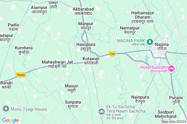
Kotawali
Kotawali Map
EDIT Map
Add Your House
 ..
..
Current Corona Virus Infected Patients Count in Bijnor District
| City Name | District Name | Total Covid cases |
|---|---|---|
| Bijnor District | Bijnor | 28 |
Locality Name :
Kotawali
( कोतवाली )
Block Name : Najibabad
District : Bijnor
State : Uttar Pradesh
Division : Moradabad
Language : Hindi and Urdu
Current Time 07:32 AM
Date: Saturday , Apr 26,2025 (IST)
Time zone: IST (UTC+5:30)
Elevation / Altitude: 269 meters. Above Seal level
Telephone Code / Std Code: 01341
Assembly constituency : Nagina assembly constituency
Assembly MLA : Manoj Kumar Paras
Lok Sabha constituency : Nagina parliamentary constituency
Parliament MP : GIRISH CHANDRA
Serpanch Name :
Main Village Name : Kotawali
Commodities Prices : Nagina Market / Mandi
Kotawali Live Weather
Temperature: 29.8 °C
scattered clouds
Humidity: 8%
Wind : 2.06 mt/sec towards E
StationName : "Nagīna"
observed on 30 Mins Back
Temperature: 29.8 °C
scattered clouds
Humidity: 8%
Wind : 2.06 mt/sec towards E
StationName : "Nagīna"
observed on 30 Mins Back
Kotawali Weather Forecast for Next 5 days
27-04-2025
28.1°C to 41.9°C
scattered clouds, broken clouds, overcast clouds
28.1°C to 41.9°C
scattered clouds, broken clouds, overcast clouds
28-04-2025
28.5°C to 42.6°C
overcast clouds, scattered clouds, broken clouds
28.5°C to 42.6°C
overcast clouds, scattered clouds, broken clouds
29-04-2025
26.9°C to 42.5°C
broken clouds, scattered clouds, few clouds, clear sky
26.9°C to 42.5°C
broken clouds, scattered clouds, few clouds, clear sky
30-04-2025
26.9°C to 41.5°C
few clouds, clear sky, broken clouds, scattered clouds
26.9°C to 41.5°C
few clouds, clear sky, broken clouds, scattered clouds
01-05-2025
27.3°C to 40.4°C
few clouds, clear sky, broken clouds, overcast clouds
27.3°C to 40.4°C
few clouds, clear sky, broken clouds, overcast clouds
National Highways Reachable To Kotawali
Nationa High Way :NH534
Nationa High Way :NH534
Rivers Near Kotawali
Solani
Khoh
Solani
Khoh
About Kotawali
Correct below Info and add more info about KotawaliKotawali is a small Village/hamlet in Najibabad Block in Bijnor District of Uttar Pradesh State, India. It comes under Kotawali Panchayath. It belongs to Moradabad Division . It is located 27 KM towards East from District head quarters Bijnor. 24 KM from Najibabad. 448 KM from State capital Lucknow
Sarai Dadumber ( 1 KM ) , Alipurmaan ( 2 KM ) , Huseinabad ( 2 KM ) , Roshanpurpratap ( 3 KM ) , Jaggannathpur ( 3 KM ) are the nearby Villages to Kotawali. Kotawali is surrounded by Kiratpur Block towards west , Nehtaur Block towards South , Haldaur(Khari Jhalu) Block towards South , Dhampur Block towards South .
Nagina , Nehtaur , Najibabad , Sherkot are the near by Cities to Kotawali.
Kotawali 2011 Census Details
Kotawali Local Language is Hindi. Kotawali Village Total population is 264 and number of houses are 56. Female Population is 46.6%. Village literacy rate is 53.0% and the Female Literacy rate is 17.4%.
Population
| Census Parameter | Census Data |
| Total Population | 264 |
| Total No of Houses | 56 |
| Female Population % | 46.6 % ( 123) |
| Total Literacy rate % | 53.0 % ( 140) |
| Female Literacy rate | 17.4 % ( 46) |
| Scheduled Tribes Population % | 0.0 % ( 0) |
| Scheduled Caste Population % | 25.4 % ( 67) |
| Working Population % | 29.2 % |
| Child(0 -6) Population by 2011 | 45 |
| Girl Child(0 -6) Population % by 2011 | 53.3 % ( 24) |
Kotawali Census More Deatils.
Politics in Kotawali
AGP , SP , BSP are the major political parties in this area.Polling Stations /Booths near Kotawali
1)Dayanand H.s.kotwali Room No22)Dayanand H.s.kotwali Room No 1
3)Bhagwandas Mangaldas V.mandirkalalan Nagina Room No1
4)Dayanand H.s.kotwali Room No 4
5)P.v.pitanheri Jhojha Khurd
HOW TO REACH Kotawali
By Rail
Nagina Rail Way Station , Puraini Rail Way Station are the very nearby railway stations to Kotawali.Colleges near Kotawali
Government Inter College
Address :
Schools in Kotawali
Ps Kotawali
Address : kotawali , najibabad , bijnor , Uttar Pradesh . PIN- 201415
Govt Health Centers near Kotawali
1) Sundarpur , Health Sub Center Bulding , Village Sundarpur ,2) Daudpur , Health Sub Center Bulding , Village Daudpur ,
3) Daudpur , Health Sub Center Bulding , Village Daudpur ,
Sub Villages in Kotawali
Schools in Kotawali,Najibabad
Electronic Shops in Kotawali,Najibabad
Super Markets in Kotawali,Najibabad
Local Parks in Kotawali,Najibabad
Police Stations near Kotawali,Najibabad
Governement Offices near Kotawali,Najibabad
About Kotawali &
History
How to reach Kotawali
Tourist Places Near By Kotawali
Schools in Kotawali
Colleges in Kotawali
Temperature & weather of Kotawali
places in Kotawali
Kotawali photos
More Information
How to reach Kotawali
Tourist Places Near By Kotawali
Schools in Kotawali
Colleges in Kotawali
Temperature & weather of Kotawali
places in Kotawali
Kotawali photos
More Information
Village Talk
Post News or Events about this Village
Near Cities
Nagina 7 KM near
Nehtaur 13 KM near
Najibabad 22 KM near
Sherkot 25 KM near
Nagina 7 KM near
Nehtaur 13 KM near
Najibabad 22 KM near
Sherkot 25 KM near
Near By Taluks
Kotwali 8 KM near
Kiratpur 14 KM near
Nehtaur 16 KM near
Haldaur(Khari Jhalu) 20 KM near
Kotwali 8 KM near
Kiratpur 14 KM near
Nehtaur 16 KM near
Haldaur(Khari Jhalu) 20 KM near
Near By Air Ports
Muzaffarnagar Airport 75 KM near
Dehra Dun Airport 115 KM near
Pantnagar Airport 130 KM near
Indira Gandhi International Airport 175 KM near
Muzaffarnagar Airport 75 KM near
Dehra Dun Airport 115 KM near
Pantnagar Airport 130 KM near
Indira Gandhi International Airport 175 KM near
Near By Tourist Places
Hastinapur 52 KM near
Lansdowne 61 KM near
Corbett National Park 63 KM near
Haridwar 67 KM near
Kashipur 69 KM near
Hastinapur 52 KM near
Lansdowne 61 KM near
Corbett National Park 63 KM near
Haridwar 67 KM near
Kashipur 69 KM near
Near By Districts
Bijnor 26 KM near
Jyotiba Phule Nagar 66 KM near
Haridwar 67 KM near
Muzaffarnagar 71 KM near
Bijnor 26 KM near
Jyotiba Phule Nagar 66 KM near
Haridwar 67 KM near
Muzaffarnagar 71 KM near
Near By RailWay Station
Nagina Rail Way Station 7.4 KM near
Najibabad Junction Rail Way Station 21 KM near
Nagina Rail Way Station 7.4 KM near
Najibabad Junction Rail Way Station 21 KM near