| Home | City Bus | Maps | Villages | Cities | Rail | Tourist Places | School | College | Pin Codes | Corona Cases Count |
| Distance Calculator Bus Services IFSC Codes Trace Mobile Number Weather Search Place Trace IP Available Cash ATM/Banks Locate Polling Booth Report an Error contact People |
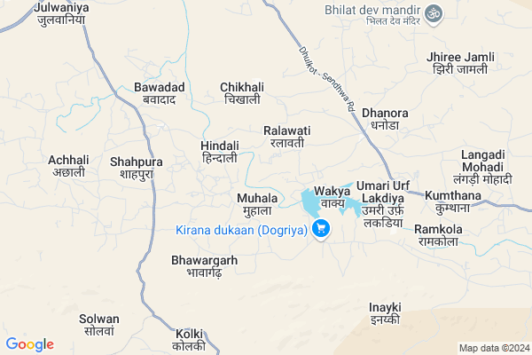
Kelpani
Kelpani Map
EDIT Map
Add Your House
 ..
..
Current Corona Virus Infected Patients Count in Barwani District
| City Name | District Name | Total Covid cases |
|---|---|---|
| Barwani District | Barwani | 24 |
Locality Name :
Kelpani
( कल्पनी )
Tehsil Name : Sendhawa
District : Barwani
State : Madhya Pradesh
Division : Indore
Language : Hindi and Bareli,devanagari,bhil
Current Time 02:14 PM
Date: Monday , Apr 28,2025 (IST)
Time zone: IST (UTC+5:30)
Telephone Code / Std Code: 07395
Assembly constituency : Sendhawa assembly constituency
Assembly MLA : Montu Solanki
Lok Sabha constituency : Khargone parliamentary constituency
Parliament MP : GAJENDRA UMRAO SINGH PATEL
Serpanch Name :
Pin Code : 451666
Post Office Name : Sendhwa
Main Village Name : Kelpani
Commodities Prices : Sendhwa Market / Mandi
Rivers Near Kelpani
Gomai
Umn
Gomai
Umn
About Kelpani
Correct below Info and add more info about KelpaniKelpani is a small Village/hamlet in Sendhawa Tehsil in Barwani District of Madhya Pradesh State, India. It comes under Kelpani Panchayath. It belongs to Indore Division . It is located 65 KM towards South from District head quarters Barwani. 342 KM from State capital Bhopal
Kelpani Pin code is 451666 and postal head office is Sendhwa .
Kelpani is surrounded by Newali Tehsil towards west , Segaon Tehsil towards North , Rajpur Tehsil towards North , Shirpur Tehsil towards west .
Sendhwa , Shirpur-Warwade , Barwani , Manawar are the near by Cities to Kelpani.
Kelpani 2011 Census Details
Kelpani Local Language is Hindi. Kelpani Village Total population is 2197 and number of houses are 261. Female Population is 49.2%. Village literacy rate is 28.3% and the Female Literacy rate is 11.6%.
Population
| Census Parameter | Census Data |
| Total Population | 2197 |
| Total No of Houses | 261 |
| Female Population % | 49.2 % ( 1081) |
| Total Literacy rate % | 28.3 % ( 621) |
| Female Literacy rate | 11.6 % ( 255) |
| Scheduled Tribes Population % | 89.5 % ( 1966) |
| Scheduled Caste Population % | 3.8 % ( 83) |
| Working Population % | 48.2 % |
| Child(0 -6) Population by 2011 | 519 |
| Girl Child(0 -6) Population % by 2011 | 47.6 % ( 247) |
Kelpani Census More Deatils.
Politics in Kelpani
Bharatiya Janata Party , BJP , INC are the major political parties in this area.Polling Stations /Booths near Kelpani
1)Gumatha(forest Village)2)Chardad
3)Mendalyapani
4)Handali
5)Sendhwa
HOW TO REACH Kelpani
By Rail
There is no railway station near to Kelpani in less than 10 km.Colleges near Kelpani
Govt. Post Graduate College, Sendhawa
Address : Govt. Post Graduate College, Indore Road Sendhawa
Schools in Kelpani
Ms Kelpani
Address : kelpani , sendhwa , barwani , Madhya Pradesh . PIN- 451666 , Post - Sendhwa
Govt Health Centers near Kelpani
1) SHC Dongargaon , SHC Dongargaon , GANDHAWAL , ON HILL2) SHC Jamnyakala , , ,
3) SHC Sendhwal , , ,
Sub Villages in Kelpani
Hospitals in Kelpani,Sendhawa
Jama Masjid Chachriya
Dhulkot - Sendhwa Rd; Chachariya Pati; Madhya Pradesh 451666; India
17.8 KM distance Detail
more ..
Schools in Kelpani,Sendhawa
Sawan Kirpal Ruhani Mission (SKRM) - Rajinder Ashram
Dhulkot-Sendhwa Road; Chachariya; Sendhwa; CHACHARIYA PATI; Barwani; Madhya Pradesh 451666; India
17.7 KM distance Detail
Govt. Higher Secondry School
451449; Nagalwadi Buzurg; Madhya Pradesh; India
22.5 KM distance Detail
S. S. G. M. School Nagalwadi (451449)
Nangalwadi Rd; Nagalvadi; Madhya Pradesh 451449; India
22.5 KM distance Detail
Electronic Shops in Kelpani,Sendhawa
Malviya Mobile
Khargone Nangalwadi Rd; Nagalvadi; Madhya Pradesh 451449; India
22.2 KM distance Detail
Malviya Mobile & DTH center
Nagalwadi Shikhardham Rd; Nagalwadi Buzurg; Madhya Pradesh 451449; India
22.4 KM distance Detail
Super Markets in Kelpani,Sendhawa
मंगलमूर्ति स्टेशनरी; जनरल स्टोर नवीन मालवीया
maa Kalika chowk; Chachariya Pati; Madhya Pradesh 451666; India
17.9 KM distance Detail
Local Parks in Kelpani,Sendhawa
Police Stations near Kelpani,Sendhawa
Governement Offices near Kelpani,Sendhawa
About Kelpani &
History
How to reach Kelpani
Tourist Places Near By Kelpani
Schools in Kelpani
Colleges in Kelpani
Temperature & weather of Kelpani
places in Kelpani
Kelpani photos
More Information
How to reach Kelpani
Tourist Places Near By Kelpani
Schools in Kelpani
Colleges in Kelpani
Temperature & weather of Kelpani
places in Kelpani
Kelpani photos
More Information
Village Talk
Post News or Events about this Village
Near Cities
Sendhwa 13 KM near
Shirpur-Warwade 48 KM near
Barwani 61 KM near
Manawar 76 KM near
Sendhwa 13 KM near
Shirpur-Warwade 48 KM near
Barwani 61 KM near
Manawar 76 KM near
Near By Taluks
Sendhawa 0 KM near
Newali 26 KM near
Segaon 32 KM near
Rajpur 36 KM near
Sendhawa 0 KM near
Newali 26 KM near
Segaon 32 KM near
Rajpur 36 KM near
Near By Air Ports
Indore Airport 156 KM near
Chikkalthana Airport 218 KM near
Vadodara Airport 244 KM near
Gandhinagar Airport 260 KM near
Indore Airport 156 KM near
Chikkalthana Airport 218 KM near
Vadodara Airport 244 KM near
Gandhinagar Airport 260 KM near
Near By Tourist Places
Maheshwar 84 KM near
Toranmal 90 KM near
Dhule 101 KM near
Burhanpur 123 KM near
Omkareshwar 136 KM near
Maheshwar 84 KM near
Toranmal 90 KM near
Dhule 101 KM near
Burhanpur 123 KM near
Omkareshwar 136 KM near
Near By Districts
Khargone 52 KM near
Barwani 63 KM near
Jalgaon 86 KM near
Dhule 100 KM near
Khargone 52 KM near
Barwani 63 KM near
Jalgaon 86 KM near
Dhule 100 KM near
Near By RailWay Station
Amalner Rail Way Station 71 KM near
Dondaicha Rail Way Station 80 KM near
Amalner Rail Way Station 71 KM near
Dondaicha Rail Way Station 80 KM near