| Home | City Bus | Maps | Villages | Cities | Rail | Tourist Places | School | College | Pin Codes | Corona Cases Count |
| Distance Calculator Bus Services IFSC Codes Trace Mobile Number Weather Search Place Trace IP Available Cash ATM/Banks Locate Polling Booth Report an Error contact People |
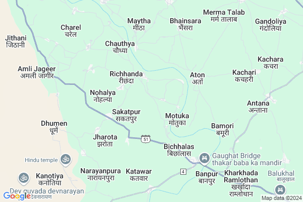
Amli Khalsa Map
EDIT Map
Add Your House
 ..
..
Current Corona Virus Infected Patients Count in Baran District
| City Name | District Name | Total Covid cases |
|---|
Locality Name :
Amli Khalsa
( अमली खालसा )
Tehsil Name : Atru
District : Baran
State : Rajasthan
Division : Kota
Language : Hindi and Rajasthani
Current Time 10:49 AM
Date: Saturday , Apr 26,2025 (IST)
Time zone: IST (UTC+5:30)
Elevation / Altitude: 289 meters. Above Seal level
Telephone Code / Std Code: 07451
Assembly constituency : Sangod assembly constituency
Assembly MLA : Heeralal Nagar
Lok Sabha constituency : Kota parliamentary constituency
Parliament MP : OM BIRLA
Serpanch Name :
Pin Code : 325223
Post Office Name : Atone
Main Village Name : Amli Khalsa
Commodities Prices : Atru Market / Mandi
Rivers Near Amli Khalsa
Ahu
Garni Nadi
Ahu
Garni Nadi
About Amli Khalsa
Correct below Info and add more info about Amli KhalsaAmli Khalsa is a small Village/hamlet in Atru Tehsil in Baran District of Rajasthan State, India. It comes under Amli Khalsa Panchayath. It belongs to Kota Division . It is located 33 KM towards South from District head quarters Baran. 7 KM from Atru. 283 KM from State capital Jaipur
Amli Khalsa Pin code is 325223 and postal head office is Atone .
Bamori ( 4 KM ) , Katawar ( 5 KM ) , Bhainsara ( 6 KM ) , Antana ( 8 KM ) , Kharkhada Ramlothan ( 9 KM ) are the nearby Villages to Amli Khalsa. Amli Khalsa is surrounded by Khanpur Tehsil towards west , Baran (Full) Tehsil towards North , Chhipabarod Tehsil towards South , Sangod Tehsil towards west .
Baran , Jhalawar , Mangrol , Ramganj Mandi are the near by Cities to Amli Khalsa.
Amli Khalsa 2011 Census Details
Amli Khalsa Local Language is Hindi. Amli Khalsa Village Total population is 706 and number of houses are 141. Female Population is 48.4%. Village literacy rate is 59.8% and the Female Literacy rate is 21.0%.
Population
| Census Parameter | Census Data |
| Total Population | 706 |
| Total No of Houses | 141 |
| Female Population % | 48.4 % ( 342) |
| Total Literacy rate % | 59.8 % ( 422) |
| Female Literacy rate | 21.0 % ( 148) |
| Scheduled Tribes Population % | 0.0 % ( 0) |
| Scheduled Caste Population % | 30.9 % ( 218) |
| Working Population % | 55.1 % |
| Child(0 -6) Population by 2011 | 85 |
| Girl Child(0 -6) Population % by 2011 | 54.1 % ( 46) |
Amli Khalsa Census More Deatils.
Politics in Amli Khalsa
RRP , BJP , INC are the major political parties in this area.Polling Stations /Booths near Amli Khalsa
1)Govt. Upper Primary School Room No. 1 Haripura2)Govt. Upper Primary School Room No. 1 Bapawar Khurd
3)Govt. Primary School Room No. 1 Gopalpura
4)Govt. Upper Primary School Room No. 2 Sangod
5)Govt. Secondary School Room No. 1 Kurariya Khurd
HOW TO REACH Amli Khalsa
By Rail
There is no railway station near to Amli Khalsa in less than 10 km.Colleges near Amli Khalsa
Glg College Of Computer Education
Address :
Mahtma Gopal Ram Mahavidhalya
Address :
Svcttr
Address :
Swami Vivekananda College Of Teachers Training & Research
Address : Khandela Road Danta
Government Girls College Of Baran
Address : Hospital Road, Baran - 325205
Schools in Amli Khalsa
G.u.p.s. Amlikhalsa
Address : amli khalsa , atru , baran , Rajasthan . PIN- 325223 , Post - Atone
Govt Health Centers near Amli Khalsa
1) Kherliganj , ANM House , Khedliganj , Near CHC Atru2) Gordi , Sub Health Centar Gordi , Gordi , Gordi
3) Jalwara , Jalwara , Baran Road Jalwara ,
Sub Villages in Amli Khalsa
Hospitals in Amli Khalsa,Atru
Up Swasthya Kendra
Amli; Baran; SH-37A; Baran; Baran; Rajasthan 325210; India
14.6 KM distance Detail
more ..
Petrol Bunks in Amli Khalsa,Atru
HP PETROL PUMP - KANHA FILLING STATION
Village Atru Tehsil Atru; NH 12; Kota; Rajasthan 325219; India
15.6 KM distance Detail
more ..
Colleges in Amli Khalsa,Atru
Shree Shyam Pvt ITI
keshav Vihar Colony; Bus Stand Road; Atru; District Baran; Atru; Rajasthan 325218; India
15.8 KM distance Detail
Keshave college
Rajasthan State Highway 37A; Govindpura; Rajasthan 325218; India
16.8 KM distance Detail
more ..
Schools in Amli Khalsa,Atru
सर्वोदय माध्यमिक बाल विद्या मन्दिर रीच्छन्दा
Deoli Rawan; Rajasthan 325223; India
2.0 KM distance Detail
Super Markets in Amli Khalsa,Atru
Seema Provijan Store Atru
Railway Station; Atru;; Atru; Rajasthan 325218; India
16.3 KM distance Detail
Governement Offices near Amli Khalsa,Atru
Atal Seva Kendra
Mermachah; Baran; SH-37A; Baran; Baran; Rajasthan 325218; India
14.4 KM distance Detail
About Amli Khalsa &
History
How to reach Amli Khalsa
Tourist Places Near By Amli Khalsa
Schools in Amli Khalsa
Colleges in Amli Khalsa
Temperature & weather of Amli Khalsa
places in Amli Khalsa
Amli Khalsa photos
More Information
How to reach Amli Khalsa
Tourist Places Near By Amli Khalsa
Schools in Amli Khalsa
Colleges in Amli Khalsa
Temperature & weather of Amli Khalsa
places in Amli Khalsa
Amli Khalsa photos
More Information
Village Talk
Post News or Events about this Village
Near Cities
Baran 31 KM near
Jhalawar 53 KM near
Mangrol 61 KM near
Ramganj Mandi 72 KM near
Baran 31 KM near
Jhalawar 53 KM near
Mangrol 61 KM near
Ramganj Mandi 72 KM near
Near By Taluks
Atru 7 KM near
Khanpur 29 KM near
Baran (Full) 30 KM near
Chhipabarod 37 KM near
Atru 7 KM near
Khanpur 29 KM near
Baran (Full) 30 KM near
Chhipabarod 37 KM near
Near By Air Ports
Bhopal Airport 214 KM near
Sanganeer Airport 260 KM near
Gwalior Airport 262 KM near
Indore Airport 275 KM near
Bhopal Airport 214 KM near
Sanganeer Airport 260 KM near
Gwalior Airport 262 KM near
Indore Airport 275 KM near
Near By Tourist Places
Jhalawar 77 KM near
Kota 89 KM near
Guna 90 KM near
Bundi 126 KM near
Bijolia 142 KM near
Jhalawar 77 KM near
Kota 89 KM near
Guna 90 KM near
Bundi 126 KM near
Bijolia 142 KM near
Near By Districts
Baran 31 KM near
Jhalawar 52 KM near
Kota 87 KM near
Guna 90 KM near
Baran 31 KM near
Jhalawar 52 KM near
Kota 87 KM near
Guna 90 KM near
Near By RailWay Station
Baran Rail Way Station 31 KM near
Chhabra Gugor Rail Way Station 39 KM near
Baran Rail Way Station 31 KM near
Chhabra Gugor Rail Way Station 39 KM near