| Home | City Bus | Maps | Villages | Cities | Rail | Tourist Places | School | College | Pin Codes | Corona Cases Count |
| Distance Calculator Bus Services IFSC Codes Trace Mobile Number Weather Search Place Trace IP Available Cash ATM/Banks Locate Polling Booth Report an Error contact People |
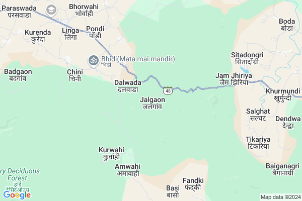
Jalgaon
Jalgaon Map
EDIT Map
Add Your House
 ..
..
Current Corona Virus Infected Patients Count in Balaghat District
| City Name | District Name | Total Covid cases |
|---|
Locality Name :
Jalgaon
( जलगाओं )
Tehsil Name : Paraswada
District : Balaghat
State : Madhya Pradesh
Division : Jabalpur
Language : Hindi and Marathi
Current Time 11:26 AM
Date: Sunday , Apr 27,2025 (IST)
Time zone: IST (UTC+5:30)
Telephone Code / Std Code: 07634
Assembly constituency : Paraswada assembly constituency
Assembly MLA : Madhu Bhau Bhagat
Lok Sabha constituency : Balaghat parliamentary constituency
Parliament MP : DR DHAL SINGH BISEN
Serpanch Name :
Pin Code : 481556
Post Office Name : Paraswada
Main Village Name : Jalgaon
Commodities Prices : Praswada Market / Mandi
Rivers Near Jalgaon
Hirri
Poldah
Hirri
Poldah
About Jalgaon
Correct below Info and add more info about JalgaonJalgaon is a small Village/hamlet in Paraswada Tehsil in Balaghat District of Madhya Pradesh State, India. It comes under Jalgaon Panchayath. It belongs to Jabalpur Division . It is located 46 KM towards North from District head quarters Balaghat. 8 KM from Paraswada. 387 KM from State capital Bhopal
Jalgaon Pin code is 481556 and postal head office is Paraswada .
Sitadongri ( 8 KM ) , Pondi ( 8 KM ) , Linga ( 8 KM ) , Pongarjhodi ( 8 KM ) , Tikariya ( 9 KM ) are the nearby Villages to Jalgaon. Jalgaon is surrounded by Baihar Tehsil towards East , Balaghat Tehsil towards South , Birsa Tehsil towards East , Lalbarra Tehsil towards west .
Malajkhand , Balaghat , Nainpur , Wara Seoni are the near by Cities to Jalgaon.
Jalgaon 2011 Census Details
Jalgaon Local Language is Hindi. Jalgaon Village Total population is 267 and number of houses are 63. Female Population is 49.4%. Village literacy rate is 43.4% and the Female Literacy rate is 17.6%.
Population
| Census Parameter | Census Data |
| Total Population | 267 |
| Total No of Houses | 63 |
| Female Population % | 49.4 % ( 132) |
| Total Literacy rate % | 43.4 % ( 116) |
| Female Literacy rate | 17.6 % ( 47) |
| Scheduled Tribes Population % | 99.3 % ( 265) |
| Scheduled Caste Population % | 0.0 % ( 0) |
| Working Population % | 56.9 % |
| Child(0 -6) Population by 2011 | 42 |
| Girl Child(0 -6) Population % by 2011 | 52.4 % ( 22) |
Jalgaon Census More Deatils.
Politics in Jalgaon
Bharatiya Janata Party , BJP , INC are the major political parties in this area.Polling Stations /Booths near Jalgaon
1)Duglai2)Bagholi-1
3)Dahigadva
4)Mohgaon
5)Khalondi
HOW TO REACH Jalgaon
By Rail
There is no railway station near to Jalgaon in less than 10 km.Colleges near Jalgaon
Govt Art And Commerce College Katangi
Address :
Om Politechnic College, Manegaon
Address :
Govt.college Kirnapur
Address :
Mt. Sm Deo Homoeopathic & Biochemic Medical College & Hospital, Balaghat, Madhya Pradesh
Address : Dev Nagarikhursodi, Gondia Road
Schools in Jalgaon
Ps Jal Gaon
Address : jalgaon , paraswada , balaghat , Madhya Pradesh . PIN- 481556 , Post - Paraswada
Govt Health Centers near Jalgaon
1) SHC Bagholi , Sub Health Centre , JALGAON ROAD BAGHOLI , BAJAR CHOUK BAGHOLI2) SHC Chini , Sub Health Centre , WARD NO. 01 CHINI , BHIDI ROAD CHINI
3) SHC Sitadongri , Sub Health Centre , ,
Sub Villages in Jalgaon
Hospitals in Jalgaon,Paraswada
Chirayu Health Care Centre Paraswada
Baihar Lamta Rd; Paraswada; Madhya Pradesh 481556; India
12.5 KM distance Detail
Govt Homoeopathic Dispensary
518/1-kh/4; Madhya Pradesh State Highway 26; Baihar; Madhya Pradesh 481111; India
19.1 KM distance Detail
Govt Ayurvedic Hospital Baihar
518/1-kh/4; Madhya Pradesh State Highway 26; Baihar; Madhya Pradesh 481111; India
19.2 KM distance Detail
more ..
Petrol Bunks in Jalgaon,Paraswada
HP PETROL PUMP - DIVYA PETROLEUM
Lamta-baihar Road AT -paraswada Tehsil-baihar; Madhya Pradesh 481556; India
11.8 KM distance Detail
Bhatia Petrol Pump
518/1-kh/4; MP SH 26; Baihar; Madhya Pradesh 481111; India
19.5 KM distance Detail
HP PETROL PUMP - SHRI MARUTI BAIHAR
HPC Petrol Pump Village Baihar Tehsil Baihar; Jabalpur; Madhya Pradesh 481111; India
19.5 KM distance Detail
more ..
Colleges in Jalgaon,Paraswada
Government Degree College; Paraswada
At-Linga Paraswada; Balaghat; Madhya Pradesh 481556; India
13.3 KM distance Detail
more ..
Schools in Jalgaon,Paraswada
Kamlesh Memorial School
Baihar Lamta Rd; Paraswada; Madhya Pradesh 481556; India
12.7 KM distance Detail
Progressive Convent English School Paraswada
Paraswada; Madhya Pradesh 481556; India
12.9 KM distance Detail
Super Markets in Jalgaon,Paraswada
Sanjay Kirana
518/1-kh/4; Madhya Pradesh State Highway 26; Baihar; Madhya Pradesh 481111; India
19.4 KM distance Detail
Police Stations near Jalgaon,Paraswada
Baihar Police Station
518/1-kh/4; MP SH 26; Baihar; Madhya Pradesh 481111; India
19.3 KM distance Detail
About Jalgaon &
History
How to reach Jalgaon
Tourist Places Near By Jalgaon
Schools in Jalgaon
Colleges in Jalgaon
Temperature & weather of Jalgaon
places in Jalgaon
Jalgaon photos
More Information
How to reach Jalgaon
Tourist Places Near By Jalgaon
Schools in Jalgaon
Colleges in Jalgaon
Temperature & weather of Jalgaon
places in Jalgaon
Jalgaon photos
More Information
Village Talk
Post News or Events about this Village
Near Cities
Malajkhand 39 KM near
Balaghat 43 KM near
Nainpur 50 KM near
Wara Seoni 59 KM near
Malajkhand 39 KM near
Balaghat 43 KM near
Nainpur 50 KM near
Wara Seoni 59 KM near
Near By Taluks
Paraswada 7 KM near
Baihar 25 KM near
Balaghat 38 KM near
Birsa 46 KM near
Paraswada 7 KM near
Baihar 25 KM near
Balaghat 38 KM near
Birsa 46 KM near
Near By Air Ports
Jabalpur Airport 86 KM near
Raipur Airport 194 KM near
Sonegaon Airport 200 KM near
Khajuraho Airport 340 KM near
Jabalpur Airport 86 KM near
Raipur Airport 194 KM near
Sonegaon Airport 200 KM near
Khajuraho Airport 340 KM near
Near By Tourist Places
Kanha National park 33 KM near
Pench National Park 92 KM near
Seoni 97 KM near
Kawardha 98 KM near
Jabalpur 139 KM near
Kanha National park 33 KM near
Pench National Park 92 KM near
Seoni 97 KM near
Kawardha 98 KM near
Jabalpur 139 KM near
Near By Districts
Balaghat 44 KM near
Mandla 59 KM near
Gondia 85 KM near
Seoni 97 KM near
Balaghat 44 KM near
Mandla 59 KM near
Gondia 85 KM near
Seoni 97 KM near
Near By RailWay Station
Gondia Junction Rail Way Station 85 KM near
Amgaon Rail Way Station 94 KM near
Gondia Junction Rail Way Station 85 KM near
Amgaon Rail Way Station 94 KM near