| Home | City Bus | Maps | Villages | Cities | Rail | Tourist Places | School | College | Pin Codes | Corona Cases Count |
| Distance Calculator Bus Services IFSC Codes Trace Mobile Number Weather Search Place Trace IP Available Cash ATM/Banks Locate Polling Booth Report an Error contact People |
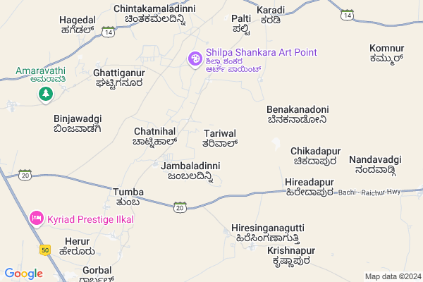
Tariwal Map
EDIT Map
Add Your House
 ..
..
Current Corona Virus Infected Patients Count in Bagalkot District
| City Name | District Name | Total Covid cases |
|---|---|---|
| Bagalkote District | Bagalkote | 13 |
| Mudhol | Bagalkote | 8 |
| Jamakhandi | Bagalkote | 2 |
| Jamkhandi | Bagalkote | 1 |
Locality Name :
Tariwal
( ತರಿವಾಲ್ )
Taluk Name : Hungund
District : Bagalkot
State : Karnataka
Division : Belgaum
Language : Kannada and Konkani, Telugu, English
Current Time 02:58 PM
Date: Tuesday , Apr 29,2025 (IST)
Time zone: IST (UTC+5:30)
Elevation / Altitude: 508 meters. Above Seal level
Telephone Code / Std Code: 08351
Assembly constituency : Hungund assembly constituency
Assembly MLA : Kashappanavara Vijayanand Shivashankrappa
Lok Sabha constituency : Bagalkot parliamentary constituency
Parliament MP : Gaddigoudar Parvatagouda Chandanagouda
Serpanch Name :
Pin Code : 587125
Post Office Name : Ilkal
Main Village Name : Tariwal
Commodities Prices : Kustagi Market / Mandi
National Highways Reachable To Tariwal
Nationa High Way :NH50
Nationa High Way :NH367
Nationa High Way :NH50
Nationa High Way :NH367
Rivers Near Tariwal
Malaprabha :ಮಲಪ್ರಭಾ
Malaprabha :ಮಲಪ್ರಭಾ
Malaprabha :ಮಲಪ್ರಭಾ
Malaprabha :ಮಲಪ್ರಭಾ
About Tariwal
Correct below Info and add more info about TariwalTariwal is a small Village/hamlet in Hungund Taluk in Bagalkot District of Karnataka State, India. It comes under Tariwal Panchayath. It belongs to Belgaum Division . It is located 65 KM towards East from District head quarters Bagalkot. 15 KM from Hungund. 437 KM from State capital Bangalore
Tariwal Pin code is 587125 and postal head office is Ilkal .
Gorabal ( 11 KM ) , Nandwadgi ( 12 KM ) , Amarawati ( 13 KM ) , Hungund ( 15 KM ) are the nearby Villages to Tariwal. Tariwal is surrounded by Kushtagi Taluk towards South , Muddebihal Taluk towards North , Lingsugur Taluk towards East , Bagalkot Taluk towards west .
Lingsugur , Muddebihal , Talikota , Ron are the near by Cities to Tariwal.
Tariwal 2011 Census Details
Tariwal Local Language is Kannada. Tariwal Village Total population is 683 and number of houses are 123. Female Population is 50.8%. Village literacy rate is 68.5% and the Female Literacy rate is 29.0%.
Population
| Census Parameter | Census Data |
| Total Population | 683 |
| Total No of Houses | 123 |
| Female Population % | 50.8 % ( 347) |
| Total Literacy rate % | 68.5 % ( 468) |
| Female Literacy rate | 29.0 % ( 198) |
| Scheduled Tribes Population % | 7.5 % ( 51) |
| Scheduled Caste Population % | 22.4 % ( 153) |
| Working Population % | 43.2 % |
| Child(0 -6) Population by 2011 | 95 |
| Girl Child(0 -6) Population % by 2011 | 44.2 % ( 42) |
Tariwal Census More Deatils.
Politics in Tariwal
JD(U) , Bharatiya Janata Party , BJP , Bharatiya Janata Party (BJP) , INC are the major political parties in this area.Polling Stations /Booths near Tariwal
1)Govt Kannada Boys And Girls School Pochapur2)Kannada Boys School Balakundi (south Side)
3)Kannada Boys School Nidasanur
4)Govt Higher Primary School Bisaladinni (shouth Side)
5)Kannada Boys School Sankalapur
HOW TO REACH Tariwal
By Road
Hungund is the Nearest Town to Tariwal. Hungund is 9 km from Tariwal. Road connectivity is there from Hungund to Tariwal.By Rail
There is no railway station near to Tariwal in less than 10 km.Colleges near Tariwal
Govt Pu College Hungund
Address :
S C P U College Amingad
Address :
Rudragonda Patil Govt. First Grade College
Address : Dist.:bijapur Karnataka
S.r.kanthi College Of Education
Address : S.r.kanthi College Of Education Ilkal Bagalkot5871
Schools in Tariwal
Govt Kblps Tariwal
Address : tariwal , hunagund , bagalkot , Karnataka . PIN- 587125 , Post - Ilkal
Govt Health Centers near Tariwal
1) Nalatwad CHC , Government Hospital Nalatwad , CHC Nalatwad , Main road Nalatwad2) Tavargera-A , Sub Centre Tavargera A , Mudagal Road ,
3) FRU Kushtagi Taluka Hospital , , ,
Sub Villages in Tariwal
Petrol Bunks in Tariwal,Hungund
Gurunanak Fuels Hindustan Petroleum
Bagalkot; NH-13; Solapur Mangalore Highway; Ilkal; Ilkal; Karnataka 587154; India
12.8 KM distance Detail
HP PETROL PUMP - GURU MAHANT PETROLEUMS
HPC Dealers Taluka Hungund; Ilkal; Belgaum; Karnataka 587125; India
12.8 KM distance Detail
MAHANT PETROLEUM
ILKAL TOWN;ILKAL;BAGALKOT; BAGALKOT; Karnataka 587125; India
13.0 KM distance Detail
Bharath Petrolium
Bagalkot; NH-13; Solapur Mangalore Highway; Ilkal; Ilkal; Karnataka 587125; India
13.0 KM distance Detail
more ..
Colleges in Tariwal,Hungund
Government PU College
Bagalkot; NH-13; Solapur Mangalore Highway; Ilkal; Ilkal; Karnataka 587154; India
12.5 KM distance Detail
more ..
Governement Offices near Tariwal,Hungund
City Municipal Corporation
Bagalkot District; Ilkal; Karnataka 587125; India
13.2 KM distance Detail
About Tariwal &
History
How to reach Tariwal
Tourist Places Near By Tariwal
Schools in Tariwal
Colleges in Tariwal
Temperature & weather of Tariwal
places in Tariwal
Tariwal photos
More Information
How to reach Tariwal
Tourist Places Near By Tariwal
Schools in Tariwal
Colleges in Tariwal
Temperature & weather of Tariwal
places in Tariwal
Tariwal photos
More Information
Village Talk
Post News or Events about this Village
Near Cities
Lingsugur 36 KM near
Muddebihal 37 KM near
Talikota 57 KM near
Ron 68 KM near
Lingsugur 36 KM near
Muddebihal 37 KM near
Talikota 57 KM near
Ron 68 KM near
Near By Taluks
Hungund 14 KM near
Kushtagi 26 KM near
Muddebihal 36 KM near
Lingsugur 41 KM near
Hungund 14 KM near
Kushtagi 26 KM near
Muddebihal 36 KM near
Lingsugur 41 KM near
Near By Air Ports
Hubli Airport 156 KM near
Sambre Airport 188 KM near
Sholapur Airport 200 KM near
Kolhapur Airport 234 KM near
Hubli Airport 156 KM near
Sambre Airport 188 KM near
Sholapur Airport 200 KM near
Kolhapur Airport 234 KM near
Near By Tourist Places
Aihole 35 KM near
Pattadakkal 45 KM near
Badami 62 KM near
Hampi 94 KM near
Hospet 98 KM near
Aihole 35 KM near
Pattadakkal 45 KM near
Badami 62 KM near
Hampi 94 KM near
Hospet 98 KM near
Near By Districts
Bagalkot 62 KM near
Koppal 87 KM near
Gadag 100 KM near
Bijapur District 112 KM near
Bagalkot 62 KM near
Koppal 87 KM near
Gadag 100 KM near
Bijapur District 112 KM near
Near By RailWay Station
Almatti Rail Way Station 50 KM near
Bagalkot Junction Rail Way Station 59 KM near
Almatti Rail Way Station 50 KM near
Bagalkot Junction Rail Way Station 59 KM near