| Home | City Bus | Maps | Villages | Cities | Rail | Tourist Places | School | College | Pin Codes | Corona Cases Count |
| Distance Calculator Bus Services IFSC Codes Trace Mobile Number Weather Search Place Trace IP Available Cash ATM/Banks Locate Polling Booth Report an Error contact People |
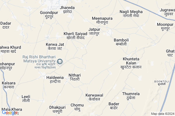
Naithla Map
EDIT Map
Add Your House
 ..
..
Current Corona Virus Infected Patients Count in Alwar District
| City Name | District Name | Total Covid cases |
|---|---|---|
| Alwar District | Alwar | 7 |
Locality Name :
Naithla
( नैथला )
Tehsil Name : Umren
District : Alwar
State : Rajasthan
Division : Jaipur
Language : Rajasthani
Current Time 01:48 PM
Date: Monday , Apr 28,2025 (IST)
Time zone: IST (UTC+5:30)
Elevation / Altitude: 264 meters. Above Seal level
Telephone Code / Std Code: 0144
Assembly constituency : Alwar Rural assembly constituency
Assembly MLA : Tikaram Jully
Lok Sabha constituency : Bharatpur parliamentary constituency
Parliament MP : RANJEETA KOLI
Serpanch Name :
Pin Code : 301021
Post Office Name : Barodameo
Main Village Name : Naithla
Commodities Prices : Khedh(Bodaramev) Market / Mandi
National Highways Reachable To Naithla
Nationa High Way :NH248A
Nationa High Way :NH48
Nationa High Way :NH248A
Nationa High Way :NH48
Rivers Near Naithla
Sahibi
Sahibi
About Naithla
Correct below Info and add more info about NaithlaNaithla is a small Village/hamlet in Umren Tehsil in Alwar District of Rajasthan State, India. It comes under Naithla Panchayath. It belongs to Jaipur Division . It is located 20 KM towards South from District head quarters Alwar. 13 KM from Umren. 125 KM from State capital Jaipur
Naithla Pin code is 301021 and postal head office is Barodameo .
Khuteta Kala ( 5 KM ) , Haldina ( 6 KM ) , Bader ( 8 KM ) , Salpur ( 8 KM ) , Bhajeet ( 9 KM ) are the nearby Villages to Naithla. Naithla is surrounded by Alwar Tehsil towards North , Lachhmangarh Tehsil towards East , Ramgarh Tehsil towards North , Reni Tehsil towards South .
Alwar , Rajgarh (Alwar) , Nagar , Bandikui are the near by Cities to Naithla.
Naithla 2011 Census Details
Naithla Local Language is Rajasthani. Naithla Village Total population is 2688 and number of houses are 482. Female Population is 46.3%. Village literacy rate is 52.9% and the Female Literacy rate is 17.6%.
Population
| Census Parameter | Census Data |
| Total Population | 2688 |
| Total No of Houses | 482 |
| Female Population % | 46.3 % ( 1244) |
| Total Literacy rate % | 52.9 % ( 1421) |
| Female Literacy rate | 17.6 % ( 474) |
| Scheduled Tribes Population % | 28.7 % ( 772) |
| Scheduled Caste Population % | 13.7 % ( 368) |
| Working Population % | 43.7 % |
| Child(0 -6) Population by 2011 | 481 |
| Girl Child(0 -6) Population % by 2011 | 45.9 % ( 221) |
Naithla Census More Deatils.
Politics in Naithla
Bharatiya Janata Party , BJP , INC are the major political parties in this area.Polling Stations /Booths near Naithla
1)Baba Sardara Ram Senior Secondary School Shahpur2)Govt. Secondary School West Side Keethur
3)Govt. Secondary School North Side Dhakpuri
4)Govt. Secondary School South Side Dhakpuri
5)Govt. Secondary School West Side Jatiyana
HOW TO REACH Naithla
By Rail
There is no railway station near to Naithla in less than 10 km.Colleges near Naithla
Govt. Polytechnic College, Neemrana (rajasthan)
Address :
Bhagat Singh Mahila College Kotkasim
Address :
Anibesaint Girls College
Address :
Govt Bibirani College, Bibirani, Kotkasim
Address :
Janki Devi College Thanagazi
Address : Pratapagarh Road Thanagazi
Schools near Naithla
Govt.ss. Dhakpuri
Address : dhakpuri , umerain , alwar , Rajasthan . PIN- 301001 , Post - Alwar
Adrsh Vivekanand Ups Akbarpur
Address : akbarpur , umerain , alwar , Rajasthan . PIN- 301001 , Post - Alwar
Arti Public Ups
Address : akbarpur , umerain , alwar , Rajasthan . PIN- 301001 , Post - Alwar
Hari Singh Akbarpur
Address : akbarpur , umerain , alwar , Rajasthan . PIN- 301031
Govt Health Centers near Naithla
1) Pali , pali , ,2) Malikhera , , ,
3) Chilodi , chilodi , ,
Sub Villages in Naithla
Hospitals in Naithla,Umren
Hamid Medical And Dental Hospital..Dr Pankaj Meena
Sayed kherli near; Kakrali Jat; Rajasthan; India
4.3 KM distance Detail
more ..
Petrol Bunks in Naithla,Umren
HP PETROL PUMP - CHOUDHARY FILLING STATION
Village Bambolli;bagad Rajput Near Bagad KA Tiraha SH-14; Rajasthan 301001; India
9.1 KM distance Detail
HP PETROL PUMP - HP BG FILLING STATION
H1-494; Matasya Industrial Area TIN-08890607574; Jaipur; Rajasthan 321607; India
9.2 KM distance Detail
more ..
Colleges in Naithla,Umren
Siddhi Vinayak Online Exam Center
Matsya Industrial Area; Desoola; Rajasthan 301030; India
10.5 KM distance Detail
Siddhi Vinayak online Examination Center
M.I.A; Matsya Industrial Area; Alwar; Rajasthan 301030; India
10.5 KM distance Detail
Siddhi Vinayak Group of Institutes
E1; B1 MIA; Matsya Industrial Area; Alwar; Rajasthan 301030; India
10.5 KM distance Detail
more ..
Police Stations near Naithla,Umren
RAC Police Training Center
Alwar - Bharatpur Rd; Bagar Meo; Rajasthan 301021; India
9.2 KM distance Detail
Governement Offices near Naithla,Umren
Supereme Internet U P Behti Form
RJ SH 14; Bagar Meo; Rajasthan 301021; India
10.3 KM distance Detail
About Naithla &
History
How to reach Naithla
Tourist Places Near By Naithla
Schools in Naithla
Colleges in Naithla
Temperature & weather of Naithla
places in Naithla
Naithla photos
More Information
How to reach Naithla
Tourist Places Near By Naithla
Schools in Naithla
Colleges in Naithla
Temperature & weather of Naithla
places in Naithla
Naithla photos
More Information
Village Talk
Post News or Events about this Village
Near Cities
Alwar 19 KM near
Rajgarh (Alwar) 28 KM near
Nagar 42 KM near
Bandikui 53 KM near
Alwar 19 KM near
Rajgarh (Alwar) 28 KM near
Nagar 42 KM near
Bandikui 53 KM near
Near By Taluks
Umren 13 KM near
Lachhmangarh 17 KM near
Alwar 17 KM near
Ramgarh 19 KM near
Umren 13 KM near
Lachhmangarh 17 KM near
Alwar 17 KM near
Ramgarh 19 KM near
Near By Air Ports
Sanganeer Airport 128 KM near
Kheria Airport 142 KM near
Indira Gandhi International Airport 144 KM near
Gwalior Airport 221 KM near
Sanganeer Airport 128 KM near
Kheria Airport 142 KM near
Indira Gandhi International Airport 144 KM near
Gwalior Airport 221 KM near
Near By Tourist Places
Alwar 18 KM near
Sariska 38 KM near
Kalakho 71 KM near
Govardhan 82 KM near
Nuh 87 KM near
Alwar 18 KM near
Sariska 38 KM near
Kalakho 71 KM near
Govardhan 82 KM near
Nuh 87 KM near
Near By Districts
Alwar 19 KM near
Dausa 83 KM near
Mewat 86 KM near
Bharatpur 90 KM near
Alwar 19 KM near
Dausa 83 KM near
Mewat 86 KM near
Bharatpur 90 KM near
Near By RailWay Station
Alwar Junction Rail Way Station 17 KM near
Rajgarh Rail Way Station 28 KM near
Alwar Junction Rail Way Station 17 KM near
Rajgarh Rail Way Station 28 KM near