| Home | City Bus | Maps | Villages | Cities | Rail | Tourist Places | School | College | Pin Codes | Corona Cases Count |
| Distance Calculator Bus Services IFSC Codes Trace Mobile Number Weather Search Place Trace IP Available Cash ATM/Banks Locate Polling Booth Report an Error contact People |
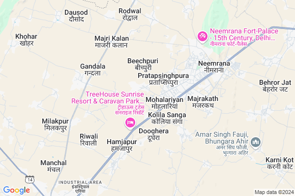
Fatehpura Map
EDIT Map
Add Your House
 ..
..
Current Corona Virus Infected Patients Count in Alwar District
| City Name | District Name | Total Covid cases |
|---|---|---|
| Alwar District | Alwar | 7 |
Locality Name :
Fatehpura
( फतेहपुरा )
Tehsil Name : Nimrana
District : Alwar
State : Rajasthan
Division : Jaipur
Language : Rajasthani
Current Time 11:20 PM
Date: Friday , Apr 25,2025 (IST)
Time zone: IST (UTC+5:30)
Elevation / Altitude: 273 meters. Above Seal level
Telephone Code / Std Code: 01494
Assembly constituency : Mundawar assembly constituency
Assembly MLA : Lalit Yadav
Lok Sabha constituency : Alwar parliamentary constituency
Parliament MP : Balak Nath
Serpanch Name :
Pin Code : 301709
Post Office Name : Gandala
Main Village Name : Fatehpura
Commodities Prices : Mohindergarh Market / Mandi
National Highways Reachable To Fatehpura
Nationa High Way :NH148B
Nationa High Way :NH48
Nationa High Way :NH148B
Nationa High Way :NH48
Rivers Near Fatehpura
Chalak Nala
Chalak Nala
About Fatehpura
Correct below Info and add more info about FatehpuraFatehpura is a small Village/hamlet in Nimrana Tehsil in Alwar District of Rajasthan State, India. It comes under Fatehpura Panchayath. It belongs to Jaipur Division . It is located 58 KM towards North from District head quarters Alwar. 9 KM from Neemrana. 149 KM from State capital Jaipur
Fatehpura Pin code is 301709 and postal head office is Gandala .
Kolila Joga ( 4 KM ) , Gandala ( 4 KM ) , Neemrana ( 4 KM ) , Majri Kalan ( 5 KM ) , Rewali ( 6 KM ) are the nearby Villages to Fatehpura. Fatehpura is surrounded by Behror Tehsil towards west , Mandawar Tehsil towards East , Ateli Nangal Tehsil towards North , Nangal Chaudhry Tehsil towards west .
Narnaul , Bawal , Rewari , Mahendragarh are the near by Cities to Fatehpura.
This Place is in the border of the Alwar District and Mahendragarh District. Mahendragarh District Ateli Nangal is North towards this place . It is near to the Haryana State Border.
Fatehpura 2011 Census Details
Fatehpura Local Language is Rajasthani. Fatehpura Village Total population is 709 and number of houses are 121. Female Population is 49.2%. Village literacy rate is 60.9% and the Female Literacy rate is 23.0%.
Population
| Census Parameter | Census Data |
| Total Population | 709 |
| Total No of Houses | 121 |
| Female Population % | 49.2 % ( 349) |
| Total Literacy rate % | 60.9 % ( 432) |
| Female Literacy rate | 23.0 % ( 163) |
| Scheduled Tribes Population % | 0.0 % ( 0) |
| Scheduled Caste Population % | 56.6 % ( 401) |
| Working Population % | 54.2 % |
| Child(0 -6) Population by 2011 | 103 |
| Girl Child(0 -6) Population % by 2011 | 48.5 % ( 50) |
Fatehpura Census More Deatils.
Politics in Fatehpura
Bharatiya Janata Party , BJP , INC are the major political parties in this area.Polling Stations /Booths near Fatehpura
1)Government Secondaryondary School Salarpur (north Part)2)Government Secondaryondary School Palawa (room No. 6)
3)Government Secondaryondary School Dantala (room No.-10)
4)Government Upper Primary Janaksinghpura
5)Government Upper Primary Madhosinghpura
HOW TO REACH Fatehpura
By Rail
There is no railway station near to Fatehpura in less than 10 km.Colleges near Fatehpura
Govt. Polytechnic College, Neemrana (rajasthan)
Address :
Shahajhanpur P.g College
Address :
Srsm Educon Services
Address :
Govt Polytechnic College
Address :
Govt Polytechnic College
Address :
Schools near Fatehpura
Sidharth Pub. Sch. Doomroli
Address : doomroli , neemrana , alwar , Rajasthan . PIN- 301703 , Post - Majari Kalan
Rao Jaidyal Pub. Majari Kalan
Address : majri kalan , neemrana , alwar , Rajasthan . PIN- 301703 , Post - Majari Kalan
Baba Khmdas School Rayasarana
Address : raysarana , neemrana , alwar , Rajasthan . PIN- 301708 , Post - Kutina
Jagdamba Acadmy Mandhan
Address : mandan , neemrana , alwar , Rajasthan . PIN- 301704 , Post - Mandhan
Govt Health Centers near Fatehpura
1) Dhundhariya , SUBCENTER , ,2) Basai , SUBCENTER , ,
3) Gandala , PRIMARY HEALTH CENTER , ,
Sub Villages in Fatehpura
Hospitals in Fatehpura,Nimrana
Sachkhand Hospital And Troma Centre (सचखंड अस्पताल)
Neemrana; Rajasthan 301709; India
3.6 KM distance Detail
Sachkhand Hospital
G-129; Phase -2; Delhi - Jaipur Expressway; Near Hanuman Mandir; Neemrana; Rajasthan 301705; India
3.6 KM distance Detail
more ..
Petrol Bunks in Fatehpura,Nimrana
Shahid Narendra Kumar Filling Station
Neemrana; Alwar; NH-8; Neemrana Road; Behror; Behror; Rajasthan 301020; India
3.6 KM distance Detail
Patrol Pump
Near Sr. Sec. School; Kund - Majari - Behror Rd; Gandala; Rajasthan 301709; India
5.4 KM distance Detail
more ..
Colleges in Fatehpura,Nimrana
Goverment Polotechnic College ; Daulatsinghpura Asd
Daulatsinghpura; Rajasthan 301709; India
4.6 KM distance Detail
more ..
Schools in Fatehpura,Nimrana
Tagore Public School Bichpuri ; Neemrana
Dhoondhariya; Rajasthan 301709; India
0.8 KM distance Detail
Shivani Secondary School;bichpuri;neemrana
; Parana Patti; Beechpuri; Rajasthan 301709; India
0.9 KM distance Detail
Satya Bharti Government School Fatehpura
Delhi - Jaipur Expy; Dhoondhariya; Rajasthan 301709; India
1.0 KM distance Detail
Super Markets in Fatehpura,Nimrana
Shiv Annapurna Kiryana Store
shop no G-134;shree Ram Plaza; Neemrana; Rajasthan; India
5.3 KM distance Detail
Local Parks in Fatehpura,Nimrana
TSSR Forest
TS Tech Sun Rajasthan Pvt. Ltd.; Majrakath; Rajasthan 301020; India
3.7 KM distance Detail
Police Stations near Fatehpura,Nimrana
Behror Police Station
MDR78; Jaitpura Mahalla; Behror; Rajasthan 301701; India
11.8 KM distance Detail
About Fatehpura &
History
How to reach Fatehpura
Tourist Places Near By Fatehpura
Schools in Fatehpura
Colleges in Fatehpura
Temperature & weather of Fatehpura
places in Fatehpura
Fatehpura photos
More Information
How to reach Fatehpura
Tourist Places Near By Fatehpura
Schools in Fatehpura
Colleges in Fatehpura
Temperature & weather of Fatehpura
places in Fatehpura
Fatehpura photos
More Information
Village Talk
Post News or Events about this Village
Near Cities
Narnaul 18 KM near
Bawal 29 KM near
Rewari 43 KM near
Mahendragarh 45 KM near
Narnaul 18 KM near
Bawal 29 KM near
Rewari 43 KM near
Mahendragarh 45 KM near
Near By Taluks
Nimrana 8 KM near
Behror 9 KM near
Mandawar 20 KM near
Ateli Nangal 22 KM near
Nimrana 8 KM near
Behror 9 KM near
Mandawar 20 KM near
Ateli Nangal 22 KM near
Near By Air Ports
Indira Gandhi International Airport 110 KM near
Sanganeer Airport 154 KM near
Kheria Airport 204 KM near
Muzaffarnagar Airport 233 KM near
Indira Gandhi International Airport 110 KM near
Sanganeer Airport 154 KM near
Kheria Airport 204 KM near
Muzaffarnagar Airport 233 KM near
Near By Tourist Places
Narnaul 28 KM near
Alwar 57 KM near
Sariska 70 KM near
Nuh 74 KM near
Bhindawas Lake 74 KM near
Narnaul 28 KM near
Alwar 57 KM near
Sariska 70 KM near
Nuh 74 KM near
Bhindawas Lake 74 KM near
Near By Districts
Mahendragarh 28 KM near
Rewari 41 KM near
Alwar 55 KM near
Mewat 74 KM near
Mahendragarh 28 KM near
Rewari 41 KM near
Alwar 55 KM near
Mewat 74 KM near
Near By RailWay Station
Khairthal Rail Way Station 37 KM near
Rewari Junction Rail Way Station 41 KM near
Khairthal Rail Way Station 37 KM near
Rewari Junction Rail Way Station 41 KM near