| Home | City Bus | Maps | Villages | Cities | Rail | Tourist Places | School | College | Pin Codes | Corona Cases Count |
| Distance Calculator Bus Services IFSC Codes Trace Mobile Number Weather Search Place Trace IP Available Cash ATM/Banks Locate Polling Booth Report an Error contact People |
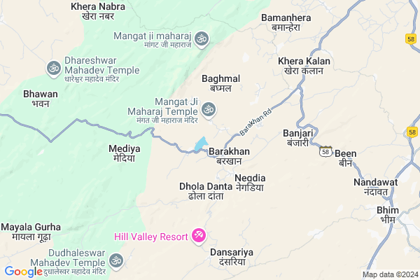
Satoo Khera Map
EDIT Map
Add Your House
 ..
..
Current Corona Virus Infected Patients Count in Ajmer District
| City Name | District Name | Total Covid cases |
|---|---|---|
| Ajmer District | Ajmer | 119 |
| Ajmer | Ajmer | 4 |
Locality Name :
Satoo Khera
( सत्तू खेरा )
Tehsil Name : Jawaja
District : Ajmer
State : Rajasthan
Division : Ajmer
Language : Rajasthani and Urdu, Rajasthani
Current Time 01:57 PM
Date: Tuesday , Apr 29,2025 (IST)
Time zone: IST (UTC+5:30)
Elevation / Altitude: 390 meters. Above Seal level
Assembly constituency : Beawar assembly constituency
Assembly MLA : Shankersingh Rawat
Lok Sabha constituency : Rajsamand parliamentary constituency
Parliament MP : Diya Kumari
Serpanch Name :
Main Village Name : Satoo Khera
Commodities Prices : Sojat Road Market / Mandi
National Highways Reachable To Satoo Khera
Nationa High Way :NH58
Nationa High Way :NH158
Nationa High Way :NH58
Nationa High Way :NH158
Rivers Near Satoo Khera
Khari
Sukari
Khari
Sukari
About Satoo Khera
Correct below Info and add more info about Satoo KheraSatoo Khera is a small Village/hamlet in Jawaja Tehsil in Ajmer District of Rajasthan State, India. It comes under Satoo Khera Panchayath. It belongs to Ajmer Division . It is located 118 KM towards South from District head quarters Ajmer. 43 KM from Jawaja. 260 KM from State capital Jaipur
Banjari ( 5 KM ) , Bamanhera ( 8 KM ) , Malaton Ki Ber ( 9 KM ) are the nearby Villages to Satoo Khera. Satoo Khera is surrounded by Kharchi(Mar.Jun) Tehsil towards west , Deogarh Tehsil towards South , Raipur Tehsil towards North , Jawaja Tehsil towards North .
Sojat , Jaitaran , Beawar , Bilara are the near by Cities to Satoo Khera.
Satoo Khera 2011 Census Details
Satoo Khera Local Language is Rajasthani. Satoo Khera Village Total population is 937 and number of houses are 202. Female Population is 49.2%. Village literacy rate is 57.4% and the Female Literacy rate is 22.0%.
Population
| Census Parameter | Census Data |
| Total Population | 937 |
| Total No of Houses | 202 |
| Female Population % | 49.2 % ( 461) |
| Total Literacy rate % | 57.4 % ( 538) |
| Female Literacy rate | 22.0 % ( 206) |
| Scheduled Tribes Population % | 1.8 % ( 17) |
| Scheduled Caste Population % | 9.3 % ( 87) |
| Working Population % | 49.4 % |
| Child(0 -6) Population by 2011 | 154 |
| Girl Child(0 -6) Population % by 2011 | 37.0 % ( 57) |
Satoo Khera Census More Deatils.
Politics in Satoo Khera
Bharatiya Janata Party , BJP , INC are the major political parties in this area.Polling Stations /Booths near Satoo Khera
1)Govt. Upper Priamary School Johar Khera2)Govt.patel Upper Primary School Rang Mahal Beawar
3)Govt.upper Priamary School Rudana
4)Govt. Sr. Secondary School Suradiya
5)Govt. Secondary School Khodmal
HOW TO REACH Satoo Khera
By Rail
There is no railway station near to Satoo Khera in less than 10 km.Pincodes near Satoo Khera
305926 ( Barakhera ) , 305924 ( Todgarh ) , 313341 ( Barar )Colleges near Satoo Khera
Govt. Iti College Tantoti
Address : Bhinay Road Tantoti
Dayanand College
Address :
Kirnani Technologies
Address :
Sanskar Itc
Address :
G.c.a.
Address : Ajmer
Schools near Satoo Khera
G.s. Jangid Memroil Sch.beawar
Address : np_beawar_ward no.45 , jawaja , ajmer , Rajasthan . PIN- 305901 , Post - Beawar [Raj]
Subodhani Internation School
Address : barakhan , jawaja , ajmer , Rajasthan . PIN- 305926 , Post - Barakhera
Kiran Public School Surajpura
Address : surajpura lotiyana , jawaja , ajmer , Rajasthan . PIN- 305923 , Post - Lotiyana
Matre Shiksha Sansthan Jaliya-1
Address : jaliya 1 , jawaja , ajmer , Rajasthan . PIN- 305926 , Post - Barakhera
Govt Health Centers near Satoo Khera
1) Thal , SC Thal , Thal , Thal2) Jinjardi , , ,
3) HARIYAMALI , GOVT.PRIMARY HEALTH CENTER HARIYAMALI , MAIN ROAD , MAIN ROAD
Sub Villages in Satoo Khera
Hospitals in Satoo Khera,Jawaja
Dr .N.K.Solanki & Rx C.P.Sirvi
rajsthan medical & chemist; Vopari; Rajasthan; India
22.8 KM distance Detail
more ..
Petrol Bunks in Satoo Khera,Jawaja
HP PETROL PUMP - HAMARA PUMP SARANGWAS
Tehsil Sojat; District Pali; Sarangwas; Rajasthan 306103; India
17.5 KM distance Detail
more ..
Schools in Satoo Khera,Jawaja
Government Upper Primary School Rad Jhalra
Rad Jhalra; Rajasthan 306023; India
13.9 KM distance Detail
Electronic Shops in Satoo Khera,Jawaja
Bhavani Repairing Cars Tractors and JCB Contractor
Kantaliya; Rajasthan 306103; India
18.6 KM distance Detail
Police Stations near Satoo Khera,Jawaja
About Satoo Khera &
History
How to reach Satoo Khera
Tourist Places Near By Satoo Khera
Schools in Satoo Khera
Colleges in Satoo Khera
Temperature & weather of Satoo Khera
places in Satoo Khera
Satoo Khera photos
More Information
How to reach Satoo Khera
Tourist Places Near By Satoo Khera
Schools in Satoo Khera
Colleges in Satoo Khera
Temperature & weather of Satoo Khera
places in Satoo Khera
Satoo Khera photos
More Information
Village Talk
Post News or Events about this Village
Near Cities
Sojat 41 KM near
Jaitaran 54 KM near
Beawar 54 KM near
Bilara 58 KM near
Sojat 41 KM near
Jaitaran 54 KM near
Beawar 54 KM near
Bilara 58 KM near
Near By Taluks
Bhim 10 KM near
Kharchi(Mar.Jun) 30 KM near
Deogarh 35 KM near
Raipur 40 KM near
Bhim 10 KM near
Kharchi(Mar.Jun) 30 KM near
Deogarh 35 KM near
Raipur 40 KM near
Near By Air Ports
Jodhpur Airport 121 KM near
Dabok Airport 143 KM near
Sanganeer Airport 240 KM near
Ahmedabad Airport 370 KM near
Jodhpur Airport 121 KM near
Dabok Airport 143 KM near
Sanganeer Airport 240 KM near
Ahmedabad Airport 370 KM near
Near By Tourist Places
Bhilwara 89 KM near
Ranakpur 98 KM near
Nathdwara 105 KM near
Pushkar 109 KM near
Kumbhalgarh 111 KM near
Bhilwara 89 KM near
Ranakpur 98 KM near
Nathdwara 105 KM near
Pushkar 109 KM near
Kumbhalgarh 111 KM near
Near By Districts
Pali 74 KM near
Rajsamand 88 KM near
Bhilwara 89 KM near
Ajmer 112 KM near
Pali 74 KM near
Rajsamand 88 KM near
Bhilwara 89 KM near
Ajmer 112 KM near
Near By RailWay Station
Sojat Road Rail Way Station 28 KM near
Marwar Junction Rail Way Station 42 KM near
Sojat Road Rail Way Station 28 KM near
Marwar Junction Rail Way Station 42 KM near