| Home | City Bus | Maps | Villages | Cities | Rail | Tourist Places | School | College | Pin Codes | Corona Cases Count |
| Distance Calculator Bus Services IFSC Codes Trace Mobile Number Weather Search Place Trace IP Available Cash ATM/Banks Locate Polling Booth Report an Error contact People |
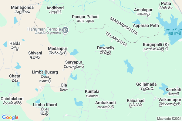
Rajapur Map
EDIT Map
Add Your House
 ..
..
Current Corona Virus Infected Patients Count in Adilabad District
| City Name | District Name | Total Covid cases |
|---|---|---|
| Adilabad District | Adilabad | 18 |
| Nirmal District | Nirmal | 17 |
Locality Name :
Rajapur
( రాజాపూర్ )
Mandal Name : Kuntala
District : Adilabad
State : Telangana
Region : Telangana
Language : Telugu and Urdu
Current Time 05:43 AM
Date: Monday , Apr 28,2025 (IST)
Time zone: IST (UTC+5:30)
Elevation / Altitude: 358 meters. Above Seal level
Telephone Code / Std Code: 08752
Assembly constituency : Mudhole assembly constituency
Assembly MLA : Ram Rao Pawar
Lok Sabha constituency : Adilabad parliamentary constituency
Parliament MP : SOYAM BAPU RAO
Serpanch Name :
Pin Code : 504109
Post Office Name : Kuntala
Main Village Name : Rajapur
Commodities Prices : Kuber Market / Mandi
Rajapur Live Weather
Temperature: 27.6 °C
few clouds
Humidity: 49%
Wind : 3.75 mt/sec towards S
StationName : "Bhaisa"
observed on Now
Temperature: 27.6 °C
few clouds
Humidity: 49%
Wind : 3.75 mt/sec towards S
StationName : "Bhaisa"
observed on Now
Rajapur Weather Forecast for Next 5 days
29-04-2025
29.2°C to 40.3°C
few clouds, clear sky, broken clouds
29.2°C to 40.3°C
few clouds, clear sky, broken clouds
30-04-2025
29.1°C to 42.3°C
scattered clouds, few clouds, clear sky
29.1°C to 42.3°C
scattered clouds, few clouds, clear sky
01-05-2025
29.7°C to 43.0°C
scattered clouds, few clouds, clear sky, broken clouds
29.7°C to 43.0°C
scattered clouds, few clouds, clear sky, broken clouds
02-05-2025
30.3°C to 43.7°C
scattered clouds, few clouds, clear sky, overcast clouds, broken clouds
30.3°C to 43.7°C
scattered clouds, few clouds, clear sky, overcast clouds, broken clouds
03-05-2025
29.9°C to 43.4°C
overcast clouds, scattered clouds, few clouds, clear sky, broken clouds
29.9°C to 43.4°C
overcast clouds, scattered clouds, few clouds, clear sky, broken clouds
Rivers Near Rajapur
Datki Vagu
Sikkumanu
Datki Vagu
Sikkumanu
About Rajapur
Correct below Info and add more info about RajapurRajapur is a small Village/hamlet in Kuntala Mandal in Adilabad District of Telangana State, India. It comes under Rajapur Panchayath. It belongs to Telangana region . It is located 81 KM towards South from District head quarters Adilabad. 6 KM from Kuntala.
Rajapur Pin code is 504109 and postal head office is Kuntala .
Ola ( 5 KM ) , Ambhakanti ( 6 KM ) , Vittapur ( 8 KM ) , Gulmadaga ( 8 KM ) , Andkur ( 9 KM ) are the nearby Villages to Rajapur. Rajapur is surrounded by Sarangapur Mandal towards East , Kubeer Mandal towards west , Dilawarpur Mandal towards South , Bhainsa Mandal towards west .
Bhainsa , Nirmal , Umarkhed , Nizamabad are the near by Cities to Rajapur.
Rajapur 2011 Census Details
Rajapur Local Language is Telugu. Rajapur Village Total population is 247 and number of houses are 56. Female Population is 48.2%. Village literacy rate is 27.5% and the Female Literacy rate is 8.1%.
Population
| Census Parameter | Census Data |
| Total Population | 247 |
| Total No of Houses | 56 |
| Female Population % | 48.2 % ( 119) |
| Total Literacy rate % | 27.5 % ( 68) |
| Female Literacy rate | 8.1 % ( 20) |
| Scheduled Tribes Population % | 96.4 % ( 238) |
| Scheduled Caste Population % | 0.0 % ( 0) |
| Working Population % | 54.7 % |
| Child(0 -6) Population by 2011 | 58 |
| Girl Child(0 -6) Population % by 2011 | 43.1 % ( 25) |
Rajapur Census More Deatils.
Politics in Rajapur
TDP , TRS , PRAP , BJP , INC are the major political parties in this area.Polling Stations /Booths near Rajapur
1)Doulatabad2)Sunkili
3)Mahalingi
4)Kumsara
5)Kuntala
HOW TO REACH Rajapur
By Rail
There is no railway station near to Rajapur in less than 10 km. are the Rail way stations reachable from near by towns.By Road
Bhainsa , Nirmal are the nearby by towns to Rajapur having road connectivity to RajapurColleges near Rajapur
Vasavi Junior College (inc), Kallur
Address : Kallur
Vasavi Degree College
Address : 2-264, Kallur (v), Kuntala (m), Adilabad Dist.
Schools in Rajapur
Mpps Rajapur Rajapur
Address : rajapur , kuntala , adilabad , Andhra Pradesh . PIN- 504109 , Post - Kuntala
Govt Health Centers near Rajapur
1) Primary Health Centre, Kuntala , , , Near Grama Panchayath office2) SubCentre, Kuntala , , , Opp: High School
3) SubCentre, Ola , , Beside Grampanchayat ,
Sub Villages in Rajapur
Colleges in Rajapur,Kuntala
Saraswathi Private ITI
Pipri Colony;Bhainsa Village;National Highway 222;Adilabad Dist; Pipri; Telangana 504103; India
18.8 KM distance Detail
more ..
Schools in Rajapur,Kuntala
Srujana High School .. Kothakapu Ganganna Gaaru
; Kuntala; Telangana 504109; India
5.0 KM distance Detail
Governement Offices near Rajapur,Kuntala
MeeSeva Center
near bustand;Kuntala(L);Kuntala(M);; Kuntala; Telangana 504109; India
4.6 KM distance Detail
About Rajapur &
History
How to reach Rajapur
Tourist Places Near By Rajapur
Schools in Rajapur
Colleges in Rajapur
Temperature & weather of Rajapur
places in Rajapur
Rajapur photos
More Information
How to reach Rajapur
Tourist Places Near By Rajapur
Schools in Rajapur
Colleges in Rajapur
Temperature & weather of Rajapur
places in Rajapur
Rajapur photos
More Information
Village Talk
Post News or Events about this Village
Near Cities
Bhainsa 20 KM near
Nirmal 31 KM near
Umarkhed 67 KM near
Nizamabad 68 KM near
Bhainsa 20 KM near
Nirmal 31 KM near
Umarkhed 67 KM near
Nizamabad 68 KM near
Near By Taluks
Kuntala 5 KM near
Sarangapur 18 KM near
Kubeer 19 KM near
Dilawarpur 20 KM near
Kuntala 5 KM near
Sarangapur 18 KM near
Kubeer 19 KM near
Dilawarpur 20 KM near
Near By Air Ports
Nanded Airport 92 KM near
Latur Airport 216 KM near
Rajiv Gandhi International Airport 248 KM near
Sonegaon Airport 259 KM near
Nanded Airport 92 KM near
Latur Airport 216 KM near
Rajiv Gandhi International Airport 248 KM near
Sonegaon Airport 259 KM near
Near By Tourist Places
Hingoli 128 KM near
Medak 145 KM near
Washim 158 KM near
Chandrapur 168 KM near
Bidar 175 KM near
Hingoli 128 KM near
Medak 145 KM near
Washim 158 KM near
Chandrapur 168 KM near
Bidar 175 KM near
Near By Districts
Nizamabad 67 KM near
Adilabad 77 KM near
Nanded 93 KM near
Hingoli 128 KM near
Nizamabad 67 KM near
Adilabad 77 KM near
Nanded 93 KM near
Hingoli 128 KM near
Near By RailWay Station
Himayatnagar Rail Way Station 37 KM near
Basar Rail Way Station 46 KM near
Himayatnagar Rail Way Station 37 KM near
Basar Rail Way Station 46 KM near