| Home | City Bus | Maps | Villages | Cities | Rail | Tourist Places | School | College | Pin Codes | Corona Cases Count |
| Distance Calculator Bus Services IFSC Codes Trace Mobile Number Weather Search Place Trace IP Available Cash ATM/Banks Locate Polling Booth Report an Error contact People |
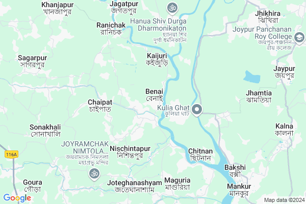
Benai
Benai Map
EDIT Map
Add Your House
 ..
..
Current Corona Virus Infected Patients Count in Medinipur West District
| City Name | District Name | Total Covid cases |
|---|
Locality Name :
Benai
( বেনাই )
Block Name : Daspur-ii
District : Medinipur West
State : West Bengal
Division : Burdwan
Language : Bengali
Current Time 11:44 AM
Date: Tuesday , Apr 29,2025 (IST)
Time zone: IST (UTC+5:30)
Elevation / Altitude: 9 meters. Above Seal level
Telephone Code / Std Code: 03225
Assembly constituency : Daspur assembly constituency
Assembly MLA : Mamata Bhunia
Lok Sabha constituency : Ghatal parliamentary constituency
Parliament MP : ADHIKARI DEEPAK (DEV)
Serpanch Name :
Pin Code : 721212
Post Office Name : Ghatal
Commodities Prices : Kolaghat Market / Mandi
Benai Live Weather
Temperature: 37.0 °C
clear sky
Humidity: 30%
Wind : 0.4 mt/sec towards SE
StationName : "GhÄ\u0081tÄ\u0081l"
observed on Now
Temperature: 37.0 °C
clear sky
Humidity: 30%
Wind : 0.4 mt/sec towards SE
StationName : "GhÄ\u0081tÄ\u0081l"
observed on Now
Benai Weather Forecast for Next 5 days
30-04-2025
24.2°C to 37.7°C
clear sky, light rain, moderate rain, scattered clouds, overcast clouds
24.2°C to 37.7°C
clear sky, light rain, moderate rain, scattered clouds, overcast clouds
01-05-2025
24.1°C to 36.8°C
broken clouds, clear sky, light rain, moderate rain, overcast clouds
24.1°C to 36.8°C
broken clouds, clear sky, light rain, moderate rain, overcast clouds
02-05-2025
23.2°C to 35.2°C
broken clouds, clear sky, scattered clouds, light rain, moderate rain, overcast clouds
23.2°C to 35.2°C
broken clouds, clear sky, scattered clouds, light rain, moderate rain, overcast clouds
03-05-2025
24.3°C to 36.3°C
overcast clouds, broken clouds, scattered clouds
24.3°C to 36.3°C
overcast clouds, broken clouds, scattered clouds
04-05-2025
25.6°C to 35.9°C
scattered clouds, clear sky, light rain, broken clouds, few clouds
25.6°C to 35.9°C
scattered clouds, clear sky, light rain, broken clouds, few clouds
National Highways Reachable To Benai
Nationa High Way :NH12
Nationa High Way :NH12
Rivers Near Benai
Hooghly :হুগলী :Hugli :Hooghly :Hugli :胡格利河
Hooghly :হুগলী :Hugli :Hooghly :Hugli :胡格利河
About Benai
Correct below Info and add more info about BenaiBenai is a Village in Daspur-ii Block in Medinipur West District of West Bengal State, India. It belongs to Burdwan Division . It is located 65 KM towards East from District head quarters Midnapore. 7 KM from Daspur-Ii. 62 KM from State capital Kolkata
Benai Pin code is 721212 and postal head office is Ghatal .
Dudhkomra ( 6 KM ) , Ranichak ( 6 KM ) , Sahachak ( 8 KM ) , Palashpai ( 9 KM ) , Khanjapur ( 11 KM ) are the nearby Villages to Benai. Benai is surrounded by Amta-Ii Block towards East , Khanakul-Ii Block towards North , Bagnan-I Block towards East , Ghatal Block towards west .
Uluberia , Tamluk , Panchla , Arambagh are the near by Cities to Benai.
This Place is in the border of the Medinipur West District and Hooghly District. Hooghly District Khanakul-ii is North towards this place . Also it is in the Border of other district Medinipur East .
Benai 2011 Census Details
Benai Local Language is Bengali. Benai Village Total population is 5731 and number of houses are 1213. Female Population is 48.9%. Village literacy rate is 71.3% and the Female Literacy rate is 32.2%.
Population
| Census Parameter | Census Data |
| Total Population | 5731 |
| Total No of Houses | 1213 |
| Female Population % | 48.9 % ( 2805) |
| Total Literacy rate % | 71.3 % ( 4087) |
| Female Literacy rate | 32.2 % ( 1847) |
| Scheduled Tribes Population % | 0.0 % ( 0) |
| Scheduled Caste Population % | 21.6 % ( 1237) |
| Working Population % | 33.9 % |
| Child(0 -6) Population by 2011 | 702 |
| Girl Child(0 -6) Population % by 2011 | 47.6 % ( 334) |
Benai Census More Deatils.
Politics in Benai
CPM , AITC , CPI , All India Trinamool Congress are the major political parties in this area.Polling Stations /Booths near Benai
1)Benai Maktab Pry. School Room -2 - 832)Benai Paschim Bhagabatitola Pry. School Room -1 - 84
3)Benai Atmayik Pry. School - 77
4)Alipur Pry. School
5)Arit Vivekananda Vidyamandir Room - 1 - 90
HOW TO REACH Benai
By Rail
There is no railway station near to Benai in less than 10 km.Colleges near Benai
Sankrail Anil Biswas Smriti Mahavidyalaya
Address :
Sabong Sajani Kanta Maha Vidyalaya
Address :
Garhbeta College
Address :
Nayagram Mahavidyalay
Address :
Subarnarekha Mahavidyalaya
Address :
Schools near Benai
Gopalpur Desbandhu Ch. Jr. U
Address : khanjapur-1 , daspur-2 , paschim medinipur , West Bengal . PIN- 721148 , Post - Kheput
Goura S.k.b.a.s. U.pry.
Address : goura-11 , daspur-2 , paschim medinipur , West Bengal . PIN- 721146 , Post - Sekendari
Sree Bora Girla H.school
Address : dud-komra-16 , daspur-2 , paschim medinipur , West Bengal . PIN- 721130 , Post - Gopalnagar (East Midnapore)
Rani Chak D.p. Hs U Pry.
Address : ranichak-1 , daspur-2 , paschim medinipur , West Bengal . PIN- 721212 , Post - Ghatal
Govt Health Centers near Benai
1) Benai SC , , , Near Benai Gram Panchyet Office2) Naihati SC , , , Near Shibtala Mandir
3) Uttar Barh SC , , , Near Artha Commission office
Petrol Bunks in Benai,Daspur-ii
HP PETROL PUMP - JANAPAYACHANA SERVICE STATION
Gopigunj Uttarbar ;p.o.kheput P.s.daspur; Durgapur; West Bengal 721148; India
2.2 KM distance Detail
Nandan Lubricants
Ghatal - Panskura Rd; Kuspata; Ghatal; West Bengal 721212; India
16.5 KM distance Detail
more ..
Colleges in Benai,Daspur-ii
Science Model Making
Soyla;sonakhali;paschim medinipur; Sonakhali; West Bengal 721146; India
9.7 KM distance Detail
Siddhivinayak B.Ed College
Ghatal - Panskura Rd; Sonamui; West Bengal 721146; India
13.5 KM distance Detail
Ghatal College of Education
Village- Harisinghpur; P.O.- Panchmaro Pratappur; Ghatal; West Bengal 721212; India
15.3 KM distance Detail
more ..
Schools in Benai,Daspur-ii
Panchgechia Joyramchak Gosthabehari Vidyapith
Panchgechia; Pin code-721148; Ghatal; West Bengal; India
6.7 KM distance Detail
Electronic Shops in Benai,Daspur-ii
Samanta Enterprise
chaipat; Uttar Bandth; Maity Para; Dori Ayodhya; West Bengal 721212; India
4.1 KM distance Detail
Chanchala Electric
Ranichak Super Market; Ranichak Road; West Bengal 721212; India
6.8 KM distance Detail
Governement Offices near Benai,Daspur-ii
No. 5 Chaipat Gram Panchayat Office
Kuigora;Ram Jangal Para; Chaipat To Ranichak Road; West Bengal 721212; India
3.2 KM distance Detail
Ranichak 3 No. Gram Panchyat
Ranichak Road; Ranichak; West Bengal 721212; India
6.2 KM distance Detail
Office of SI of School; Sonakhali Circle
2; Harekrishnapur Sonakhali Rd; Daspur; West Bengal 721211; India
8.6 KM distance Detail
About Benai &
History
How to reach Benai
Tourist Places Near By Benai
Schools in Benai
Colleges in Benai
Temperature & weather of Benai
places in Benai
Benai photos
More Information
How to reach Benai
Tourist Places Near By Benai
Schools in Benai
Colleges in Benai
Temperature & weather of Benai
places in Benai
Benai photos
More Information
Village Talk
Post News or Events about this Village
Near Cities
Uluberia 33 KM near
Tamluk 34 KM near
Panchla 34 KM near
Arambagh 40 KM near
Uluberia 33 KM near
Tamluk 34 KM near
Panchla 34 KM near
Arambagh 40 KM near
Near By Taluks
Daspur-Ii 7 KM near
Amta-Ii 10 KM near
Khanakul-Ii 11 KM near
Bagnan-I 15 KM near
Daspur-Ii 7 KM near
Amta-Ii 10 KM near
Khanakul-Ii 11 KM near
Bagnan-I 15 KM near
Near By Air Ports
Netaji Subhas Chandra Bose Airport 69 KM near
Ranchi Airport 303 KM near
Bhubaneswar Airport 371 KM near
Singerbhil Airport 422 KM near
Netaji Subhas Chandra Bose Airport 69 KM near
Ranchi Airport 303 KM near
Bhubaneswar Airport 371 KM near
Singerbhil Airport 422 KM near
Near By Tourist Places
Shankarpur 17 KM near
Howrah 48 KM near
Jairambati 50 KM near
Raichak 55 KM near
Alipore 56 KM near
Shankarpur 17 KM near
Howrah 48 KM near
Jairambati 50 KM near
Raichak 55 KM near
Alipore 56 KM near
Near By Districts
Medinipur East 35 KM near
Howrah 54 KM near
Kolkata 58 KM near
24 Paraganas South 60 KM near
Medinipur East 35 KM near
Howrah 54 KM near
Kolkata 58 KM near
24 Paraganas South 60 KM near
Near By RailWay Station
Mecheda Rail Way Station 19 KM near
Panskura Junction Rail Way Station 24 KM near
Mecheda Rail Way Station 19 KM near
Panskura Junction Rail Way Station 24 KM near