| Home | City Bus | Maps | Villages | Cities | Rail | Tourist Places | School | College | Pin Codes | Corona Cases Count |
| Distance Calculator Bus Services IFSC Codes Trace Mobile Number Weather Search Place Trace IP Available Cash ATM/Banks Locate Polling Booth Report an Error contact People |
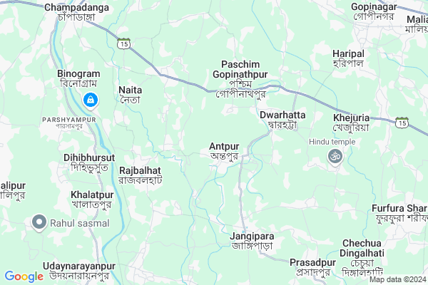
Antpur
Antpur Map
EDIT Map
Add Your House
 ..
..
Current Corona Virus Infected Patients Count in Hooghly District
| City Name | District Name | Total Covid cases |
|---|---|---|
| Hooghly District | Hooghly | 1 |
Locality Name :
Antpur
( অন্তঃপুর )
Block Name : Jangipara
District : Hooghly
State : West Bengal
Division : Burdwan
Language : Bengali
Current Time 09:10 AM
Date: Wednesday , Apr 30,2025 (IST)
Time zone: IST (UTC+5:30)
Elevation / Altitude: 14 meters. Above Seal level
Telephone Code / Std Code: 03214
Assembly constituency : Jangipara assembly constituency
Assembly MLA : Snehasis Chakraborty
Lok Sabha constituency : Serampore parliamentary constituency
Parliament MP : KALYAN BANERJEE
Serpanch Name :
Pin Code : 712424
Post Office Name : Antpur
Commodities Prices : Champadanga Market / Mandi
Edit below overview about Antpur
Edit below overview about Antpur
OverView of Antpur
Nearest station,haripal,distance, 13km,route, howrah-tarakeshwar,howrah-arambagh,howrah-goghat,local train, haripal is convenient station to reach antpur village,though,bahirkhanda is to some extent nearer,but no bus route is there to reach antpur.Edit below overview about Antpur
National Highways Reachable To Antpur
Nationa High Way :NH19
Nationa High Way :NH12
Nationa High Way :NH19
Nationa High Way :NH12
About Antpur
Antpur is a Village in Jangipara Block in Hooghly District of West Bengal State, India. It belongs to Burdwan Division . It is located 44 KM towards west from District head quarters Hugli-chuchura. 5 KM from Jangipara. 46 KM from State capital Kolkata
Antpur Pin code is 712424 and postal head office is Antpur .
Paschimgopinathpur ( 4 KM ) , Nabagram ( 4 KM ) , Rajbalhat-ii ( 5 KM ) , Rajbalhat-i ( 5 KM ) , Jangipara ( 5 KM ) are the nearby Villages to Antpur. Antpur is surrounded by Haripal Block towards North , Tarakeswar Block towards North , Pursurah Block towards west , Udaynarayanpur Block towards South .
Tarakeswar , Arambagh , Panchla , Monoharpur are the near by Cities to Antpur.
This Place is in the border of the Hooghly District and Howrah District. Howrah District Udaynarayanpur is South towards this place .
Demographics of Antpur
Bengali is the Local Language here.Politics in Antpur
CPM , CPI(M) , AITC , All India Trinamool Congress are the major political parties in this area.Polling Stations /Booths near Antpur
1)Ankuti Prathamik Bidyalay - Room - 12)Antpur Junior Uchcha Bidyalay - Room - 1
3)Antpur Prathamik Bidyalay - Room - 1
4)Antpur Prathamik Bidyalay - Room - 2
5)Soyari Prathamik Bidyalay - Room - 1
HOW TO REACH Antpur
By Rail
Kaikala Rail Way Station , Bahir Khanda Rail Way Station are the very nearby railway stations to Antpur.Colleges near Antpur
Bejoy Krishna College
Address :
Modern Institute Of Engineering And Technology
Address :
Hooghly Mohsin College
Address :
Schools near Antpur
Borhal Kd Pratisthan
Address : dilakash-x , jangipara , hugli , West Bengal . PIN- 712404 , Post - Jangipara
Rajbalhat Girls High
Address : rajbalhat-i/viii , jangipara , hugli , West Bengal . PIN- 712408 , Post - Rajbalhat
Jangipara Balika Vidyalay
Address : jangipara-xiv , jangipara , hugli , West Bengal . PIN- 712404 , Post - Jangipara
Laxmanpur Panchanan High Schoo
Address : mundalika-x , jangipara , hugli , West Bengal . PIN- 712404 , Post - Jangipara
Govt Health Centers near Antpur
1) Anarbati SC , Anarbati Sub-Centre , Antpur , Near Swami Premananda Vidyapith( Primary Section)2) Rajhati SC , Rajhati Sub-Centre , Antpur , Near Rajhati Primary School
3) Chaiman Chak SC , Chaiman Chak Sub-Centre , Antpur , Near Tarajal Bus Stand
Hospitals in Antpur,Jangipara
Medical Service Centre; Ramakrishna Math; Antpur
Kumarbazar; West Bengal 712424; India
1.3 KM distance Detail
more ..
Police Stations near Antpur,Jangipara
Jagatballavpur Police Station
SH-15; Howrah- Domjur- Bargachhia- Amta Road; Howrah; West Bengal 711408; India
8.7 KM distance Detail
Udaynarayanpur Police Station
Harali-Udaynarayanpur Road; Near BDO Office; Udaynarayanpur; West Bengal 711226; India
10.4 KM distance Detail
Governement Offices near Antpur,Jangipara
kamdevpur
Udaynarayanpur-Jagatballabhpur 1; Kamdebpur; West Bengal 712403; India
3.0 KM distance Detail
About Antpur &
History
How to reach Antpur
Tourist Places Near By Antpur
Schools in Antpur
Colleges in Antpur
Temperature & weather of Antpur
places in Antpur
Antpur photos
More Information
How to reach Antpur
Tourist Places Near By Antpur
Schools in Antpur
Colleges in Antpur
Temperature & weather of Antpur
places in Antpur
Antpur photos
More Information
Village Talk
Post News or Events about this Village
Near Cities
Tarakeswar 13 KM near
Arambagh 31 KM near
Panchla 32 KM near
Monoharpur 32 KM near
Tarakeswar 13 KM near
Arambagh 31 KM near
Panchla 32 KM near
Monoharpur 32 KM near
Near By Taluks
Jangipara 5 KM near
Haripal 10 KM near
Tarakeswar 12 KM near
Pursurah 12 KM near
Jangipara 5 KM near
Haripal 10 KM near
Tarakeswar 12 KM near
Pursurah 12 KM near
Near By Air Ports
Netaji Subhas Chandra Bose Airport 48 KM near
Ranchi Airport 318 KM near
Singerbhil Airport 391 KM near
Bhubaneswar Airport 406 KM near
Netaji Subhas Chandra Bose Airport 48 KM near
Ranchi Airport 318 KM near
Singerbhil Airport 391 KM near
Bhubaneswar Airport 406 KM near
Near By Tourist Places
Shankarpur 30 KM near
Howrah 34 KM near
Kolkata 45 KM near
Alipore 45 KM near
Jairambati 50 KM near
Shankarpur 30 KM near
Howrah 34 KM near
Kolkata 45 KM near
Alipore 45 KM near
Jairambati 50 KM near
Near By Districts
Howrah 39 KM near
Hooghly 43 KM near
Kolkata 47 KM near
24 Paraganas North 51 KM near
Howrah 39 KM near
Hooghly 43 KM near
Kolkata 47 KM near
24 Paraganas North 51 KM near
Near By RailWay Station
Seoraphuli Junction Rail Way Station 33 KM near
Santragachi Junction Rail Way Station 37 KM near
Seoraphuli Junction Rail Way Station 33 KM near
Santragachi Junction Rail Way Station 37 KM near