| Home | City Bus | Maps | Villages | Cities | Rail | Tourist Places | School | College | Pin Codes | Corona Cases Count |
| Distance Calculator Bus Services IFSC Codes Trace Mobile Number Weather Search Place Trace IP Available Cash ATM/Banks Locate Polling Booth Report an Error contact People |
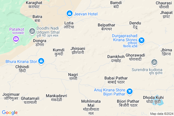
Lotiya
Lotiya Map
EDIT Map
Add Your House
 ..
..
Current Corona Virus Infected Patients Count in Chhindwara District
| City Name | District Name | Total Covid cases |
|---|---|---|
| Chhindwara District | Chhindwara | 5 |
Locality Name :
Lotiya
( लोटिया )
Tehsil Name : Tamia
District : Chhindwara
State : Madhya Pradesh
Division : Jabalpur
Language : Hindi and Bagheli,dravidian,devanagari
Current Time 07:01 PM
Date: Sunday , Apr 27,2025 (IST)
Time zone: IST (UTC+5:30)
Elevation / Altitude: 787 meters. Above Seal level
Telephone Code / Std Code: 07149
Assembly constituency : Amarwara assembly constituency
Assembly MLA : Kamlesh Pratap Shah
Lok Sabha constituency : Chhindwara parliamentary constituency
Parliament MP : NAKUL KAMAL NATH
Serpanch Name :
Pin Code : 480559
Post Office Name : Tamia
Commodities Prices : Amarwda Market / Mandi
Lotiya Live Weather
Temperature: 29.5 °C
broken clouds
Humidity: 14%
Wind : 0.77 mt/sec towards S
StationName : "ParÄ\u0081sia"
observed on Now
Temperature: 29.5 °C
broken clouds
Humidity: 14%
Wind : 0.77 mt/sec towards S
StationName : "ParÄ\u0081sia"
observed on Now
Lotiya Weather Forecast for Next 5 days
28-04-2025
23.5°C to 27.8°C
broken clouds
23.5°C to 27.8°C
broken clouds
29-04-2025
21.7°C to 36.6°C
scattered clouds, clear sky, few clouds, broken clouds, overcast clouds
21.7°C to 36.6°C
scattered clouds, clear sky, few clouds, broken clouds, overcast clouds
30-04-2025
25.7°C to 38.1°C
broken clouds, clear sky, scattered clouds
25.7°C to 38.1°C
broken clouds, clear sky, scattered clouds
01-05-2025
26.3°C to 38.9°C
scattered clouds, clear sky
26.3°C to 38.9°C
scattered clouds, clear sky
02-05-2025
26.1°C to 39.2°C
scattered clouds, clear sky, broken clouds
26.1°C to 39.2°C
scattered clouds, clear sky, broken clouds
National Highways Reachable To Lotiya
Nationa High Way :NH547
Nationa High Way :NH547
Rivers Near Lotiya
Dhar Nadi
Thei
Dhar Nadi
Thei
About Lotiya
Correct below Info and add more info about LotiyaLotiya is a Village in Tamia Tehsil in Chhindwara District of Madhya Pradesh State, India. It belongs to Jabalpur Division . It is located 44 KM towards North from District head quarters Chhindwara. 23 KM from Tamia. 210 KM from State capital Bhopal
Lotiya Pin code is 480559 and postal head office is Tamia .
Bhoipar ( 8 KM ) , Bijoripathar ( 8 KM ) , Chhindi ( 9 KM ) , Kahua ( 10 KM ) , Dhodakuhi ( 11 KM ) are the nearby Villages to Lotiya. Lotiya is surrounded by Parasia Tehsil towards South , Amarwara Tehsil towards East , Harrai Tehsil towards East , Chhindwara Tehsil towards South .
Chhindwara , Pipariya , Seoni , Sohagpur are the near by Cities to Lotiya.
Lotiya 2011 Census Details
Lotiya Local Language is Hindi. Lotiya Village Total population is 1756 and number of houses are 336. Female Population is 49.5%. Village literacy rate is 45.4% and the Female Literacy rate is 17.8%.
Population
| Census Parameter | Census Data |
| Total Population | 1756 |
| Total No of Houses | 336 |
| Female Population % | 49.5 % ( 869) |
| Total Literacy rate % | 45.4 % ( 797) |
| Female Literacy rate | 17.8 % ( 312) |
| Scheduled Tribes Population % | 74.5 % ( 1309) |
| Scheduled Caste Population % | 1.1 % ( 20) |
| Working Population % | 50.9 % |
| Child(0 -6) Population by 2011 | 297 |
| Girl Child(0 -6) Population % by 2011 | 48.1 % ( 143) |
Lotiya Census More Deatils.
Politics in Lotiya
Indian National Congress , BJP , INC are the major political parties in this area.Polling Stations /Booths near Lotiya
1)Jhirana2)Nachana
3)Chimauua
4)Churisajava
5)Chopana
HOW TO REACH Lotiya
By Rail
There is no railway station near to Lotiya in less than 10 km.Colleges near Lotiya
Arts And Coollege
Address :
Vidhya Devi Shukla Mahavidhyalay
Address :
Govt. College Bichhua
Address :
Priyadarshni Science & Management Technology College Sausar
Address :
S S College
Address :
Schools in Lotiya
G.m.s.lotiya
Address : lotiya , tamia , chhindwara , Madhya Pradesh . PIN- 480559 , Post - Tamia
M.s.lotiya
Address : lotiya , tamia , chhindwara , Madhya Pradesh . PIN- 480559 , Post - Tamia
Govt Health Centers near Lotiya
1) SHC Nagri , Nagri , Nagri , Nagri2) SHC Chopna , SHC Chopna , SHC Chopna , Chopna
3) SHC Lotiya , Lotiya , Lotiya , Lotiya
Hospitals in Lotiya,Tamia
Govt. Hospital Batkakhapa
Main Road; Batkakhapa; Madhya Pradesh 480224; India
22.1 KM distance Detail
more ..
Schools in Lotiya,Tamia
Primary School Tursi
Parasia; primary School; Tursi; Madhya Pradesh 480557; India
16.5 KM distance Detail
Local Parks in Lotiya,Tamia
Governement Offices near Lotiya,Tamia
About Lotiya &
History
How to reach Lotiya
Tourist Places Near By Lotiya
Schools in Lotiya
Colleges in Lotiya
Temperature & weather of Lotiya
places in Lotiya
Lotiya photos
More Information
How to reach Lotiya
Tourist Places Near By Lotiya
Schools in Lotiya
Colleges in Lotiya
Temperature & weather of Lotiya
places in Lotiya
Lotiya photos
More Information
Village Talk
Post News or Events about this Village
Near Cities
Chhindwara 41 KM near
Pipariya 76 KM near
Seoni 86 KM near
Sohagpur 88 KM near
Chhindwara 41 KM near
Pipariya 76 KM near
Seoni 86 KM near
Sohagpur 88 KM near
Near By Taluks
Tamia 22 KM near
Parasia 31 KM near
Amarwara 34 KM near
Harrai 34 KM near
Tamia 22 KM near
Parasia 31 KM near
Amarwara 34 KM near
Harrai 34 KM near
Near By Air Ports
Jabalpur Airport 122 KM near
Sonegaon Airport 164 KM near
Bhopal Airport 210 KM near
Khajuraho Airport 322 KM near
Jabalpur Airport 122 KM near
Sonegaon Airport 164 KM near
Bhopal Airport 210 KM near
Khajuraho Airport 322 KM near
Near By Tourist Places
Pachmarhi 54 KM near
Seoni 84 KM near
Pench National Park 103 KM near
Itarsi 135 KM near
Bhedaghat 138 KM near
Pachmarhi 54 KM near
Seoni 84 KM near
Pench National Park 103 KM near
Itarsi 135 KM near
Bhedaghat 138 KM near
Near By Districts
Chhindwara 42 KM near
Narsinghpur 74 KM near
Seoni 84 KM near
Betul 131 KM near
Chhindwara 42 KM near
Narsinghpur 74 KM near
Seoni 84 KM near
Betul 131 KM near
Near By RailWay Station
Gadarwara Rail Way Station 63 KM near
Kareli Rail Way Station 68 KM near
Gadarwara Rail Way Station 63 KM near
Kareli Rail Way Station 68 KM near