| Home | City Bus | Maps | Villages | Cities | Rail | Tourist Places | School | College | Pin Codes | Corona Cases Count |
| Distance Calculator Bus Services IFSC Codes Trace Mobile Number Weather Search Place Trace IP Available Cash ATM/Banks Locate Polling Booth Report an Error contact People |
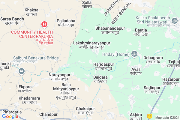
Haridaspur
Haridaspur Map
EDIT Map
Add Your House
 ..
..
Current Corona Virus Infected Patients Count in Birbhum District
| City Name | District Name | Total Covid cases |
|---|
Locality Name :
Haridaspur
( হরিদাসপুর )
Block Name : Nalhati-i
District : Birbhum
State : West Bengal
Division : Burdwan
Language : Bengali and English
Current Time 07:40 AM
Date: Saturday , Apr 26,2025 (IST)
Time zone: IST (UTC+5:30)
Elevation / Altitude: 40 meters. Above Seal level
Telephone Code / Std Code: 03465
Assembly constituency : Nalhati assembly constituency
Assembly MLA : Rajendra Prasad Singh (RAJU SINGH)
Lok Sabha constituency : Birbhum parliamentary constituency
Parliament MP : SATABDI ROY
Serpanch Name :
Pin Code : 731243
Post Office Name : Nalhati Township
Commodities Prices : Rampurhat Market / Mandi
Rivers Near Haridaspur
Brahmani
lal pokhra
Brahmani
lal pokhra
About Haridaspur
Correct below Info and add more info about HaridaspurHaridaspur is a Village in Nalhati-i Block in Birbhum District of West Bengal State, India. It belongs to Burdwan Division . It is located 51 KM towards North from District head quarters Suri, Birbhum. 15 KM from Nalhati-I. 231 KM from State capital Kolkata
Haridaspur Pin code is 731243 and postal head office is Nalhati Township .
Ayas ( 6 KM ) , Bautia ( 7 KM ) , Kusumba ( 8 KM ) , Horisara ( 9 KM ) , Rampur ( 11 KM ) are the nearby Villages to Haridaspur. Haridaspur is surrounded by Nalhati-Ii Block towards East , Pakuria Block towards North , Rampurhat-Ii Block towards South , Nalhati-I Block towards East .
Rampurhat , Suri , Pakaur , Sainthia are the near by Cities to Haridaspur.
This Place is in the border of the Birbhum District and Pakur District. Pakur District Maheshpur is North towards this place . It is near to the Jharkhand State Border.
Haridaspur 2011 Census Details
Haridaspur Local Language is Bengali. Haridaspur Village Total population is 2856 and number of houses are 693. Female Population is 48.6%. Village literacy rate is 61.1% and the Female Literacy rate is 25.1%.
Population
| Census Parameter | Census Data |
| Total Population | 2856 |
| Total No of Houses | 693 |
| Female Population % | 48.6 % ( 1387) |
| Total Literacy rate % | 61.1 % ( 1746) |
| Female Literacy rate | 25.1 % ( 716) |
| Scheduled Tribes Population % | 24.3 % ( 694) |
| Scheduled Caste Population % | 30.0 % ( 858) |
| Working Population % | 45.4 % |
| Child(0 -6) Population by 2011 | 357 |
| Girl Child(0 -6) Population % by 2011 | 50.4 % ( 180) |
Haridaspur Census More Deatils.
Politics in Haridaspur
FBL , AITC , AIFB , INC are the major political parties in this area.Polling Stations /Booths near Haridaspur
1)Karimpur Prathamik Vidyalay Room No-ii2)Tezhati J.m. High School Room-i
3)Habishpur C.b. Prathamaikvidalay Class-ii
4)Kusumjali Primary School Room-i
5)Lakshinarayanpur Junior High School
HOW TO REACH Haridaspur
By Rail
Swadinpur Rail Way Station is the very nearby railway stations to Haridaspur.Colleges near Haridaspur
Sailajananda Falguni Smriti Mahavidyalaya
Address :
Kabi Nazrul College
Address :
Turku Hansda Lapsa Hemrom Mahavidlaya
Address :
Basantika College Of Engeneering And Technology(polytechnic)
Address :
Suri Vidyasagar College
Address :
Schools near Haridaspur
Amaipur Milani High Madrasha
Address : kalitha-i , nalhati-i , birbhum , West Bengal . PIN- 731220 , Post - Nalhati
Mustafadanga A.m.u. Sr.madrasa
Address : kaytha-i/vii , nalhati-i , birbhum , West Bengal . PIN- 731220 , Post - Nalhati
Tejhati Jasamanta High School
Address : kurumgram-viii , nalhati-i , birbhum , West Bengal . PIN- 731220 , Post - Nalhati
Kaytha High School
Address : kaytha-i/iii , nalhati-i , birbhum , West Bengal . PIN- 731220 , Post - Nalhati
Govt Health Centers near Haridaspur
1) Haridaspur SC , Haridaspur SC , ,2) Baidhara PHC , Baidhara PHC , Baidhara , Turukdighi Kalitala
3) Baidhara SC , Baidhara , BAIDHARA , Kalitala
Hospitals in Haridaspur,Nalhati-i
Narayanpur Primary Health Centre
Hospital Lane; Narayanpur; West Bengal 731223; India
5.4 KM distance Detail
more ..
Petrol Bunks in Haridaspur,Nalhati-i
NALHATESWARI FILLING CENTRE
BAHADURPUR;KADASIR;BIRBHUM; BIRBHUM; West Bengal 731243; India
10.4 KM distance Detail
more ..
Colleges in Haridaspur,Nalhati-i
Gurukul Teachers Training Centre
Bholla Sulfula Canal Rd; Batail; West Bengal 731224; India
11.2 KM distance Detail
Rampurhat Medical College & District Hospital
Hospital More;; Rampurhat; West Bengal; India
11.8 KM distance Detail
more ..
Schools in Haridaspur,Nalhati-i
lakshminarayanpur C.B. Primary school
Lakshminarayanpur; West Bengal 731243; India
1.3 KM distance Detail
Lakshminarayanpur A.J.A. High School
Lakshminarayanpur; West Bengal 731243; India
1.3 KM distance Detail
Police Stations near Haridaspur,Nalhati-i
Nischintapur Police Phari
Ayas Road; Rampurhat; Rampurhat; West Bengal; India
12.0 KM distance Detail
About Haridaspur &
History
How to reach Haridaspur
Tourist Places Near By Haridaspur
Schools in Haridaspur
Colleges in Haridaspur
Temperature & weather of Haridaspur
places in Haridaspur
Haridaspur photos
More Information
How to reach Haridaspur
Tourist Places Near By Haridaspur
Schools in Haridaspur
Colleges in Haridaspur
Temperature & weather of Haridaspur
places in Haridaspur
Haridaspur photos
More Information
Village Talk
Post News or Events about this Village
Near Cities
Rampurhat 12 KM near
Suri 45 KM near
Pakaur 48 KM near
Sainthia 49 KM near
Rampurhat 12 KM near
Suri 45 KM near
Pakaur 48 KM near
Sainthia 49 KM near
Near By Taluks
Rampurhat-I 11 KM near
Nalhati-Ii 12 KM near
Pakuria 12 KM near
Rampurhat-Ii 14 KM near
Rampurhat-I 11 KM near
Nalhati-Ii 12 KM near
Pakuria 12 KM near
Rampurhat-Ii 14 KM near
Near By Air Ports
Netaji Subhas Chandra Bose Airport 216 KM near
Ranchi Airport 298 KM near
Bagdogra Airport 309 KM near
Gaya Airport 321 KM near
Netaji Subhas Chandra Bose Airport 216 KM near
Ranchi Airport 298 KM near
Bagdogra Airport 309 KM near
Gaya Airport 321 KM near
Near By Tourist Places
Suri 48 KM near
Pakur 48 KM near
Dumka 54 KM near
Murshidabad 62 KM near
Santiniketan 72 KM near
Suri 48 KM near
Pakur 48 KM near
Dumka 54 KM near
Murshidabad 62 KM near
Santiniketan 72 KM near
Near By Districts
Pakur 49 KM near
Birbhum 49 KM near
Dumka 54 KM near
Murshidabad 64 KM near
Pakur 49 KM near
Birbhum 49 KM near
Dumka 54 KM near
Murshidabad 64 KM near
Near By RailWay Station
Rampurhat Junction Rail Way Station 11 KM near
Nalhati Junction Rail Way Station 12 KM near
Rampurhat Junction Rail Way Station 11 KM near
Nalhati Junction Rail Way Station 12 KM near