| Home | City Bus | Maps | Villages | Cities | Rail | Tourist Places | School | College | Pin Codes | Corona Cases Count |
| Distance Calculator Bus Services IFSC Codes Trace Mobile Number Weather Search Place Trace IP Available Cash ATM/Banks Locate Polling Booth Report an Error contact People |
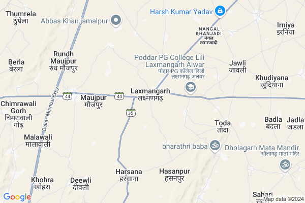
Laxmangarh
Laxmangarh Map
EDIT Map
Add Your House
 ..
..
Current Corona Virus Infected Patients Count in Alwar District
| City Name | District Name | Total Covid cases |
|---|---|---|
| Alwar District | Alwar | 7 |
Locality Name :
Laxmangarh
( लष्मणगढ़ )
Tehsil Name : Lachhmangarh
District : Alwar
State : Rajasthan
Division : Jaipur
Language : Rajasthani
Current Time 01:15 PM
Date: Sunday , Mar 30,2025 (IST)
Time zone: IST (UTC+5:30)
Elevation / Altitude: 278 meters. Above Seal level
Telephone Code / Std Code: 01468
Assembly constituency : Ramgarh assembly constituency
Assembly MLA :
Lok Sabha constituency : Bharatpur parliamentary constituency
Parliament MP :
Serpanch Name :
Pin Code : 321607
Post Office Name : Laxman Garh
Alternate Village Name : Lachhmangarh
Commodities Prices : Mahuwa Mandawar Market / Mandi
Edit below overview about Laxmangarh
Edit below overview about Laxmangarh
OverView of Laxmangarh
Village rasoolpur is falling in lachhmangarh tehsil. Distance 13 km.lachhman Garh tehsil has a large area. Pradhan of lachhman garh panchayaat samiti is Mrs.Seems MeenaEdit below overview about Laxmangarh
National Highways Reachable To Laxmangarh
Nationa High Way :NH248A
Nationa High Way :NH919
Nationa High Way :NH248A
Nationa High Way :NH919
About Laxmangarh
Laxmangarh is a Town in Lachhmangarh Tehsil in Alwar District of Rajasthan State, India. It belongs to Jaipur Division . It is located 40 KM towards East from District head quarters Alwar. It is a Tehsil head quarter.
Laxmangarh Pin code is 321607 and postal head office is Laxman Garh .
Sorai ( 3 KM ) , Maujpur ( 4 KM ) , Toda ( 6 KM ) , Nangal Khanjadi ( 6 KM ) , Harsana ( 6 KM ) are the nearby Villages to Laxmangarh. Laxmangarh is surrounded by Kathumar Tehsil towards East , Reni Tehsil towards South , Ramgarh Tehsil towards North , Umren Tehsil towards west .
Nagar , Rajgarh (Alwar) , Alwar , Mahwa are the nearby Cities to Laxmangarh.
Laxmangarh 2011 Census Details
Laxmangarh Local Language is Rajasthani. Laxmangarh town Total population is 11306 and number of houses are 1992. Female Population is 47.2%. town literacy rate is 68.6% and the Female Literacy rate is 27.6%.
Population
| Census Parameter | Census Data |
| Total Population | 11306 |
| Total No of Houses | 1992 |
| Female Population % | 47.2 % ( 5331) |
| Total Literacy rate % | 68.6 % ( 7753) |
| Female Literacy rate | 27.6 % ( 3123) |
| Scheduled Tribes Population % | 3.8 % ( 426) |
| Scheduled Caste Population % | 15.9 % ( 1798) |
| Working Population % | 38.4 % |
| Child(0 -6) Population by 2011 | 1615 |
| Girl Child(0 -6) Population % by 2011 | 45.5 % ( 735) |
Laxmangarh Census More Deatils.
Demographics of Laxmangarh
Rajasthani is the Local Language here.Politics in Laxmangarh
Bharatiya Janata Party , BJP , INC are the major political parties in this area.Polling Stations /Booths near Laxmangarh
1)Govt.sr.sec.school Nashopur2)Govt.sec.school Meenapura
3)Govt.sr.sec.school Malpur
4)Govt.upp.pri.school Sahajpur
5)Govt.upp.pri.school Sahajpur (east Part)
HOW TO REACH Laxmangarh
By Rail
There is no railway station near to Laxmangarh in less than 10 km.Govt Health Centers near Laxmangarh
1) Thekda , , ,2) Soarai , , sorai ,
3) Mojpur , , mojpur ,
Hospitals in Laxmangarh,Lachhmangarh
Dr.nandram saini
Laxmangarh to Malakhera; Laxmangarh; Rajasthan 321607; India
0.6 KM distance Detail
more ..
Petrol Bunks in Laxmangarh,Lachhmangarh
HP PETROL PUMP - KHANDELWAL & SONS
Lachmangarh Distt Rajasthan; Jaipur; Rajasthan 321607; India
0.7 KM distance Detail
Prem Chand Kishan Chand Jain-Bharat Petroleum
Lakshmangarh; Alwar; SH-44; Alwar Road; Rajgarh; Rajgarh; Rajasthan 321607; India
0.7 KM distance Detail
more ..
Colleges in Laxmangarh,Lachhmangarh
vinayak ITI college
Jaluki Road; Front of Power House; Laxmangarh; Rajasthan 321607; India
0.6 KM distance Detail
Smt Shakuntala Shukla Mahila PG College
Jain Bhawan; RJ SH 35; Laxmangarh; Rajasthan 321607; India
0.6 KM distance Detail
Gramotthan Vidyapeeth PG MaHila Mahavidyalaya
Laxmangarh; Rajasthan 321607; India
0.7 KM distance Detail
Swami Keshwanand BSTC College; Laxmangarh
Laxmangarh; Rajasthan 321607; India
0.7 KM distance Detail
more ..
Schools in Laxmangarh,Lachhmangarh
Chaildren Home Sr.sec. School
state bank street fakir mohalla; Laxmangarh; Rajasthan; India
0.5 KM distance Detail
Lok Shiksha Center
Laxmangarh; Alwar; SH-44; Alwar Road; Rajgarh; Rajgarh; Rajasthan 321207; India
0.6 KM distance Detail
Electronic Shops in Laxmangarh,Lachhmangarh
Mahavir Jain
Sardar Tent House Road; Jain Nagar; Ludhiana; Punjab 141001; India
0.5 KM distance Detail
Super Markets in Laxmangarh,Lachhmangarh
साजिद सिलाई मशीन रिपेयर्स
kamal tent house; Malakhera; road; Laxmangarh; Rajasthan 321607; India
0.6 KM distance Detail
Governement Offices near Laxmangarh,Lachhmangarh
Tehsildar Office
Laxmangarh; Alwar; SH-44; Alwar Road; Rajgarh; Rajgarh; Rajasthan 321607; India
0.6 KM distance Detail
Atal Seva Center
Lakshmangarh; Alwar; SH-44; Alwar Road; Rajgarh; Rajgarh; Rajasthan 321207; India
0.6 KM distance Detail
About Laxmangarh &
History
How to reach Laxmangarh
Tourist Places Near By Laxmangarh
Schools in Laxmangarh
Colleges in Laxmangarh
Temperature & weather of Laxmangarh
places in Laxmangarh
Laxmangarh photos
More Information
How to reach Laxmangarh
Tourist Places Near By Laxmangarh
Schools in Laxmangarh
Colleges in Laxmangarh
Temperature & weather of Laxmangarh
places in Laxmangarh
Laxmangarh photos
More Information
Town Talk
Post News or Events about this Town
Near Cities
Nagar 27 KM near
Rajgarh (Alwar) 30 KM near
Alwar 37 KM near
Mahwa 40 KM near
Nagar 27 KM near
Rajgarh (Alwar) 30 KM near
Alwar 37 KM near
Mahwa 40 KM near
Near By Taluks
Lachhmangarh 6 KM near
Kathumar 17 KM near
Reni 24 KM near
Ramgarh 28 KM near
Lachhmangarh 6 KM near
Kathumar 17 KM near
Reni 24 KM near
Ramgarh 28 KM near
Near By Air Ports
Kheria Airport 124 KM near
Sanganeer Airport 135 KM near
Indira Gandhi International Airport 151 KM near
Gwalior Airport 202 KM near
Kheria Airport 124 KM near
Sanganeer Airport 135 KM near
Indira Gandhi International Airport 151 KM near
Gwalior Airport 202 KM near
Near By Tourist Places
Alwar 37 KM near
Sariska 53 KM near
Govardhan 68 KM near
Kalakho 69 KM near
Bharatpur 71 KM near
Alwar 37 KM near
Sariska 53 KM near
Govardhan 68 KM near
Kalakho 69 KM near
Bharatpur 71 KM near
Near By Districts
Alwar 38 KM near
Bharatpur 72 KM near
Dausa 83 KM near
Mathura 91 KM near
Alwar 38 KM near
Bharatpur 72 KM near
Dausa 83 KM near
Mathura 91 KM near
Near By RailWay Station
Kherli Rail Way Station 28 KM near
Rajgarh Rail Way Station 31 KM near
Kherli Rail Way Station 28 KM near
Rajgarh Rail Way Station 31 KM near