| Home | City Bus | Maps | Villages | Cities | Rail | Tourist Places | School | College | Pin Codes | Corona Cases Count |
| Distance Calculator Bus Services IFSC Codes Trace Mobile Number Weather Search Place Trace IP Available Cash ATM/Banks Locate Polling Booth Report an Error contact People |
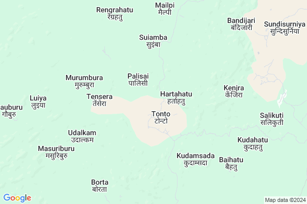
Katebasa
Katebasa Map
EDIT Map
Add Your House
 ..
..
Current Corona Virus Infected Patients Count in West Singhbhum District
| City Name | District Name | Total Covid cases |
|---|
Locality Name :
Katebasa
( कटबासा )
Block Name : Tonto
District : West Singhbhum
State : Jharkhand
Language : Hindi and Santali
Current Time 12:05 PM
Date: Friday , Mar 14,2025 (IST)
Time zone: IST (UTC+5:30)
Elevation / Altitude: 366 meters. Above Seal level
Telephone Code / Std Code: 06589
Assembly constituency : Chaibasa assembly constituency
Assembly MLA : DEEPAK BIRUA
Lok Sabha constituency : Singhbhum parliamentary constituency
Parliament MP : GEETA KORA
Serpanch Name :
Main Village Name : Daudongoa
Commodities Prices : Karanjia Market / Mandi
National Highways Reachable To Katebasa
Nationa High Way :NH320G
Nationa High Way :NH320D
Nationa High Way :NH320G
Nationa High Way :NH320D
Rivers Near Katebasa
Kalia
Koel River :Koel River
Kalia
Koel River :Koel River
About Katebasa
Correct below Info and add more info about KatebasaKatebasa is a small Village/hamlet in Tonto Block in West Singhbhum District of Jharkhand State, India. It comes under Daudongoa Panchayath. It is located 31 KM towards west from District head quarters Chaibasa. 128 KM from State capital Ranchi
Katebasa is surrounded by Jhinkpani Block towards East , Goelkera Block towards west , Jagannathpur Block towards South , Noamundi Block towards South .
Chaibasa , Chakradharpur , Barbil , Joda are the near by Cities to Katebasa.
Demographics of Katebasa
Hindi is the Local Language here.Politics in Katebasa
Indian National Congress , JBSP , BJP , JMM , INC are the major political parties in this area.Polling Stations /Booths near Katebasa
1)P.s. Gutusai Chaibasa2)M.s. Siringsiya(east Block)
3)P.s. Sonaposi
4)P.s Ulihatu
5)M.s Sindri (east Part)
HOW TO REACH Katebasa
By Rail
There is no railway station near to Katebasa in less than 10 km.Pincodes near Katebasa
833218 ( Noamundi Bazar ) , 833215 ( Jhinkpani ) , 833105 ( Sonua )Colleges near Katebasa
Degree College Jagannathpur
Address : College Name Degree College Jagannathpur: degree College Jagannathpur
college Alternate Name : degree College Jagannathpur
city/village :jagannathpur jharkhand, West Singhbhum , Jagannathpur , Jagannathpur
public/private : public
college Type art
St. Augustine College, Manoharpur
Address : Same As College.
Jagannathpur Inter College
Address :
Inter College Manjhgaon
Address :
Kolhan University Chaibasa
Address :
Schools near Katebasa
Govt Health Centers near Katebasa
1) CHC TONTO , , ,2) HSC TONTO , , ,
3) HSC TENSARA , , ,
Petrol Bunks in Katebasa,Tonto
Bharat Petroleum Fuel Station; Jhinkpani.
National Highway 75; Jhinkpani; Jorapokhar; Jharkhand 833215; India
20.6 KM distance Detail
Bharat Petroleum: Kolhan Fuel Station.
Jharkhand State Highway 4; Jagannathpur; Jharkhand 833203; India
23.3 KM distance Detail
more ..
Electronic Shops in Katebasa,Tonto
New Ankit Telecom
takta Bazar pin -833215; Jhinkpani; Jorapokhar; Jharkhand 833215; India
20.0 KM distance Detail
Police Stations near Katebasa,Tonto
Hat Gamhariya Police Station.
National Highway 75; Haat Gamhariya; Jharkhand 833214; India
23.2 KM distance Detail
About Katebasa &
History
How to reach Katebasa
Tourist Places Near By Katebasa
Schools in Katebasa
Colleges in Katebasa
Temperature & weather of Katebasa
places in Katebasa
Katebasa photos
More Information
How to reach Katebasa
Tourist Places Near By Katebasa
Schools in Katebasa
Colleges in Katebasa
Temperature & weather of Katebasa
places in Katebasa
Katebasa photos
More Information
Village Talk
Post News or Events about this Village
Near Cities
Chaibasa 29 KM near
Chakradharpur 34 KM near
Barbil 41 KM near
Joda 51 KM near
Chaibasa 29 KM near
Chakradharpur 34 KM near
Barbil 41 KM near
Joda 51 KM near
Near By Taluks
Tonto 0 KM near
Jhinkpani 21 KM near
Goelkera 28 KM near
Noamundi 29 KM near
Tonto 0 KM near
Jhinkpani 21 KM near
Goelkera 28 KM near
Noamundi 29 KM near
Near By Air Ports
Ranchi Airport 118 KM near
Bhubaneswar Airport 268 KM near
Gaya Airport 301 KM near
Netaji Subhas Chandra Bose Airport 328 KM near
Ranchi Airport 118 KM near
Bhubaneswar Airport 268 KM near
Gaya Airport 301 KM near
Netaji Subhas Chandra Bose Airport 328 KM near
Near By Tourist Places
Seraikela 53 KM near
Rourkela 84 KM near
Jamshedpur 85 KM near
Dassam Falls 98 KM near
Chotanagpur 101 KM near
Seraikela 53 KM near
Rourkela 84 KM near
Jamshedpur 85 KM near
Dassam Falls 98 KM near
Chotanagpur 101 KM near
Near By Districts
West Singhbhum 29 KM near
Saraikela Kharsawan 53 KM near
East Singhbum 83 KM near
Khunti 91 KM near
West Singhbhum 29 KM near
Saraikela Kharsawan 53 KM near
East Singhbum 83 KM near
Khunti 91 KM near
Near By RailWay Station
Goilkera Rail Way Station 28 KM near
Dangoaposi Rail Way Station 28 KM near
Goilkera Rail Way Station 28 KM near
Dangoaposi Rail Way Station 28 KM near