| Home | City Bus | Maps | Villages | Cities | Rail | Tourist Places | School | College | Pin Codes | Corona Cases Count |
| Distance Calculator Bus Services IFSC Codes Trace Mobile Number Weather Search Place Trace IP Available Cash ATM/Banks Locate Polling Booth Report an Error contact People |
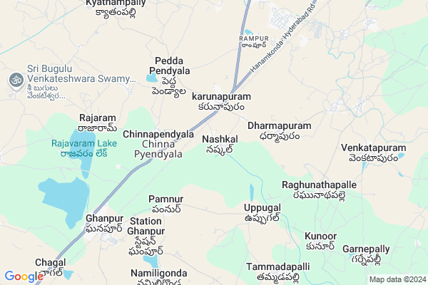
Nashkal
Nashkal Map
EDIT Map
Add Your House
 ..
..
Current Corona Virus Infected Patients Count in Warangal District
| City Name | District Name | Total Covid cases |
|---|---|---|
| Warangal Urban District | Warangal Urban | 23 |
| Mulugu District | Mulugu | 2 |
| Mahabubabad District | Mahabubabad | 1 |
Locality Name :
Nashkal
( నష్కల్ )
Mandal Name : Ghanpur(station)
District : Warangal
State : Telangana
Region : Telangana
Language : Telugu and Urdu
Current Time 03:06 PM
Date: Tuesday , Apr 29,2025 (IST)
Time zone: IST (UTC+5:30)
Elevation / Altitude: 344 meters. Above Seal level
Telephone Code / Std Code: 08711
Assembly constituency : Ghanpur Station assembly constituency
Assembly MLA : Kadiyam Srihari
Lok Sabha constituency : Warangal parliamentary constituency
Parliament MP : DAYAKAR PASUNOORI
Serpanch Name :
Pin Code : 506143
Post Office Name : Ghanpur Station
Commodities Prices : Warangal Market / Mandi
National Highways Reachable To Nashkal
Nationa High Way :NH161AA
Nationa High Way :NH163
Nationa High Way :NH161AA
Nationa High Way :NH163
Rivers Near Nashkal
Kurel Vagu
Kurel Vagu
About Nashkal
Correct below Info and add more info about NashkalNashkal is a Village in Ghanpur(station) Mandal in Warangal District of Telangana State, India. It belongs to Telangana region . It is located 21 KM towards west from District head quarters Warangal. 14 KM from Ghanpur (Stn).
Nashkal Pin code is 506143 and postal head office is Ghanpur Station .
Chinnapendyala ( 3 KM ) , Uppugal ( 4 KM ) , Peddapendyala ( 5 KM ) , Dharmapur ( 5 KM ) , Thatikayala ( 6 KM ) are the nearby Villages to Nashkal. Nashkal is surrounded by Ghanpur(Station) Mandal towards west , Zaffergadh Mandal towards South , Hanamkonda Mandal towards East , Wardhanna Pet Mandal towards East .
Warangal , Jangaon , Siddipet , Karimnagar are the near by Cities to Nashkal.
This Place is in the border of the Warangal District and Karimnagar District. Karimnagar District Bheemdevarapalli is North towards this place .
Nashkal 2011 Census Details
Nashkal Local Language is Telugu. Nashkal Village Total population is 3691 and number of houses are 940. Female Population is 47.9%. Village literacy rate is 58.0% and the Female Literacy rate is 23.5%.
Population
| Census Parameter | Census Data |
| Total Population | 3691 |
| Total No of Houses | 940 |
| Female Population % | 47.9 % ( 1768) |
| Total Literacy rate % | 58.0 % ( 2140) |
| Female Literacy rate | 23.5 % ( 868) |
| Scheduled Tribes Population % | 3.3 % ( 120) |
| Scheduled Caste Population % | 39.6 % ( 1460) |
| Working Population % | 48.0 % |
| Child(0 -6) Population by 2011 | 375 |
| Girl Child(0 -6) Population % by 2011 | 44.0 % ( 165) |
Nashkal Census More Deatils.
Politics in Nashkal
TDP , TRS , INC are the major political parties in this area.Polling Stations /Booths near Nashkal
1)Narayanagiri2)Nashkal
3)Vanaparthy
4)Chinna Pendyala
5)Chinnapendyala
HOW TO REACH Nashkal
By Road
Warangal is the Nearest Town to Nashkal. Warangal is 21 km from Nashkal. Road connectivity is there from Warangal to Nashkal.By Rail
Pindial Rail Way Station , Ghanpur Rail Way Station are the very nearby railway stations to Nashkal. Also you can consider railway Stations from Near By town Warangal. Warangal Rail Way Station , Kazipet Town Rail Way Station are the railway Stations near to Warangal. You can reach from Warangal to Nashkal by road after .Colleges near Nashkal
Govt Juniorcollege
Address :
Schools in Nashkal
Zphs Nashkal
Address : nashkal , ghanpur stn. , warangal , Andhra Pradesh . PIN- 506144 , Post - Abadighanpur
Govt Health Centers near Nashkal
1) SubCentre Nashkal , Nashkal , BC Colony , Near Primary School2) SubCentre Chinnapendyal , Apr-54 , BC Colony , Near Gram pachayat
3) SubCentre, Uppugallu , 4 - 132 , BC Colony , BC Colony
Hospitals in Nashkal,Ghanpur(station)
Sadguru Sri Mallikarjuna Prakruti Ashram
Dharmasagar Mandal; Pedda Pendyala; Telangana 506151; India
4.8 KM distance Detail
more ..
Petrol Bunks in Nashkal,Ghanpur(station)
HP Petrol Pump
SY NO 28/B/E/3; 28/B/E/5; Chinapendyal Village Station; Ghnapure Mandal; Telangana 506144; India
2.6 KM distance Detail
Sri Srinivasa Filling Station Hindustan Petroleum
Karunapuram; Warangal; NH-163; Kajipet Hyderabad Road; Dharma Sagar; Dharma Sagar; Telangana 506151; India
2.6 KM distance Detail
Noble Service Point
Rampur; Warangal; NH-163; Kajipet Hyderabad Road; Kajipet; Kajipet; Telangana 506151; India
3.6 KM distance Detail
Avinash Fuel Resources Hindustan Petroleum
Rampur; Warangal; NH-163; Kajipet Hyderabad Road; Kajipet; Kajipet; Telangana 506151; India
4.8 KM distance Detail
more ..
Electronic Shops in Nashkal,Ghanpur(station)
sai siri enterprese
Hyderabad - Warangal Hwy; karunapuram; Telangana 506144; India
2.2 KM distance Detail
SRI SAI CELL WORLD
Chinnapyendyala to Rajavaram Rd; Chinna Pendyala; Telangana 506144; India
3.2 KM distance Detail
Super Markets in Nashkal,Ghanpur(station)
Ram Narsaiah Kiranam & General Stores
Pedda Pendyala; Telangana 506151; India
4.8 KM distance Detail
Governement Offices near Nashkal,Ghanpur(station)
MeeSeva Center
H.no:16-43;Land mark karnapuram; karnapuram; Dharamasagar; Pedda Pendyala; Telangana 506151; India
2.3 KM distance Detail
MeeSeva Center
Ghanpur(Station) Mandal; Chinna Pendyala; Telangana 506144; India
3.2 KM distance Detail
About Nashkal &
History
How to reach Nashkal
Tourist Places Near By Nashkal
Schools in Nashkal
Colleges in Nashkal
Temperature & weather of Nashkal
places in Nashkal
Nashkal photos
More Information
How to reach Nashkal
Tourist Places Near By Nashkal
Schools in Nashkal
Colleges in Nashkal
Temperature & weather of Nashkal
places in Nashkal
Nashkal photos
More Information
Village Talk
Post News or Events about this Village
Near Cities
Warangal 24 KM near
Jangaon 38 KM near
Siddipet 74 KM near
Karimnagar 78 KM near
Warangal 24 KM near
Jangaon 38 KM near
Siddipet 74 KM near
Karimnagar 78 KM near
Near By Taluks
Dharmasagar 10 KM near
Ghanpur(Station) 13 KM near
Zaffergadh 16 KM near
Hanamkonda 19 KM near
Dharmasagar 10 KM near
Ghanpur(Station) 13 KM near
Zaffergadh 16 KM near
Hanamkonda 19 KM near
Near By Air Ports
Rajiv Gandhi International Airport 143 KM near
Vijayawada Airport 234 KM near
Nanded Airport 296 KM near
Rajahmundry Airport 300 KM near
Rajiv Gandhi International Airport 143 KM near
Vijayawada Airport 234 KM near
Nanded Airport 296 KM near
Rajahmundry Airport 300 KM near
Near By Tourist Places
Warangal 25 KM near
Medaram 110 KM near
Khammam 116 KM near
Hyderabad 128 KM near
Medak 139 KM near
Warangal 25 KM near
Medaram 110 KM near
Khammam 116 KM near
Hyderabad 128 KM near
Medak 139 KM near
Near By Districts
Warangal 21 KM near
Karimnagar 75 KM near
Nalgonda 106 KM near
Khammam 116 KM near
Warangal 21 KM near
Karimnagar 75 KM near
Nalgonda 106 KM near
Khammam 116 KM near
Near By RailWay Station
Pindial Rail Way Station 5.7 KM near
Ghanpur Rail Way Station 8.4 KM near
Kazipet Junction Rail Way Station 14 KM near
Pindial Rail Way Station 5.7 KM near
Ghanpur Rail Way Station 8.4 KM near
Kazipet Junction Rail Way Station 14 KM near