| Home | City Bus | Maps | Villages | Cities | Rail | Tourist Places | School | College | Pin Codes | Corona Cases Count |
| Distance Calculator Bus Services IFSC Codes Trace Mobile Number Weather Search Place Trace IP Available Cash ATM/Banks Locate Polling Booth Report an Error contact People |
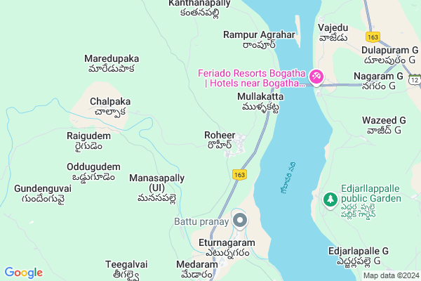
Roheer
Roheer Map
EDIT Map
Add Your House
 ..
..
Current Corona Virus Infected Patients Count in Warangal District
| City Name | District Name | Total Covid cases |
|---|---|---|
| Warangal Urban District | Warangal Urban | 23 |
| Mulugu District | Mulugu | 2 |
| Mahabubabad District | Mahabubabad | 1 |
Locality Name :
Roheer
( రోహీర్ )
Mandal Name : Eturnagaram
District : Warangal
State : Telangana
Region : Telangana
Language : Telugu and Urdu
Current Time 10:37 AM
Date: Friday , Apr 25,2025 (IST)
Time zone: IST (UTC+5:30)
Elevation / Altitude: 92 meters. Above Seal level
Telephone Code / Std Code: 08717
Assembly constituency : Mulug assembly constituency
Assembly MLA : Danasari Anasuya Seethakka
Lok Sabha constituency : Mahabubabad parliamentary constituency
Parliament MP : Kavitha Malothu
Serpanch Name :
Pin Code : 506165
Post Office Name : Eturunagaram
Commodities Prices : Bhopalpattnam Market / Mandi
Edit below overview about Roheer
Edit below overview about Roheer
OverView of Roheer
Roheer is a beautiful village and covered around forest there is a godavari river very cool atmosphereEdit below overview about Roheer
National Highways Reachable To Roheer
Nationa High Way :NH163
Nationa High Way :NH163
Rivers Near Roheer
Are Vagu
Godavari :गोदावरी :ಗೋದಾವರಿ :गोदावरी :கோதாவரி :గోదావరి
Are Vagu
Godavari :गोदावरी :ಗೋದಾವರಿ :गोदावरी :கோதாவரி :గోదావరి
About Roheer
Roheer is a Village in Eturnagaram Mandal in Warangal District of Telangana State, India. It belongs to Telangana region . It is located 117 KM towards East from District head quarters Warangal. 5 KM from Eturnagaram.
Roheer Pin code is 506165 and postal head office is Eturunagaram .
Mullakatta ( 3 KM ) , Ramannagudem ( 5 KM ) , Eturnagaram ( 6 KM ) , Chalpaka ( 6 KM ) , Etur ( 11 KM ) are the nearby Villages to Roheer. Roheer is surrounded by Wazeed Mandal towards North , Venkatapuram Mandal towards East , Mangapet Mandal towards South , Tadvai Mandal towards South .
Manuguru , Yellandu , Bade Bacheli , Bhadrachalam are the near by Cities to Roheer.
This Place is in the border of the Warangal District and Khammam District. Khammam District Venkatapuram is East towards this place .
Roheer 2011 Census Details
Roheer Local Language is Telugu. Roheer Village Total population is 1901 and number of houses are 513. Female Population is 48.8%. Village literacy rate is 44.3% and the Female Literacy rate is 18.3%.
Population
| Census Parameter | Census Data |
| Total Population | 1901 |
| Total No of Houses | 513 |
| Female Population % | 48.8 % ( 927) |
| Total Literacy rate % | 44.3 % ( 843) |
| Female Literacy rate | 18.3 % ( 347) |
| Scheduled Tribes Population % | 8.8 % ( 167) |
| Scheduled Caste Population % | 53.0 % ( 1008) |
| Working Population % | 64.2 % |
| Child(0 -6) Population by 2011 | 259 |
| Girl Child(0 -6) Population % by 2011 | 41.3 % ( 107) |
Roheer Census More Deatils.
Politics in Roheer
TDP , TRS , INC are the major political parties in this area.Polling Stations /Booths near Roheer
1)Rayinigudem2)Sha Palli
3)Shatharajupally H/o Narsapur
4)Mokallapalli
5)Eturunagaram
HOW TO REACH Roheer
By Road
Warangal is the Nearest Town to Roheer. Warangal is 115 km from Roheer. Road connectivity is there from Warangal to Roheer.By Rail
There is no railway station near to Roheer in less than 10 km. How ever there are railway Stations from Near By town Warangal. are the railway Stations near to Warangal. You can reach from Warangal to Roheer by road after .Colleges near Roheer
Aptwr Jr Coll For Boys Eturunagaram
Address : Aptwr Jr Coll For Boys Eturunagaram
Aptwr Jr College For St Girls,eturunagaram
Address : Eturunagaram
Govt Jr College Eturunagaram
Address : Govt Jr College Eturunagaram
Govt. Degree College
Address : Eturunagaram, Warangal
Schools in Roheer
Mpups Roheer
Address : roheer , eturnagaram , warangal , Andhra Pradesh . PIN- 506165 , Post - Eturunagaram
Govt Health Centers near Roheer
1) Primary Health Centre Royyur , , , Near School2) SubCentre Royyur , .4-7 , Ramalayam Street , BC ward
3) SubCentre AK Ghanpur 2 , 7-247 , Teegalavi road , opposite MPDO office
Hospitals in Roheer,Eturnagaram
Sri Venkateswara Clinic.
ups school Road; Shankarajupally; Telangana 506165; India
1.9 KM distance Detail
more ..
Petrol Bunks in Roheer,Eturnagaram
HP PETROL PUMP - SRI SRINIVASA FLG STN KAMALAPURAM
Sy.no.96 B Kamalapuram Village Mangapet Mandal; 506172; India
20.2 KM distance Detail
more ..
Electronic Shops in Roheer,Eturnagaram
SATHISH CELL WORLD
Mangapet Village Road; Mangapet; Narsapur; Telangana 506172; India
21.5 KM distance Detail
Local Parks in Roheer,Eturnagaram
Police Stations near Roheer,Eturnagaram
Mangapet Police Station
Burgampadu Eturnagaram Road; Mangapet; Narsapur; Telangana 506172; India
21.6 KM distance Detail
About Roheer &
History
How to reach Roheer
Tourist Places Near By Roheer
Schools in Roheer
Colleges in Roheer
Temperature & weather of Roheer
places in Roheer
Roheer photos
More Information
How to reach Roheer
Tourist Places Near By Roheer
Schools in Roheer
Colleges in Roheer
Temperature & weather of Roheer
places in Roheer
Roheer photos
More Information
Village Talk
Post News or Events about this Village
Near Cities
Manuguru 73 KM near
Yellandu 99 KM near
Bade Bacheli 105 KM near
Bhadrachalam 106 KM near
Manuguru 73 KM near
Yellandu 99 KM near
Bade Bacheli 105 KM near
Bhadrachalam 106 KM near
Near By Taluks
Eturnagaram 4 KM near
Wazeed 13 KM near
Venkatapuram 23 KM near
Mangapet 28 KM near
Eturnagaram 4 KM near
Wazeed 13 KM near
Venkatapuram 23 KM near
Mangapet 28 KM near
Near By Air Ports
Rajahmundry Airport 230 KM near
Vijayawada Airport 235 KM near
Rajiv Gandhi International Airport 276 KM near
Vishakhapatnam Airport 342 KM near
Rajahmundry Airport 230 KM near
Vijayawada Airport 235 KM near
Rajiv Gandhi International Airport 276 KM near
Vishakhapatnam Airport 342 KM near
Near By Tourist Places
Medaram 22 KM near
Bhadrachalam 105 KM near
Warangal 107 KM near
Dantewada 126 KM near
Bhamragarh Wildlife Sanctuary 128 KM near
Medaram 22 KM near
Bhadrachalam 105 KM near
Warangal 107 KM near
Dantewada 126 KM near
Bhamragarh Wildlife Sanctuary 128 KM near
Near By Districts
Bijapur 68 KM near
Warangal 111 KM near
Dantewada 128 KM near
Khammam 145 KM near
Bijapur 68 KM near
Warangal 111 KM near
Dantewada 128 KM near
Khammam 145 KM near
Near By RailWay Station
Nekonda Rail Way Station 103 KM near
Kesamudram Rail Way Station 107 KM near
Nekonda Rail Way Station 103 KM near
Kesamudram Rail Way Station 107 KM near