| Home | City Bus | Maps | Villages | Cities | Rail | Tourist Places | School | College | Pin Codes | Corona Cases Count |
| Distance Calculator Bus Services IFSC Codes Trace Mobile Number Weather Search Place Trace IP Available Cash ATM/Banks Locate Polling Booth Report an Error contact People |
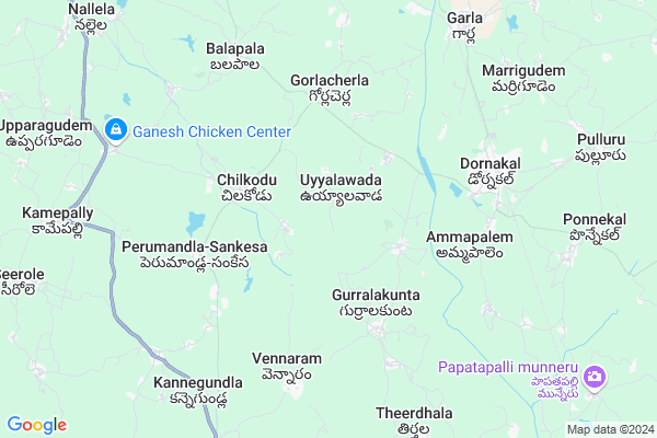
Sadu Thanda Map
EDIT Map
Add Your House
 ..
..
Current Corona Virus Infected Patients Count in Warangal District
| City Name | District Name | Total Covid cases |
|---|---|---|
| Warangal Urban District | Warangal Urban | 23 |
| Mulugu District | Mulugu | 2 |
| Mahabubabad District | Mahabubabad | 1 |
Locality Name :
Sadu Thanda
( సాడు తండా )
Mandal Name : Dornakal
District : Warangal
State : Telangana
Region : Telangana
Language : Telugu and Urdu
Current Time 12:31 AM
Date: Wednesday , Apr 30,2025 (IST)
Time zone: IST (UTC+5:30)
Elevation / Altitude: 153 meters. Above Seal level
Telephone Code / Std Code: 08719
Assembly constituency : Dornakal assembly constituency
Assembly MLA : Jatoth Ram Chander Naik
Lok Sabha constituency : Mahabubabad parliamentary constituency
Parliament MP : Kavitha Malothu
Serpanch Name :
Main Village Name : Mannegudem
Commodities Prices : Khammam Market / Mandi
Sadu Thanda Live Weather
Temperature: 29.6 °C
clear sky
Humidity: 58%
Wind : 5.5 mt/sec towards S
StationName : "Dornakal"
observed on 5 Mins Back
Temperature: 29.6 °C
clear sky
Humidity: 58%
Wind : 5.5 mt/sec towards S
StationName : "Dornakal"
observed on 5 Mins Back
Sadu Thanda Weather Forecast for Next 5 days
30-04-2025
28.2°C to 29.9°C
clear sky
28.2°C to 29.9°C
clear sky
01-05-2025
27.0°C to 41.0°C
clear sky, broken clouds, scattered clouds, few clouds, overcast clouds
27.0°C to 41.0°C
clear sky, broken clouds, scattered clouds, few clouds, overcast clouds
02-05-2025
27.1°C to 40.7°C
scattered clouds, few clouds, clear sky
27.1°C to 40.7°C
scattered clouds, few clouds, clear sky
03-05-2025
27.4°C to 41.7°C
few clouds, broken clouds, scattered clouds, clear sky
27.4°C to 41.7°C
few clouds, broken clouds, scattered clouds, clear sky
04-05-2025
27.3°C to 41.9°C
few clouds, clear sky, moderate rain, light rain, scattered clouds, broken clouds
27.3°C to 41.9°C
few clouds, clear sky, moderate rain, light rain, scattered clouds, broken clouds
National Highways Reachable To Sadu Thanda
Nationa High Way :NH38
Nationa High Way :NH563
Nationa High Way :NH38
Nationa High Way :NH563
Rivers Near Sadu Thanda
Pedda Vagu
Ken
Pedda Vagu
Ken
About Sadu Thanda
Correct below Info and add more info about Sadu ThandaSadu Thanda is a small Village/hamlet in Dornakal Mandal in Warangal District of Telangana State, India. It comes under Mannegudem Panchayath. It belongs to Telangana region . It is located 96 KM towards South from District head quarters Warangal.
Sadu Thanda is surrounded by Garla Mandal towards North , Kuravi Mandal towards west , Kamepally Mandal towards East , Khammam (Rural) Mandal towards South .
Khammam , Yellandu , Palwancha , Kodad are the near by Cities to Sadu Thanda.
This Place is in the border of the Warangal District and Khammam District. Khammam District Garla is North towards this place .
Demographics of Sadu Thanda
Telugu is the Local Language here. Total population of Sadu Thanda is 6532 .Males are 3303 and Females are 3,229 living in 1469 Houses. Total area of Sadu Thanda is 2022 hectares.Politics in Sadu Thanda
TDP , TRS , INC are the major political parties in this area.Polling Stations /Booths near Sadu Thanda
1)Pagidipelly H/o Chinnagudur2)Burhanpur
3)Upperagudem
4)Uyyalawada
5)Burugupadu
HOW TO REACH Sadu Thanda
By Road
Warangal is the Nearest Town to Sadu Thanda. Warangal is 123 km from Sadu Thanda. Road connectivity is there from Warangal to Sadu Thanda.By Rail
Dornakal Junction Rail Way Station , Garla Rail Way Station are the very nearby railway stations to Sadu Thanda. Also you can consider railway Stations from Near By town Warangal. Warangal Rail Way Station , Kazipet Town Rail Way Station are the railway Stations near to Warangal. You can reach from Warangal to Sadu Thanda by road after .Pincodes near Sadu Thanda
506381 ( Dornakal ) , 507210 ( Garla ) , 507003 ( Trunk Road (Khammam) )Colleges near Sadu Thanda
D D Jr College? Dornakal
Address : D D Jr College? Dornakal
Bishop Azaraiah Degree College
Address : Dornakal, Warangal Dist.,
Schools in Sadu Thanda
Mpups Chilakoyalapadu
Address : mannegudem , dornakal , warangal , Andhra Pradesh . PIN- 506105 , Post - Kuravi
Mpups Mannegudem
Address : mannegudem , dornakal , warangal , Andhra Pradesh . PIN- 506381 , Post - Dornakal
Govt Health Centers near Sadu Thanda
1) SubCentre Uyyalawada , , Mainroad , S.C colony2) SubCentre Chilukonda , 3/29/2009 , Burugupad Road , Burugupad Road
3) SubCentre Gollacherla I , , Main Road , Main Road
Governement Offices near Sadu Thanda,Dornakal
Grama Panchayathi Office
Uyyalawada;Dornakal;Warangal; Golla Gudem; 506381; India
2.9 KM distance Detail
About Sadu Thanda &
History
How to reach Sadu Thanda
Tourist Places Near By Sadu Thanda
Schools in Sadu Thanda
Colleges in Sadu Thanda
Temperature & weather of Sadu Thanda
places in Sadu Thanda
Sadu Thanda photos
More Information
How to reach Sadu Thanda
Tourist Places Near By Sadu Thanda
Schools in Sadu Thanda
Colleges in Sadu Thanda
Temperature & weather of Sadu Thanda
places in Sadu Thanda
Sadu Thanda photos
More Information
Village Talk
Post News or Events about this Village
Near Cities
Khammam 23 KM near
Yellandu 33 KM near
Palwancha 39 KM near
Kodad 54 KM near
Khammam 23 KM near
Yellandu 33 KM near
Palwancha 39 KM near
Kodad 54 KM near
Near By Taluks
Dornakal 0 KM near
Garla 9 KM near
Kuravi 15 KM near
Kamepally 19 KM near
Dornakal 0 KM near
Garla 9 KM near
Kuravi 15 KM near
Kamepally 19 KM near
Near By Air Ports
Vijayawada Airport 139 KM near
Rajiv Gandhi International Airport 200 KM near
Rajahmundry Airport 208 KM near
Vishakhapatnam Airport 373 KM near
Vijayawada Airport 139 KM near
Rajiv Gandhi International Airport 200 KM near
Rajahmundry Airport 208 KM near
Vishakhapatnam Airport 373 KM near
Near By Tourist Places
Khammam 23 KM near
Warangal 91 KM near
Nagarjunakonda 92 KM near
Bhadrachalam 98 KM near
Amaravathi 112 KM near
Khammam 23 KM near
Warangal 91 KM near
Nagarjunakonda 92 KM near
Bhadrachalam 98 KM near
Amaravathi 112 KM near
Near By Districts
Khammam 23 KM near
Warangal 92 KM near
Nalgonda 110 KM near
Guntur 146 KM near
Khammam 23 KM near
Warangal 92 KM near
Nalgonda 110 KM near
Guntur 146 KM near
Near By RailWay Station
Dornakal Junction Rail Way Station 6.9 KM near
Garla Rail Way Station 8.9 KM near
Khammam Rail Way Station 23 KM near
Dornakal Junction Rail Way Station 6.9 KM near
Garla Rail Way Station 8.9 KM near
Khammam Rail Way Station 23 KM near