| Home | City Bus | Maps | Villages | Cities | Rail | Tourist Places | School | College | Pin Codes | Corona Cases Count |
| Distance Calculator Bus Services IFSC Codes Trace Mobile Number Weather Search Place Trace IP Available Cash ATM/Banks Locate Polling Booth Report an Error contact People |
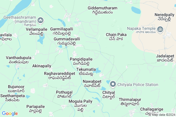
Kothapet Map
EDIT Map
Add Your House
 ..
..
Current Corona Virus Infected Patients Count in Warangal District
| City Name | District Name | Total Covid cases |
|---|---|---|
| Warangal Urban District | Warangal Urban | 23 |
| Mulugu District | Mulugu | 2 |
| Mahabubabad District | Mahabubabad | 1 |
Locality Name :
Kothapet
( కొత్తపేట )
Mandal Name : Chityal
District : Warangal
State : Telangana
Region : Telangana
Language : Telugu and Urdu
Current Time 04:32 AM
Date: Saturday , Apr 26,2025 (IST)
Time zone: IST (UTC+5:30)
Elevation / Altitude: 227 meters. Above Seal level
Telephone Code / Std Code: 08713
Assembly constituency : Bhupalpalle assembly constituency
Assembly MLA : Gandra Satyanarayana Rao
Lok Sabha constituency : Warangal parliamentary constituency
Parliament MP : DAYAKAR PASUNOORI
Serpanch Name :
Main Village Name : Vodethala
Commodities Prices : Parkal Market / Mandi
Kothapet Live Weather
Temperature: 32.8 °C
broken clouds
Humidity: 35%
Wind : 4.96 mt/sec towards S
StationName : "Manthani"
observed on 1 Hours Back
Temperature: 32.8 °C
broken clouds
Humidity: 35%
Wind : 4.96 mt/sec towards S
StationName : "Manthani"
observed on 1 Hours Back
Kothapet Weather Forecast for Next 5 days
27-04-2025
30.1°C to 40.4°C
broken clouds, clear sky, scattered clouds, light rain, overcast clouds
30.1°C to 40.4°C
broken clouds, clear sky, scattered clouds, light rain, overcast clouds
28-04-2025
26.3°C to 39.1°C
overcast clouds, broken clouds, light rain, moderate rain, clear sky
26.3°C to 39.1°C
overcast clouds, broken clouds, light rain, moderate rain, clear sky
29-04-2025
26.7°C to 40.6°C
clear sky
26.7°C to 40.6°C
clear sky
30-04-2025
27.2°C to 41.7°C
clear sky, few clouds, scattered clouds
27.2°C to 41.7°C
clear sky, few clouds, scattered clouds
National Highways Reachable To Kothapet
Nationa High Way :NH563
Nationa High Way :NH563
Rivers Near Kothapet
Are Vagu
Sali Vagu
Are Vagu
Sali Vagu
About Kothapet
Correct below Info and add more info about KothapetKothapet is a small Village/hamlet in Chityal Mandal in Warangal District of Telangana State, India. It comes under Vodethala Panchayath. It belongs to Telangana region . As part Telangana Districts re-organisation , Kothapet Village Chityal Mandal re organised from Warangal District to Nalgonda,Jaya Shankar district. It is located 51 KM towards North from District head quarters Warangal.
Kothapet is surrounded by Mogullapalle Mandal towards South , Jammikunta Mandal towards west , Srirampur Mandal towards North , Odela Mandal towards west .
Warangal , Ramagundam , Karimnagar , Mancherial are the near by Cities to Kothapet.
Demographics of Kothapet
Telugu is the Local Language here.Politics in Kothapet
TRS , INC are the major political parties in this area.Polling Stations /Booths near Kothapet
1)Singaram (kothagattu)2)Ramakishtapur (v)
3)Taharapur (mandaripeta)
4)Tekumatla
5)Tekumatla
HOW TO REACH Kothapet
By Rail
There is no railway station near to Kothapet in less than 10 km. Warangal Rail Way Station (near to Warangal) , Kazipet Town Rail Way Station (near to Warangal) are the Rail way stations reachable from near by towns.By Road
Warangal are the nearby by towns to Kothapet having road connectivity to KothapetPincodes near Kothapet
506356 ( Chityal ) , 506366 ( Mogullapalli ) , 505475 ( Vavilala )Colleges near Kothapet
Vaagdevi Junior Colkege
Address :
Schools near Kothapet
Kgbv Chityal
Address : chityal , chityal , warangal , Andhra Pradesh . PIN- 506356 , Post - Chityal
Sri Vivekananda Puahs
Address : vodthala , chityal , warangal , Andhra Pradesh . PIN- 506348 , Post - Regonda
Zphs Venkat Rao Pally
Address : venkatraopalle , chityal , warangal , Andhra Pradesh . PIN- 506356 , Post - Chityal
S V Kethan Puahs
Address : jadalapet , chityal , warangal , Andhra Pradesh . PIN- 506356 , Post - Chityal
Govt Health Centers near Kothapet
1) SubCentre Tekumatla , 2/4/1966 , S.c colony , S.c colony2) SubCentre, Nawabpet , May-88 , BC.COLONY , NEAR GP
3) SubCentre, Rangareddypeta , Raghavareddypet , Tekumatla Road , Near Govt School
Colleges in Kothapet,Chityal
GOVERNMENT JUNIOR COLLEGE.
NEAR BUSTAND; Warangal - Eturnagaram Rd; Eturnagaram; Telangana 506344; India
5.9 KM distance Detail
more ..
Electronic Shops in Kothapet,Chityal
PAVAN AUTOMOBILES & OILS
Garmillapally Road; Tekumatla; Jayashnkar; Telangana Dist; India
2.7 KM distance Detail
About Kothapet &
History
How to reach Kothapet
Tourist Places Near By Kothapet
Schools in Kothapet
Colleges in Kothapet
Temperature & weather of Kothapet
places in Kothapet
Kothapet photos
More Information
How to reach Kothapet
Tourist Places Near By Kothapet
Schools in Kothapet
Colleges in Kothapet
Temperature & weather of Kothapet
places in Kothapet
Kothapet photos
More Information
Village Talk
Post News or Events about this Village
Near Cities
Warangal 45 KM near
Ramagundam 53 KM near
Karimnagar 64 KM near
Mancherial 66 KM near
Warangal 45 KM near
Ramagundam 53 KM near
Karimnagar 64 KM near
Mancherial 66 KM near
Near By Taluks
Chityal 0 KM near
Mogullapalle 9 KM near
Jammikunta 18 KM near
Parkal 21 KM near
Chityal 0 KM near
Mogullapalle 9 KM near
Jammikunta 18 KM near
Parkal 21 KM near
Near By Air Ports
Rajiv Gandhi International Airport 201 KM near
Vijayawada Airport 266 KM near
Nanded Airport 293 KM near
Rajahmundry Airport 301 KM near
Rajiv Gandhi International Airport 201 KM near
Vijayawada Airport 266 KM near
Nanded Airport 293 KM near
Rajahmundry Airport 301 KM near
Near By Tourist Places
Warangal 46 KM near
Medaram 70 KM near
Sirpur 138 KM near
Khammam 151 KM near
Medak 168 KM near
Warangal 46 KM near
Medaram 70 KM near
Sirpur 138 KM near
Khammam 151 KM near
Medak 168 KM near
Near By Districts
Warangal 48 KM near
Karimnagar 61 KM near
Bijapur 147 KM near
Khammam 151 KM near
Warangal 48 KM near
Karimnagar 61 KM near
Bijapur 147 KM near
Khammam 151 KM near
Near By RailWay Station
Jammikunta Rail Way Station 22 KM near
Peddapalli Junction Rail Way Station 42 KM near
Jammikunta Rail Way Station 22 KM near
Peddapalli Junction Rail Way Station 42 KM near