| Home | City Bus | Maps | Villages | Cities | Rail | Tourist Places | School | College | Pin Codes | Corona Cases Count |
| Distance Calculator Bus Services IFSC Codes Trace Mobile Number Weather Search Place Trace IP Available Cash ATM/Banks Locate Polling Booth Report an Error contact People |
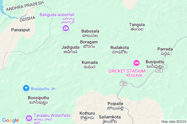
Kumada
Kumada Map
EDIT Map
Add Your House
 ..
..
Current Corona Virus Infected Patients Count in Visakhapatanam District
| City Name | District Name | Total Covid cases |
|---|---|---|
| Visakhapatnam District | Visakhapatnam | 14 |
| Visakhapatnam | Visakhapatnam | 2 |
| Akkayyapelem | Visakhapatnam | 2 |
| Narsipatnam | Visakhapatnam | 2 |
| Visakapatnam | Visakhapatnam | 1 |
| Gajuwaka | Visakhapatnam | 1 |
Locality Name :
Kumada
( కుముద )
Mandal Name : Munchingi Puttu
District : Visakhapatanam
State : Andhra Pradesh
Region : Andhra
Language : Telugu
Current Time 10:07 AM
Date: Thursday , Apr 24,2025 (IST)
Time zone: IST (UTC+5:30)
Elevation / Altitude: 910 meters. Above Seal level
Telephone Code / Std Code: 08935
Assembly constituency : Alur assembly constituency
Assembly MLA : P Jayaram
Lok Sabha constituency : Kurnool parliamentary constituency
Parliament MP : AYUSHMAN DOCTOR SANJEEV KUMAR
Serpanch Name :
Pin Code : 531040
Post Office Name : Pedabayalu
Commodities Prices : Malkanagiri Market / Mandi
Rivers Near Kumada
Sileru
Sileru
Sileru
Sileru
About Kumada
Correct below Info and add more info about KumadaKumada is a Village in Munchingi Puttu Mandal in Visakhapatanam District of Andhra Pradesh State, India. It belongs to Andhra region . It is located 122 KM towards west from District head quarters Vishakhapatnam. 13 KM from Munchingi Puttu. 502 KM from State capital Hyderabad
Kumada Pin code is 531040 and postal head office is Pedabayalu .
Rudakota ( 4 KM ) , Poipalle ( 6 KM ) , Busiputtu ( 7 KM ) , Jarjula ( 10 KM ) , Parreda ( 10 KM ) are the nearby Villages to Kumada. Kumada is surrounded by Munchingi Puttu Mandal towards North , Kudumulugumma Mandal towards west , Khairaput Mandal towards North , G.Madugula Mandal towards South .
Malkangiri , Sunabeda , Jeypur , Koraput are the near by Cities to Kumada.
Kumada 2011 Census Details
Kumada Local Language is Telugu. Kumada Village Total population is 311 and number of houses are 95. Female Population is 54.0%. Village literacy rate is 37.9% and the Female Literacy rate is 11.6%.
Population
| Census Parameter | Census Data |
| Total Population | 311 |
| Total No of Houses | 95 |
| Female Population % | 54.0 % ( 168) |
| Total Literacy rate % | 37.9 % ( 118) |
| Female Literacy rate | 11.6 % ( 36) |
| Scheduled Tribes Population % | 97.7 % ( 304) |
| Scheduled Caste Population % | 0.0 % ( 0) |
| Working Population % | 68.2 % |
| Child(0 -6) Population by 2011 | 40 |
| Girl Child(0 -6) Population % by 2011 | 65.0 % ( 26) |
Kumada Census More Deatils.
Politics in Kumada
TDP , YSRC , Yuvajana Sramika Rythu Congress Party , PRAP , YSRCP , INC are the major political parties in this area.Polling Stations /Booths near Kumada
1)M.kottala2)Nitravatti
3)P.kotakonda
4)P.kotakonda-
5)P.kotakonda-
HOW TO REACH Kumada
By Road
Visakhapatnam is the Nearest Town to Kumada. Visakhapatnam is 181 km from Kumada. Road connectivity is there from Visakhapatnam to Kumada.By Rail
There is no railway station near to Kumada in less than 10 km. How ever there are railway Stations from Near By town Visakhapatnam. are the railway Stations near to Visakhapatnam. You can reach from Visakhapatnam to Kumada by road after .By Bus
G.Madugula APSRTC Bus Station , Paderu APSRTC Bus Station , Chintapally APSRTC Bus Station are the nearby by Bus Stations to Kumada .APSRTC runs Number of busses from major cities to here.Colleges near Kumada
Dadi Satyanarayana College Of Eduation, (b.ed.,) , Anakapalle
Address :
Sabbavarapu Pandu Ranga Kumar Degree Collage
Address :
Govt College
Address :
Sri Gnaneswari Engineering College For Women
Address :
Sri Sai Rsn Jr College
Address :
Schools in Kumada
Mpups Kumada
Address : kumada , munchingput , visakhapatnam , Andhra Pradesh . PIN- 531040 , Post - Pedabayalu
Govt Health Centers near Kumada
1) E.Kumada , Government sub center , E KUMADA , MPUP SCHOOL2) Madhulabanda , GOVERNMENT , Madhulabanda , Panthyat office
3) Bangarumetta , Government sub center , kujabangi road , BANGARUMETTA
Sub Villages in Kumada
Schools in Kumada,Munchingi Puttu
Electronic Shops in Kumada,Munchingi Puttu
Super Markets in Kumada,Munchingi Puttu
Local Parks in Kumada,Munchingi Puttu
Police Stations near Kumada,Munchingi Puttu
Governement Offices near Kumada,Munchingi Puttu
About Kumada &
History
How to reach Kumada
Tourist Places Near By Kumada
Schools in Kumada
Colleges in Kumada
Temperature & weather of Kumada
places in Kumada
Kumada photos
More Information
How to reach Kumada
Tourist Places Near By Kumada
Schools in Kumada
Colleges in Kumada
Temperature & weather of Kumada
places in Kumada
Kumada photos
More Information
Village Talk
Post News or Events about this Village
Near Cities
Malkangiri 64 KM near
Sunabeda 73 KM near
Jeypur 75 KM near
Koraput 75 KM near
Malkangiri 64 KM near
Sunabeda 73 KM near
Jeypur 75 KM near
Koraput 75 KM near
Near By Taluks
Peda Bayalu 12 KM near
Munchingi Puttu 12 KM near
Kudumulugumma 27 KM near
Khairaput 31 KM near
Peda Bayalu 12 KM near
Munchingi Puttu 12 KM near
Kudumulugumma 27 KM near
Khairaput 31 KM near
Near By Air Ports
Vishakhapatnam Airport 115 KM near
Rajahmundry Airport 162 KM near
Vijayawada Airport 291 KM near
Raipur Airport 372 KM near
Vishakhapatnam Airport 115 KM near
Rajahmundry Airport 162 KM near
Vijayawada Airport 291 KM near
Raipur Airport 372 KM near
Near By Tourist Places
Ananthagiri 51 KM near
Araku Valley 51 KM near
Jeypore 75 KM near
Jagdalpur 112 KM near
Simhachalam 114 KM near
Ananthagiri 51 KM near
Araku Valley 51 KM near
Jeypore 75 KM near
Jagdalpur 112 KM near
Simhachalam 114 KM near
Near By Districts
Malkangiri 65 KM near
Koraput 74 KM near
Vizianagaram 116 KM near
Visakhapatanam 117 KM near
Malkangiri 65 KM near
Koraput 74 KM near
Vizianagaram 116 KM near
Visakhapatanam 117 KM near
Near By RailWay Station
Koraput Junction Rail Way Station 72 KM near
Anakapalle Rail Way Station 98 KM near
Koraput Junction Rail Way Station 72 KM near
Anakapalle Rail Way Station 98 KM near