| Home | City Bus | Maps | Villages | Cities | Rail | Tourist Places | School | College | Pin Codes | Corona Cases Count |
| Distance Calculator Bus Services IFSC Codes Trace Mobile Number Weather Search Place Trace IP Available Cash ATM/Banks Locate Polling Booth Report an Error contact People |
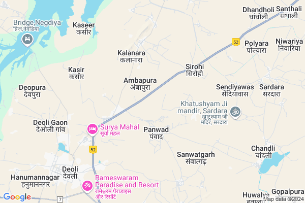
Panwar Map
EDIT Map
Add Your House
 ..
..
Current Corona Virus Infected Patients Count in Tonk District
| City Name | District Name | Total Covid cases |
|---|---|---|
| Tonk District | Tonk | 115 |
Locality Name :
Panwar
( पंवार )
Tehsil Name : Deoli
District : Tonk
State : Rajasthan
Division : Ajmer
Language : Hindi and Rajasthani
Current Time 11:15 AM
Date: Tuesday , Apr 29,2025 (IST)
Time zone: IST (UTC+5:30)
Elevation / Altitude: 256 meters. Above Seal level
Telephone Code / Std Code: 01434
Assembly constituency : Deoli-Uniara assembly constituency
Assembly MLA : Harish Chandra Meena
Lok Sabha constituency : Tonk-Sawai Madhopur parliamentary constituency
Parliament MP : Sukhbir Singh Jaunapuria
Serpanch Name :
Pin Code : 304803
Post Office Name : Panwar
Commodities Prices : Deoli Market / Mandi
Rivers Near Panwar
Para Kala
Banas
Para Kala
Banas
About Panwar
Correct below Info and add more info about PanwarPanwar is a Village in Deoli Tehsil in Tonk District of Rajasthan State, India. It belongs to Ajmer Division . It is located 64 KM towards South from District head quarters Tonk. 11 KM from Deoli Gaon. 151 KM from State capital Jaipur
Panwar Pin code is 304803 and postal head office is Panwar .
Kaseer ( 7 KM ) , Deoli Gaon ( 8 KM ) , Polyara ( 9 KM ) , Rajmahal ( 11 KM ) , Santhali ( 12 KM ) are the nearby Villages to Panwar. Panwar is surrounded by Kekri Tehsil towards west , Hindoli Tehsil towards South , Todaraisingh Tehsil towards North , Jahazpur Tehsil towards South .
Todaraisingh , Tonk , Shahpura , Malpura are the near by Cities to Panwar.
This Place is in the border of the Tonk District and Ajmer District. Ajmer District Kekri is west towards this place .
Panwar 2011 Census Details
Panwar Local Language is Hindi. Panwar Village Total population is 4352 and number of houses are 912. Female Population is 48.7%. Village literacy rate is 59.1% and the Female Literacy rate is 23.0%.
Population
| Census Parameter | Census Data |
| Total Population | 4352 |
| Total No of Houses | 912 |
| Female Population % | 48.7 % ( 2118) |
| Total Literacy rate % | 59.1 % ( 2573) |
| Female Literacy rate | 23.0 % ( 1001) |
| Scheduled Tribes Population % | 2.0 % ( 87) |
| Scheduled Caste Population % | 28.2 % ( 1229) |
| Working Population % | 62.6 % |
| Child(0 -6) Population by 2011 | 635 |
| Girl Child(0 -6) Population % by 2011 | 45.2 % ( 287) |
Panwar Census More Deatils.
Polling Stations /Booths near Panwar
1)Govt Primery School Deoli City No.22)Gov Middle School Sendiyawas
3)Govt Sec School Gairoli Right Part
4)Panchayat Bhawan Chouru
5)Gov Middle School Dabla
HOW TO REACH Panwar
By Rail
There is no railway station near to Panwar in less than 10 km.Colleges near Panwar
Govt. College, Deoli, Tonk
Address :
Maharshi Kashyap College
Address :
Krishna Mahila Mahavidyalaya
Address :
Govt. Collage Deoli
Address : Deoli
मयूर जमना देवी कॉलेज Nasirda टोंक
Address : Nasirda
Schools near Panwar
Bharitiya Pub. Sec. Sch. Nagarfort
Address : nagarfort , deoli , tonk , Rajasthan . PIN- 304024 , Post - Uniara
Ups Neharu Bal Ni. Juniya
Address : juniya , deoli , tonk , Rajasthan . PIN- 304802 , Post - Duni (Tonk)
Maa Bharti V.m. Ambapura
Address : ambapura (ganwadi) , deoli , tonk , Rajasthan . PIN- 304804 , Post - Deoli (Tonk)
Rajan Rajiv Vidhya Dhunwa Kalan
Address : dhuan kalan , deoli , tonk , Rajasthan . PIN- 304806
Govt Health Centers near Panwar
1) Ambapura , VILLAGE AMBAPURA , ,2) Panwar , VILLAGE PANWAR , ,
3) Raghunath Pura , VILLAGE RAGHUNATHPURA , ,
Hospitals in Panwar,Deoli
Primary Health Center
Barani; Bundi; NH-12; Kota Road; Bundi; Bundi; Rajasthan 304804; India
14.6 KM distance Detail
more ..
Petrol Bunks in Panwar,Deoli
Reliance Petroleum
NH12; MILE STONE 155; VILL; TALUKA; Panwad Rd; Deoli; Rajasthan 304804; India
2.5 KM distance Detail
ESSAR PETROL PUMP (KAMDAR SAHAB FILLING STATION)
BISALPUR ROAD; Deoli; Rajasthan 304804; India
2.6 KM distance Detail
HP PETROL PUMP - MUNDRA PETROLEUM
Sirohi Tonk; NH 12; Kota; Rajasthan 304804; India
4.9 KM distance Detail
more ..
Schools in Panwar,Deoli
Jai Hind Coching Deoli Tonk
Madhosinghpura at Daulta; Rajasthan 304804; India
0.7 KM distance Detail
Jai Hind Difesh Coching Center Deoli
Madhosinghpura at Daulta; Rajasthan 304804; India
0.8 KM distance Detail
Swami Vivekananda Model School; Panwad ; Deoli
Madhosinghpura at Daulta; Rajasthan 304804; India
2.0 KM distance Detail
Governement Offices near Panwar,Deoli
Public Health Engineering Department (Water Works); Dooni
MDR 94; Dooni; Rajasthan 304802; India
20.8 KM distance Detail
About Panwar &
History
How to reach Panwar
Tourist Places Near By Panwar
Schools in Panwar
Colleges in Panwar
Temperature & weather of Panwar
places in Panwar
Panwar photos
More Information
How to reach Panwar
Tourist Places Near By Panwar
Schools in Panwar
Colleges in Panwar
Temperature & weather of Panwar
places in Panwar
Panwar photos
More Information
Village Talk
Post News or Events about this Village
Near Cities
Todaraisingh 30 KM near
Tonk 60 KM near
Shahpura 61 KM near
Malpura 62 KM near
Todaraisingh 30 KM near
Tonk 60 KM near
Shahpura 61 KM near
Malpura 62 KM near
Near By Taluks
Deoli 10 KM near
Kekri 26 KM near
Hindoli 33 KM near
Todaraisingh 36 KM near
Deoli 10 KM near
Kekri 26 KM near
Hindoli 33 KM near
Todaraisingh 36 KM near
Near By Air Ports
Sanganeer Airport 133 KM near
Dabok Airport 228 KM near
Jodhpur Airport 273 KM near
Gwalior Airport 318 KM near
Sanganeer Airport 133 KM near
Dabok Airport 228 KM near
Jodhpur Airport 273 KM near
Gwalior Airport 318 KM near
Near By Tourist Places
Bundi 50 KM near
Bijolia 80 KM near
Kota 89 KM near
Sawai Madhopur 106 KM near
Bhilwara 106 KM near
Bundi 50 KM near
Bijolia 80 KM near
Kota 89 KM near
Sawai Madhopur 106 KM near
Bhilwara 106 KM near
Near By Districts
Bundi 51 KM near
Tonk 61 KM near
Kota 89 KM near
Bhilwara 106 KM near
Bundi 51 KM near
Tonk 61 KM near
Kota 89 KM near
Bhilwara 106 KM near
Near By RailWay Station
Bundi Rail Way Station 54 KM near
Keshorai Patan Rail Way Station 81 KM near
Bundi Rail Way Station 54 KM near
Keshorai Patan Rail Way Station 81 KM near