| Home | City Bus | Maps | Villages | Cities | Rail | Tourist Places | School | College | Pin Codes | Corona Cases Count |
| Distance Calculator Bus Services IFSC Codes Trace Mobile Number Weather Search Place Trace IP Available Cash ATM/Banks Locate Polling Booth Report an Error contact People |
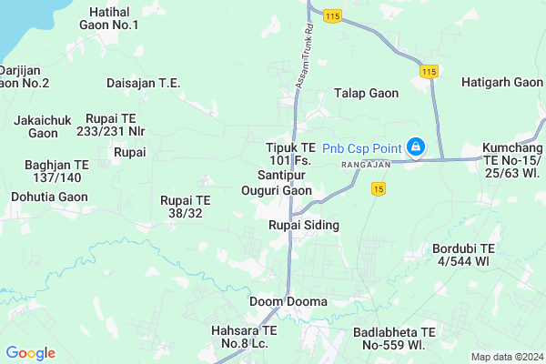
Tipuk Map
EDIT Map
Add Your House
 ..
..
Current Corona Virus Infected Patients Count in Tinsukia District
| City Name | District Name | Total Covid cases |
|---|
Locality Name :
Tipuk
( तिपुक )
Tehsil Name : Hapjan
District : Tinsukia
State : Assam
Language : Assamese and Bengali
Current Time 07:03 AM
Date: Saturday , Apr 26,2025 (IST)
Time zone: IST (UTC+5:30)
Elevation / Altitude: 130 meters. Above Seal level
Telephone Code / Std Code: 0374
Assembly constituency : Doom Dooma assembly constituency
Assembly MLA : Rupesh Gowala
Lok Sabha constituency : Lakhimpur parliamentary constituency
Parliament MP : PRADAN BARUAH
Serpanch Name :
Tipuk Live Weather
Temperature: 22.7 °C
few clouds
Humidity: 74%
Wind : 3.97 mt/sec towards NE
StationName : "Dum Duma"
observed on Now
Temperature: 22.7 °C
few clouds
Humidity: 74%
Wind : 3.97 mt/sec towards NE
StationName : "Dum Duma"
observed on Now
Tipuk Weather Forecast for Next 5 days
27-04-2025
20.4°C to 28.8°C
light rain, clear sky, scattered clouds, broken clouds
20.4°C to 28.8°C
light rain, clear sky, scattered clouds, broken clouds
28-04-2025
20.7°C to 29.7°C
broken clouds, light rain, few clouds
20.7°C to 29.7°C
broken clouds, light rain, few clouds
29-04-2025
20.7°C to 26.1°C
light rain, overcast clouds
20.7°C to 26.1°C
light rain, overcast clouds
30-04-2025
19.6°C to 23.9°C
overcast clouds, broken clouds
19.6°C to 23.9°C
overcast clouds, broken clouds
01-05-2025
20.0°C to 23.1°C
overcast clouds, light rain
20.0°C to 23.1°C
overcast clouds, light rain
National Highways Reachable To Tipuk
Nationa High Way :NH315A
Nationa High Way :NH115
Nationa High Way :NH315A
Nationa High Way :NH115
Rivers Near Tipuk
Dikari
Lohit
Dikari
Lohit
About Tipuk
Correct below Info and add more info about TipukTipuk is a Village in Hapjan Tehsil in Tinsukia District of Assam State, India. It is located 26 KM towards East from District head quarters Tinsukia. 11 KM from Hapjan. 482 KM from State capital Dispur
Rangajan ( 3 KM ) , Dangari ( 7 KM ) , Talap ( 8 KM ) , Bordubi ( 10 KM ) , Samdang ( 11 KM ) are the nearby Villages to Tipuk. Tipuk is surrounded by Kakopathar Tehsil towards East , Saikhowa Tehsil towards west , Guijan Tehsil towards west , Tinsukia Tehsil towards west .
Tinsukia , Digboi , Duliajan Oil Town , Margherita are the near by Cities to Tipuk.
Tipuk T.E. 101 Fs. 2011 Census Details
Tipuk Local Language is Assamese. Tipuk T.E. 101 Fs. Village Total population is 1973 and number of houses are 404. Female Population is 48.7%. Village literacy rate is 52.5% and the Female Literacy rate is 23.4%.
Population
| Census Parameter | Census Data |
| Total Population | 1973 |
| Total No of Houses | 404 |
| Female Population % | 48.7 % ( 960) |
| Total Literacy rate % | 52.5 % ( 1035) |
| Female Literacy rate | 23.4 % ( 462) |
| Scheduled Tribes Population % | 5.2 % ( 103) |
| Scheduled Caste Population % | 0.0 % ( 0) |
| Working Population % | 49.6 % |
| Child(0 -6) Population by 2011 | 296 |
| Girl Child(0 -6) Population % by 2011 | 45.6 % ( 135) |
Tipuk T.E. 101 Fs. Census More Deatils.
Politics in Tipuk
Bharatiya Janata Party , 50646 , 83.58% , INC are the major political parties in this area.Polling Stations /Booths near Tipuk
1)Roborguri Lp School2)Rupai Lp School (right)
3)Rupai Me School (left)
4)No.2 Nagaon Lp School
5)Rupai High School
HOW TO REACH Tipuk
By Rail
There is no railway station near to Tipuk in less than 10 km.Pincodes near Tipuk
786153 ( Rupaisiding ) , 786156 ( Talap (Tinsukia) ) , 786151 ( Netaji Road )Colleges near Tipuk
Tinsukia College
Address :
Sadiya College
Address :
Burhidihing Junior College
Address :
Tinsukia Law College
Address : Tinsukia, Assam, India
Tinsukia Commerce College
Address : Dist.- Tinsukiaassam
Schools near Tipuk
G.b. Chowkhani Hs School
Address : 3 no ward, makum , hapjan , tinsukia , Assam . PIN- 786170 , Post - Makum Junction
Bordubi Hs School
Address : hoogrijan 116/fs , hapjan , tinsukia , Assam . PIN- 786601 , Post - Hoogrijan
Panitola Hs School
Address : panitola , hapjan , tinsukia , Assam . PIN- 786183 , Post - Panitola
Tinsukia Jatiya Vidyalaya
Address : gela pukhuri , hapjan , tinsukia , Assam . PIN- 786125 , Post - Tinsukia
Govt Health Centers near Tipuk
1) Diamoli SC , Diamoli Sub Center , Baghjan Road , Near Baghjan TE2) Barekuri MPHC , Barekuri Mini PHC , , Near Panchayat Office
3) Phillobari Model Hospital , Philobari Model Hospital , ,
Electronic Shops in Tipuk,Hapjan
H.B.Enterprise
Rupai Siding;N/O Thakurbari ;Nh37 Lachit Nagar; Tinsukia; Assam 786153; India
1.0 KM distance Detail
Governement Offices near Tipuk,Hapjan
Moran Students' Union Regional Office; Doomdooma
Rupai Siding; Assam 786153; India
2.0 KM distance Detail
About Tipuk &
History
How to reach Tipuk
Tourist Places Near By Tipuk
Schools in Tipuk
Colleges in Tipuk
Temperature & weather of Tipuk
places in Tipuk
Tipuk photos
More Information
How to reach Tipuk
Tourist Places Near By Tipuk
Schools in Tipuk
Colleges in Tipuk
Temperature & weather of Tipuk
places in Tipuk
Tipuk photos
More Information
Village Talk
Post News or Events about this Village
Near Cities
Tinsukia 25 KM near
Digboi 31 KM near
Duliajan Oil Town 40 KM near
Margherita 41 KM near
Tinsukia 25 KM near
Digboi 31 KM near
Duliajan Oil Town 40 KM near
Margherita 41 KM near
Near By Taluks
Hapjan 10 KM near
Kakopathar 14 KM near
Saikhowa 23 KM near
Guijan 24 KM near
Hapjan 10 KM near
Kakopathar 14 KM near
Saikhowa 23 KM near
Guijan 24 KM near
Near By Air Ports
Chabua Airport 60 KM near
Lilabari Airport 166 KM near
Rowriah Airport 186 KM near
Dimapur Airport 292 KM near
Chabua Airport 60 KM near
Lilabari Airport 166 KM near
Rowriah Airport 186 KM near
Dimapur Airport 292 KM near
Near By Tourist Places
Dibru-Saikhowa National Park 21 KM near
Tinsukia 25 KM near
Daying Ering Wildlife Sanctuary 56 KM near
Tirap 61 KM near
Pasighat 62 KM near
Dibru-Saikhowa National Park 21 KM near
Tinsukia 25 KM near
Daying Ering Wildlife Sanctuary 56 KM near
Tirap 61 KM near
Pasighat 62 KM near
Near By Districts
Tinsukia 25 KM near
Changlang 62 KM near
Dibrugarh 68 KM near
Lower Dibang Valley 73 KM near
Tinsukia 25 KM near
Changlang 62 KM near
Dibrugarh 68 KM near
Lower Dibang Valley 73 KM near
Near By RailWay Station
New Tinsukia Junction Rail Way Station 28 KM near
Naharkatiya Rail Way Station 46 KM near
New Tinsukia Junction Rail Way Station 28 KM near
Naharkatiya Rail Way Station 46 KM near